Login
Register


KLS
Southwest Washington Regional Airport
Official FAA Data Effective 2026-02-19 0901Z
Chart Supplement

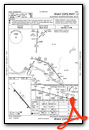
VFR Chart of KKLS
Sectional Charts at SkyVector.com
IFR Chart of KKLS
Enroute Charts at SkyVector.com
Location Information for KKLS
Coordinates: N46°7.08' / W122°53.90'Located 02 miles SE of Kelso, Washington on 110 acres of land. View all Airports in Washington.
Surveyed Elevation is 20 feet MSL.
Operations Data
|
|
Airport Communications
| AWOS-3PT: | 135.075 Tel. 360-577-1964 |
|---|---|
| CTAF: | 122.725 |
| UNICOM: | 122.725 |
| ASOS at SPB (20.9 S): | 135.875 503-543-6401 |
| ASOS at VUO (31.5 S): | 135.125 360-696-1280 |
| AWOS-3 at CLS (33.7 N): | 118.025 360-740-5164 |
- APCH/DEP CTL SVC PRVDD BY SEATTLE ARTCC (ZSE) ON FREQS 124.2/317.6 (SCAPPOOSE RCAG).
- COMMUNICATIONS PRVDD BY SEATTLE RADIO ON FREQ 122.4 (SOUTHWEST WASHINGTON RCO).
Nearby Navigation Aids
|
| ||||||||||||||||||||||||||||||||||||||||||


Runway 12/30
| Dimensions: | 4391 x 100 feet / 1338 x 30 meters | |
|---|---|---|
| Surface: | Asphalt in Good Condition | |
| Weight Limits: | S-38, D-46, ST-74 | |
| Edge Lighting: | Medium Intensity RY 12/30 MIRL NSTD SPACING. | |
| Runway 12 | Runway 30 | |
| Coordinates: | N46°7.36' / W122°54.23' | N46°6.80' / W122°53.57' |
| Elevation: | 20.0 | 15.9 |
| Traffic Pattern: | Right | Left |
| Runway Heading: | 140° True | 320° True |
| Markings: | Non-Precision Instrument in good condition. | Non-Precision Instrument in good condition. |
| Glide Slope Indicator | P4R (4.00° Glide Path Angle) | P4L (4.00° Glide Path Angle) |
| REIL: | Yes | Yes |
| Obstacles: | 45 ft Trees 1300 ft from runway, 110 ft left of center | +3' HILL FROM 40' TO 200'; 105L. |
Services Available
| Fuel: | 100LL (blue), Jet-A |
|---|---|
| Transient Storage: | Tiedowns PILOTS BRING OWN TIEDOWNS. |
| Airframe Repair: | MAJOR |
| Engine Repair: | MAJOR |
| Bottled Oxygen: | NONE |
| Bulk Oxygen: | NONE |
| Other Services: | AVIONICS,PILOT INSTRUCTION,AIRCRAFT RENTAL |
Ownership Information
| Ownership: | Publicly owned | |
|---|---|---|
| Owner: | CITY OF KELSO | |
| 203 S. PACIFIC AVE , PO BOX 819 | ||
| KELSO, WA 98626 | ||
| 360-577-3370 | ||
| Manager: | CRAIG STOMMEL | |
| PO BOX 818 | ARPT OFC ADS (NOT FOR MAILING): 2215 B PARROTT WAY, KELSO, WA 98626 | |
| KELSO, WA 98626 | ||
| 360-261-8268 | ||
Other Remarks
- NMRS FLOCKS OF BIRDS ON & INVOF ARPT.
- NO FLD COND NOTAMS AVBL M-F 1700-0800.
- FOR CD IF UNA TO CTC ON FSS FREQ, CTC SEATTLE ARTCC AT 253-351-3694.
- 0LL 24 HR SELF SVC CREDIT CARD FUEL FAC 100LL. AFT HRS JET-A SVC CALL-OUT AVBL.
- ACTVT REIL RWY 12 & 30; PAPI RWY 12 & 30; MIRL RWY 12/30 - CTAF.
Weather Minimums


Instrument Approach Procedure (IAP) Charts
Departure Procedure Obstacles (DPO) Charts

Nearby Airports with Instrument Procedures
| ID | Name | Heading / Distance | ||
|---|---|---|---|---|
 |
KSPB | Scappoose Airport | 175° | 20.9 |
|
KTDO | Ed Carlson Memorial Field/South Lewis County Airport | 010° | 21.9 |
|
KVUO | Pearson Field Airport | 161° | 31.5 |
|
KCLS | Chehalis-Centralia Airport | 354° | 33.7 |
|
KPDX | Portland International Airport | 158° | 34.2 |
|
KHIO | Portland-Hillsboro Airport | 183° | 34.6 |
|
KTTD | Portland-Troutdale Airport | 148° | 40.0 |
|
KAST | Astoria Regional Airport | 273° | 41.0 |
|
KOLM | Olympia Regional Airport | 359° | 51.1 |
|
KUAO | Aurora State Airport | 174° | 52.5 |
|
KMMV | Mc Minnville Municipal Airport | 190° | 56.3 |
|
KTMK | Tillamook Airport | 222° | 57.0 |
Airport Images
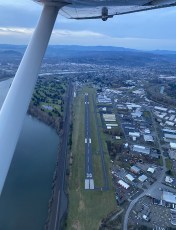
By: CascadeAir
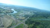
By: blendy


