Login
Register


UAO
Aurora State Airport
Official FAA Data Effective 2026-01-22 0901Z
Chart Supplement

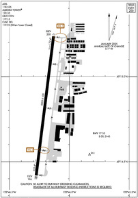
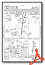
KUAO Airport Diagram
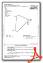
VFR Chart of KUAO
Sectional Charts at SkyVector.com
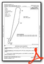
IFR Chart of KUAO
Enroute Charts at SkyVector.com
Location Information for KUAO
Coordinates: N45°14.83' / W122°46.20'Located 01 miles NW of Aurora, Oregon on 144 acres of land. View all Airports in Oregon.
Surveyed Elevation is 199 feet MSL.
Operations Data
|
|
Airport Communications
| ATIS: | 118.525 (503-678-3011) |
|---|---|
| ASOS: | 118.525 Tel. 503-678-3011 |
| AURORA TWR TOWER: | 120.35 |
| AURORA TWR GROUND: | 119.15 |
| PORTLAND APPROACH: | 118.1 ;HIGH 126.0 ;LOW 269.175 ;LOW 284.6 ;HIGH |
| PORTLAND DEPARTURE: | 118.1 ;HIGH 126.0 ;LOW 269.175 ;LOW 284.6 ;HIGH |
| CLEARANCE DELIVERY: | 119.15 119.95 ;WHEN TWR CLSD |
| HELNS STAR: | 124.35 299.2 |
| CTAF: | 120.350 |
| ASOS at MMV (15.7 W): | 135.675 503-434-9153 |
| ATIS at HIO (19.3 NW): | 127.65 |
| ASOS at HIO (19.7 NW): | 503-615-4314 |
Nearby Navigation Aids
|
| ||||||||||||||||||||||||||||||||||||||||||||||||


Runway 17/35
| Dimensions: | 5003 x 100 feet / 1525 x 30 meters RY 17/35 150 FT BLAST PAD AT SOUTH END. | |
|---|---|---|
| Surface: | Asphalt / Grooved in Excellent Condition | |
| Weight Limits: | S-30, D-45 | |
| Edge Lighting: | Medium Intensity | |
| Runway 17 | Runway 35 | |
| Coordinates: | N45°15.24' / W122°46.13' | N45°14.42' / W122°46.28' |
| Elevation: | 199.5 | 196.3 |
| Traffic Pattern: | Left | Left |
| Runway Heading: | 187° True | 7° True |
| Markings: | Precision Instrument in good condition. | Precision Instrument in good condition. |
| Glide Slope Indicator | V4R (3.50° Glide Path Angle) | V4L (3.25° Glide Path Angle) |
| Approach Lights: | ODALS Omnidirectional Approach Lighting System | |
| Obstacles: | 100 ft Trees 2939 ft from runway, 175 ft right of center | 90 ft Tree 1634 ft from runway, 520 ft left of center |
Services Available
| Fuel: | 100LL (blue), Jet-A |
|---|---|
| Transient Storage: | Tiedowns |
| Airframe Repair: | MAJOR |
| Engine Repair: | MAJOR |
| Bottled Oxygen: | NONE |
| Bulk Oxygen: | HIGH |
| Other Services: | AIR AMBULANCE SERVICES,AVIONICS,CHARTER SERVICE,PILOT INSTRUCTION,AIRCRAFT RENTAL,AIRCRAFT SALES |
Ownership Information
| Ownership: | Publicly owned | |
|---|---|---|
| Owner: | OREGON DEPT OF AVIATION | |
| 3040 25TH ST SE | ||
| SALEM, OR 97302-1125 | ||
| 503-378-4880 | ||
| Manager: | ANTHONY BEACH | ANTHONY.BEACH@ODAV.OREGON.GOV |
| 3040 25TH ST SE | ||
| SALEM, OR 97302-1125 | ||
| 503-378-4880 | ||
Other Remarks
- RY 35 CALM WIND RY. USE ONLY PAVED SFCS. FREQUENT STRAIGHT IN INSTRUMENT APCH TFC TO RY 17.
- OVERWEIGHT ACFT CTC OWNER PRIOR 503-378-4880
- RY 17 +30 FT PLINE 2100 FT FM THLD; MKD BY BALLS.
- PARALLEL TWY 35 FT WIDE AND HAS MEDIUM INTENSITY TWY LGTS.
- MIGRATORY BIRDS, COYOTES, AND DEER ON AND INVOF ARPT.
- NOISE ABATEMENT SENS AREA: 2 MI N OF RWY 17; 1 MI SE OF RWY 35; HLF MI SW OF RWY 35. AVOID LOW LEVEL OVER-FLIGHTS OF RESIDENTIAL AREAS SRNDG ARPT WHENEVER POSS.
- NOISE ABATEMENT PROC IN EFCT, CTC OPS FOR NOISE RULES 503-931-4298.
- ALL TAXILANES NON STD WINGTIP CLNC.
- ACTVT MIRL RY 17/35, VASI RYS 17 & 35 AND ODALS RY 17 - CTAF.
Weather Minimums

Standard Terminal Arrival (STAR) Charts
Instrument Approach Procedure (IAP) Charts

Departure Procedure (DP) Charts

Nearby Airports with Instrument Procedures
| ID | Name | Heading / Distance | ||
|---|---|---|---|---|
 |
KMMV | Mc Minnville Municipal Airport | 258° | 15.8 |
|
KHIO | Portland-Hillsboro Airport | 336° | 19.3 |
|
KPDX | Portland International Airport | 019° | 21.8 |
|
KSLE | Mcnary Field Airport | 206° | 22.5 |
|
KVUO | Pearson Field Airport | 012° | 22.9 |
|
KTTD | Portland-Troutdale Airport | 040° | 23.9 |
|
KSPB | Scappoose Airport | 353° | 31.7 |
|
S12 | Albany Municipal Airport | 198° | 38.6 |
|
KTMK | Tillamook Airport | 283° | 45.4 |
|
KCVO | Corvallis Municipal Airport | 206° | 50.2 |
|
KKLS | Southwest Washington Regional Airport | 354° | 52.5 |
|
KONP | Newport Municipal Airport | 234° | 67.9 |
Airport Images

By: henderson503

By: jimson


