Login
Register
MLF
Milford Municipal/Ben and Judy Briscoe Field Airport
Official FAA Data Effective 2025-11-27 0901Z
VFR Chart of KMLF
Sectional Charts at SkyVector.com
IFR Chart of KMLF
Enroute Charts at SkyVector.com
Location Information for KMLF
Coordinates: N38°25.60' / W113°0.80'Located 02 miles N of Milford, Utah on 556 acres of land. View all Airports in Utah.
Surveyed Elevation is 5042 feet MSL.
Operations Data
|
|
Airport Communications
| ASOS: | 135.025 Tel. 435-387-5201 |
|---|---|
| CTAF: | 122.800 |
| UNICOM: | 122.800 |
| AWOS-3PT at U52 (19.9 SE): | 119.925 435-438-5829 |
| ASOS at CDC (43.4 S): | 119.025 435-867-0278 |
| AWOS-3PT at FOM (44.4 NE): | 133.775 435-743-4182 |
- COMMUNICATIONS PRVDD BY CEDAR CITY RADIO ON FREQS 112.1T 122.1R (MILFORD RCO).
- APCH/DEP CTL SVC PRVDD BY SALT LAKE ARTCC (ZLC) ON 125.575/379.275 (CEDAR CITY RCAG).
Nearby Navigation Aids
|
| ||||||||||||||||||||||||||||||||||||
Runway 16/34
| Dimensions: | 5004 x 75 feet / 1525 x 23 meters | |
|---|---|---|
| Surface: | Asphalt in Good Condition | |
| Weight Limits: | S-26 | |
| Edge Lighting: | Medium Intensity | |
| Runway 16 | Runway 34 | |
| Coordinates: | N38°26.01' / W113°0.79' | N38°25.19' / W113°0.80' |
| Elevation: | 5024.8 | 5042.2 |
| Traffic Pattern: | Left | Left |
| Runway Heading: | 180° True | 0 |
| Markings: | Non-Precision Instrument in good condition. | Non-Precision Instrument in good condition. |
| Glide Slope Indicator | P2L (3.00° Glide Path Angle) | P2L (3.00° Glide Path Angle) |
| REIL: | Yes | Yes |
Services Available
| Fuel: | 100LL (blue), Jet-A |
|---|---|
| Transient Storage: | Tiedowns |
| Airframe Repair: | NONE |
| Engine Repair: | NONE |
| Bottled Oxygen: | NONE |
| Bulk Oxygen: | NONE |
Ownership Information
| Ownership: | Publicly owned | |
|---|---|---|
| Owner: | CITY OF MILFORD | |
| PO BOX 69, 26 SOUTH 100 WEST | ||
| MILFORD, UT 84751 | ||
| 435-387-2711 | ||
| Manager: | MAKAYLA BEALER | CITY/AMGR. |
| PO BOX 69, 26 SOUTH 100 WEST | ||
| MILFORD, UT 84751 | ||
| 435-463-9565 | ||
Other Remarks
- PILOTS ADZ TGL OVR CTAF.
- FOR CD IF UNA TO CTC ON FSS FREQ, CTC SALT LAKE ARTCC AT 801-320-2568.
- COLD TEMPERATURE AIRPORT. ALTITUDE CORRECTION REQUIRED AT OR BELOW -27C.
- ACTVT REIL RWY 16 & 34; MIRL RWY 16/34 - CTAF. PAPI RWY 16 & 34 ON CONSLY.
Weather Minimums
Instrument Approach Procedure (IAP) Charts
Nearby Airports with Instrument Procedures
| ID | Name | Heading / Distance | ||
|---|---|---|---|---|
 |
U52 | Beaver Municipal Airport | 126° | 19.8 |
 |
KCDC | Cedar City Regional Airport | 185° | 43.7 |
 |
KFOM | Fillmore Municipal Airport | 043° | 44.1 |
 |
U55 | Panguitch Municipal Airport | 139° | 45.6 |
 |
KRIF | Richfield Municipal Airport | 066° | 46.7 |
 |
KBCE | Bryce Canyon Airport | 136° | 59.6 |
 |
KDTA | Delta Municipal Airport | 022° | 62.1 |
 |
1L7 | Escalante Municipal Airport | 120° | 79.6 |
 |
41U | Manti-Ephraim Airport | 049° | 85.1 |
 |
KSGU | St George Regional Airport | 196° | 86.6 |
 |
KKNB | Kanab Municipal Airport | 164° | 87.9 |
 |
KAZC | Colorado City Municipal Airport | 180° | 87.9 |


Comments
Good Stop and Go
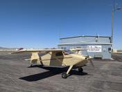
Nice runway. Bathrooms and self serve fuel at terminal. No other services. Close to town.