Login
Register


OLD
Dewitt Field/Old Town Municipal Airport
Official FAA Data Effective 2026-01-22 0901Z
Chart Supplement

VFR Chart of KOLD
Sectional Charts at SkyVector.com
IFR Chart of KOLD
Enroute Charts at SkyVector.com
Location Information for KOLD
Coordinates: N44°57.14' / W68°40.47'Located 02 miles NW of Old Town, Maine on 360 acres of land. View all Airports in Maine.
Surveyed Elevation is 126 feet MSL.
Operations Data
|
|
Airport Communications
| BANGOR APPROACH: | 118.925 239.3 |
|---|---|
| BANGOR DEPARTURE: | 118.925 239.3 |
| UNICOM: | 122.800 |
| CTAF: | 122.800 |
| ASOS at BGR (10.9 SW): | 127.75 207-561-2515 |
| ATIS at BGR (10.9 SW): | 127.75 |
| AWOS-3PT at BHB (33.0 SE): | 118.35 207-667-7364 |
Nearby Navigation Aids
|
| ||||||||||||||||||||||||||||||||||||||||||||||||||||||


Runway 17W/35W
| Dimensions: | 8400 x 100 feet / 2560 x 30 meters | |
|---|---|---|
| Surface: | Water | |
| Runway 17W | Runway 35W | |
| Elevation: | 102.0 | 102.0 |
| Traffic Pattern: | Left | Left |
Runway 12/30
| Dimensions: | 4001 x 75 feet / 1220 x 23 meters | |
|---|---|---|
| Surface: | Asphalt in Good Condition | |
| Weight Limits: | S-30 | |
| Edge Lighting: | Medium Intensity | |
| Runway 12 | Runway 30 | |
| Coordinates: | N44°57.22' / W68°40.97' | N44°57.14' / W68°40.04' |
| Elevation: | 124.7 | 119.1 |
| Traffic Pattern: | Left | Left |
| Runway Heading: | 97° True | 277° True |
| Displaced Threshold: | 689 Feet | |
| Markings: | Non-Precision Instrument in good condition. | Non-Precision Instrument in good condition. |
| Glide Slope Indicator | P4L (4.00° Glide Path Angle) | |
Runway 04/22
| Dimensions: | 2802 x 75 feet / 854 x 23 meters | |
|---|---|---|
| Surface: | Asphalt in Good Condition | |
| Weight Limits: | S-37, D-45 | |
| Edge Lighting: | Medium Intensity | |
| Runway 04 | Runway 22 | |
| Coordinates: | N44°56.87' / W68°40.54' | N44°57.29' / W68°40.30' |
| Elevation: | 125.9 | 122.2 |
| Traffic Pattern: | Left | Left |
| Runway Heading: | 22° True | 202° True |
| Markings: | Non-Precision Instrument in good condition. | Non-Precision Instrument in good condition. |
| Glide Slope Indicator | P4L (4.00° Glide Path Angle) | |
| REIL: | Yes | |
Services Available
| Fuel: | 100LL (blue), Jet-A |
|---|---|
| Transient Storage: | Tiedowns |
| Airframe Repair: | MAJOR |
| Engine Repair: | MAJOR |
| Bottled Oxygen: | NOT AVAILABLE |
| Bulk Oxygen: | NONE |
| Other Services: | BEACHING GEAR,PILOT INSTRUCTION,AIRCRAFT RENTAL,ANNUAL SURVEYING |
Ownership Information
| Ownership: | Publicly owned | |
|---|---|---|
| Owner: | CITY OF OLD TOWN | |
| 265 MAIN ST | ||
| OLD TOWN, ME 04468 | ||
| 207-827-3965 | ALTN CTC: BILL MAYO, CITY MGR 207-827-3965-EXT 201. | |
| Manager: | MILES FRANCES | |
| 100 AIRPORT RD, PO BOX 558 | ||
| OLD TOWN, ME 04468 | ||
| 207-827-7175 | ||
Other Remarks
- WATERFOWL, TURKEY & DEER ON & INVOF ARPT.
- FBO CLSD SUN.
- FOR CD CTC BANGOR APCH AT 207-561-2500 EXTN 1.
- 0LL 24 HR FUEL WITH CREDIT CARD.
- SELF SVC FUEL 24 HRS WITH CREDIT CARD.
- ACTVT REIL RWY 04; PAPI RWY 22 & 30; MIRL RWY 04/22 & 12/30 - CTAF.
Weather Minimums
Instrument Approach Procedure (IAP) Charts


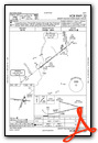
Nearby Airports with Instrument Procedures
| ID | Name | Heading / Distance | ||
|---|---|---|---|---|
 |
KBGR | Bangor International Airport | 217° | 10.9 |
|
1B0 | Dexter Regional Airport | 277° | 24.2 |
|
KLRG | Lincoln Regional Airport | 013° | 25.3 |
|
2B7 | Pittsfield Municipal Airport | 249° | 31.8 |
|
43B | Deblois Flight Strip Airport | 114° | 32.1 |
|
KBHB | Hancock County/Bar Harbor Airport | 155° | 33.0 |
|
KBST | Belfast Municipal Airport | 204° | 35.6 |
|
KMLT | Millinocket Municipal Airport | 359° | 41.7 |
|
3B1 | Greenville Municipal Airport | 309° | 48.2 |
|
KPNN | Princeton Municipal Airport | 072° | 49.5 |
|
KWVL | Waterville Regional Airport | 239° | 49.6 |
|
52B | Moosehead Aero Marine Seaplane Base | 308° | 50.4 |
Airport Images
Do you have a recent image of this airport? Upload it here!


