Login
Register


2B7
Pittsfield Municipal Airport
Official FAA Data Effective 2026-01-22 0901Z
Chart Supplement

VFR Chart of 2B7
Sectional Charts at SkyVector.com
IFR Chart of 2B7
Enroute Charts at SkyVector.com
Location Information for 2B7
Coordinates: N44°46.11' / W69°22.47'Located 01 miles SE of Pittsfield, Maine on 325 acres of land. View all Airports in Maine.
Surveyed Elevation is 197 feet MSL.
Operations Data
|
|
Airport Communications
| BANGOR APPROACH: | 118.925 239.3 |
|---|---|
| BANGOR DEPARTURE: | 118.925 239.3 |
| UNICOM: | 122.800 |
| CTAF: | 122.800 |
| AWOS-3PT at WVL (19.1 SW): | 118.375 207-877-0519 |
| AWOS-AV at OWK (21.2 W): | 123.075 |
| ATIS at BGR (23.4 E): | 127.75 |
Nearby Navigation Aids
|
| ||||||||||||||||||||||||||||||||||||||||||||||||||||||


Runway 18/36
| Dimensions: | 4003 x 100 feet / 1220 x 30 meters | |
|---|---|---|
| Surface: | Asphalt in Good Condition | |
| Weight Limits: | S-38, D-49 | |
| Edge Lighting: | Medium Intensity | |
| Runway 18 | Runway 36 | |
| Coordinates: | N44°46.43' / W69°22.57' | N44°45.79' / W69°22.37' |
| Elevation: | 197.1 | 176.3 |
| Traffic Pattern: | Left | Left |
| Runway Heading: | 167° True | 347° True |
| Markings: | Non-Precision Instrument in poor condition. | Non-Precision Instrument in poor condition. |
| Glide Slope Indicator | P4L (3.00° Glide Path Angle) | |
| REIL: | Yes | Yes |
| Obstacles: | 40 ft Pole 842 ft from runway, 257 ft left of center 6-10 FT BRUSH, 0-200 FT FM THR, 225-250 FT L OF CNTRLN. |
5 ft Brush 249 ft from runway, 181 ft right of center 20 FT TREES 0-50 FT FM THR, 210 FT L OF CNTRLN; 8 FT BRUSH 170-200 FT FM THR, 90 FT L OF CNTRLN. |
Services Available
| Fuel: | 100LL (blue), Jet A-1+ |
|---|---|
| Transient Storage: | Hangars,Tiedowns CALL 207-487-5213 FOR HNGR AVBL. |
| Airframe Repair: | MAJOR |
| Engine Repair: | MAJOR |
| Bottled Oxygen: | NONE |
| Bulk Oxygen: | NONE |
| Other Services: | CHARTER SERVICE,PILOT INSTRUCTION,AIRCRAFT RENTAL,AIRCRAFT SALES |
Ownership Information
| Ownership: | Publicly owned | |
|---|---|---|
| Owner: | TOWN OF PITTSFIELD | |
| 112 SOMERSET AVE | ||
| PITTSFIELD, ME 04967 | ||
| 207-487-3136 | ||
| Manager: | KATHRYN RUTH | TOWN MGR. |
| 112 SOMERSET AVE | ||
| PITTSFIELD, ME 04967 | ||
| 207-487-3136 | ||
Other Remarks
- DEER AND TURKEYS INVOF ARPT.
- FOR CD CTC BANGOR APCH AT 207-561-2500 EXTN 1.
- NRS AND CNTRLN FADED OR MISG.
- NRS AND CNTRLN FADED OR MISG.
- 0LL 100LL FUEL AFT HRS, CALL 207-232-2318.
- ACTVT REIL RWY 18 & 36; PAPI RWY 36; MIRL RWY 18/36 - CTAF.
Weather Minimums
Instrument Approach Procedure (IAP) Charts

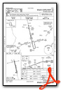
Nearby Airports with Instrument Procedures
| ID | Name | Heading / Distance | ||
|---|---|---|---|---|
 |
1B0 | Dexter Regional Airport | 022° | 15.3 |
|
KWVL | Waterville Regional Airport | 222° | 19.1 |
|
KOWK | Central Maine/Norridgewock Airport | 261° | 21.3 |
|
KBGR | Bangor International Airport | 084° | 23.5 |
|
KBST | Belfast Municipal Airport | 144° | 26.6 |
|
KOLD | Dewitt Field/Old Town Municipal Airport | 069° | 31.8 |
|
KAUG | Augusta State Airport | 214° | 32.4 |
|
B21 | Sugarloaf Regional Airport | 298° | 40.6 |
|
3B1 | Greenville Municipal Airport | 349° | 42.3 |
|
52B | Moosehead Aero Marine Seaplane Base | 347° | 43.5 |
|
KRKD | Knox County Regional Airport | 164° | 44.1 |
|
KBHB | Hancock County/Bar Harbor Airport | 113° | 47.4 |
Airport Images
Do you have a recent image of this airport? Upload it here!


