Login
Register
BHB
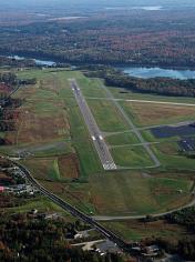
Hancock County/Bar Harbor Airport
Official FAA Data Effective 2025-11-27 0901Z
VFR Chart of KBHB
Sectional Charts at SkyVector.com
IFR Chart of KBHB
Enroute Charts at SkyVector.com
Location Information for KBHB
Coordinates: N44°26.98' / W68°21.69'Located 08 miles NW of Bar Harbor, Maine on 468 acres of land. View all Airports in Maine.
Surveyed Elevation is 83 feet MSL.
Operations Data
|
|
Airport Communications
| AWOS-3PT: | 118.35 Tel. 207-667-7364 |
|---|---|
| BANGOR APPROACH: | 133.6 284.65 |
| BANGOR DEPARTURE: | 133.6 284.65 |
| IC: | 133.6 |
| CLEARANCE DELIVERY: | 119.9 |
| CTAF: | 123.000 |
| UNICOM: | 123.000 |
| AWOS-AV at BST (28.0 W): | 122.975 207-930-7071 |
| ATIS at BGR (29.3 NW): | 127.75 |
| ASOS at BGR (29.3 NW): | 127.75 207-561-2515 |
Nearby Navigation Aids
|
| ||||||||||||||||||||||||||||||||||||||||||||||||
Runway 04/22
DUE TO HUMP AT MIDPT, OPPOSITE ENDS OF RWY NOT VSB AT GND LEVEL. | ||
| Dimensions: | 5200 x 100 feet / 1585 x 30 meters | |
|---|---|---|
| Surface: | Asphalt in Good Condition | |
| Weight Limits: | D-72, ST-100
PCR VALUE: 350/F/D/X/T
| |
| Edge Lighting: | High Intensity | |
| Runway 04 | Runway 22 | |
| Coordinates: | N44°26.63' / W68°22.04' | N44°27.41' / W68°21.54' |
| Elevation: | 69.0 | 69.1 |
| Traffic Pattern: | Left | Left |
| Runway Heading: | 25° True | 205° True |
| Declared Distances: | TORA:5200 TODA:5200 ASDA:5200 LDA:5200 | TORA:5200 TODA:5200 ASDA:5200 LDA:5200 |
| Markings: | Non-Precision Instrument in good condition. | Precision Instrument in good condition. |
| Glide Slope Indicator | V4L (3.00° Glide Path Angle) | V4L (3.00° Glide Path Angle) |
| Approach Lights: | MALSF 1,400 Foot Medium-intensity Approach Lighting System with sequenced flashers. | |
| REIL: | Yes | |
| Obstacles: | 125 ft Trees 1410 ft from runway, 500 ft left of center | |
Runway 17/35
RWY 17/35 NOT AVBL FOR PART 121/PART 380 OPS WITH SKED PAX CARRYING OPS MORE THAN 9 PAX SEATS AND NON-SKED PAX CARRYING OPS MORE THAN 30 PAX SEATS. NO PART 121/PART 380 OPS EXC FOR TAX ON RWY 17/35 BTN 04/22 AND TWY H. | ||
| Dimensions: | 3363 x 75 feet / 1025 x 23 meters | |
|---|---|---|
| Surface: | Asphalt in Good Condition | |
| Weight Limits: | S-13, D-20
PCR VALUE: 40/F/D/Y/U
| |
| Runway 17 | Runway 35 | |
| Coordinates: | N44°27.16' / W68°21.73' | N44°26.68' / W68°21.34' |
| Elevation: | 78.6 | 43.0 |
| Traffic Pattern: | Left | Left |
| Runway Heading: | 150° True | 330° True |
| Displaced Threshold: | 684 Feet | 111 Feet |
| Markings: | Basic in good condition. | Basic in good condition. |
| Obstacles: | 148 ft Tree 900 ft from runway, 60 ft right of center 10:1 TO DTHR. |
|
Services Available
| Fuel: | 100LL (blue), Jet-A |
|---|---|
| Transient Storage: | Hangars,Tiedowns |
| Airframe Repair: | MINOR |
| Engine Repair: | MINOR |
| Bottled Oxygen: | NONE |
| Bulk Oxygen: | NONE |
| Other Services: | PILOT INSTRUCTION,AIRCRAFT RENTAL |
Ownership Information
| Ownership: | Publicly owned | |
|---|---|---|
| Owner: | HANCOCK COUNTY | |
| 50 STATE ST, STE 7 | ||
| ELLSWORTH, ME 04605 | ||
| 207-667-9542 | ||
| Manager: | LEROY MUISE | |
| 115 CARUSO DR | ||
| TRENTON, ME 04605 | ||
| 207-667-7329 | ||
Other Remarks
- FICON NOT MNT MON-FRI 2100-0730, WKENDS & HOLS.
- IF CD FREQ UNAVBL CTC BANGOR APCH AT 207-561-2500 EXTN 1.
- GRASS AREAS UNAVBL FOR ACFT OPS.
- 48 HR PPR FOR UNSKED ACR OPS AT LEAST 31 PAX SEATS. CTC AMGR.
- BIRDS ON & INVOF ARPT.
- DURG VFR CONDS WHEN WIND SPEED LESS THAN 5 KTS AS RPRTD BY AWOS OR UNICOM, ALL ACFT USING RWY 04/22 ARE REQD TO TKOF & LAND ON RWY 22 FOR NOISE ABATEMENT PROCS.
- TWY BRAVO CLSD TO ALL ACFT GTR THAN 10000 LBS.
- PPR FOR OVERWEIGHT LDGS. PPR FOR UNSKED ACR OPS RQRG 14 CFR 139 ARFF. CTC AMGR.
- TWYS F & G CLSD DEC 1- MAR 31 ANNUALLY.
- SEAPLANE RAMP UNAVBL FOR ACFT OPS EXC PPR 207-667-7329.
- ACTVT MALSF RWY 22; REIL RWY 04; VASI RWY 04 & 22; HIRL RWY 04/22 - 122.7.
Weather Minimums
Instrument Approach Procedure (IAP) Charts
Nearby Airports with Instrument Procedures
| ID | Name | Heading / Distance | ||
|---|---|---|---|---|
 |
43B | Deblois Flight Strip Airport | 043° | 23.0 |
 |
KBST | Belfast Municipal Airport | 265° | 28.1 |
 |
KBGR | Bangor International Airport | 317° | 29.3 |
 |
KOLD | Dewitt Field/Old Town Municipal Airport | 336° | 33.0 |
 |
KRKD | Knox County Regional Airport | 233° | 39.5 |
 |
KMVM | Machias Valley Airport | 067° | 40.8 |
 |
2B7 | Pittsfield Municipal Airport | 294° | 47.4 |
 |
1B0 | Dexter Regional Airport | 311° | 50.1 |
 |
KLRG | Lincoln Regional Airport | 352° | 55.2 |
 |
KPNN | Princeton Municipal Airport | 036° | 56.5 |
 |
KWVL | Waterville Regional Airport | 275° | 56.7 |
 |
KAUG | Augusta State Airport | 263° | 62.3 |


