Login
Register


SFY
Tri-Township Airport
Official FAA Data Effective 2026-01-22 0901Z
Chart Supplement

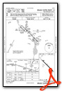
VFR Chart of KSFY
Sectional Charts at SkyVector.com
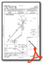
IFR Chart of KSFY
Enroute Charts at SkyVector.com
Location Information for KSFY
Coordinates: N42°2.75' / W90°6.48'Located 03 miles SE of Savanna, Illinois on 140 acres of land. View all Airports in Illinois.
Surveyed Elevation is 616 feet MSL.
Operations Data
|
|
Airport Communications
| AWOS-3PT: | 118.650 Tel. 815-273-4429 |
|---|---|
| QUAD CITY APPROACH: | 125.95 257.8 |
| QUAD CITY DEPARTURE: | 125.95 257.8 |
| UNICOM: | 122.700 |
| CTAF: | 122.700 |
| AWOS-3PT at CWI (16.3 SW): | 125.525 563-243-8934 |
| AWOS-3 at FEP (26.3 NE): | 120.525 815-233-4472 |
| AWOS-3PT at SQI (26.5 SE): | 119.175 815-626-2704 |
- APCH/DEP SVC PRVDD BY CHICAGO ARTCC ON FREQS 118.75/377.05 (MOLINE RCAG) WHEN QUAD CITY APCH CLSD.
Nearby Navigation Aids
|
| ||||||||||||||||||||||||||||||||||||


Runway 13/31
| Dimensions: | 4001 x 75 feet / 1220 x 23 meters | |
|---|---|---|
| Surface: | Asphalt in Good Condition | |
| Weight Limits: | S-14, D-23 | |
| Edge Lighting: | Medium Intensity | |
| Runway 13 | Runway 31 | |
| Coordinates: | N42°2.99' / W90°6.79' | N42°2.52' / W90°6.17' |
| Elevation: | 612.1 | 612.9 |
| Traffic Pattern: | Left | Left |
| Runway Heading: | 135° True | 315° True |
| Markings: | Non-Precision Instrument in fair condition. | Non-Precision Instrument in fair condition. |
| Glide Slope Indicator | P2L (3.40° Glide Path Angle) PAPI UNUSBL BYD 8 DEG RIGHT OF CNTRLN. | P2L (3.00° Glide Path Angle) PAPI UNUSBL BYD 7 DEG LEFT AND 9 DEG RIGHT OF CNTRLN. |
| Obstacles: | 15 ft Road 310 ft from runway, 255 ft right of center | |
Services Available
| Fuel: | 100LL (blue), Automotive Gasoline |
|---|---|
| Transient Storage: | Tiedowns |
| Airframe Repair: | NOT AVAILABLE |
| Engine Repair: | NOT AVAILABLE |
| Bottled Oxygen: | NOT AVAILABLE |
| Bulk Oxygen: | NOT AVAILABLE |
Ownership Information
| Ownership: | Publicly owned | |
|---|---|---|
| Owner: | TRI-TOWNSHIP MUNI ARPT AUTH | |
| 8049 IL RT 84 SOUTH | ||
| SAVANNA, IL 61074 | ||
| 815-273-3555 | ||
| Manager: | DALE BROWN | |
| 8049 IL RT 84 SOUTH | ||
| SAVANNA, IL 61074 | ||
| 815-273-3555 | ||
Other Remarks
- IRRIGATION SPRINKLER SYSTEM OPS SEASONALLY UNDER RWY 31.
- FOR CD CTC CHICAGO ARTCC AT 630-906-8921.
- 0LL FUEL AVBL 24 HRS WITH CREDIT CARD.
- ACTVT PAPI RWY 13 & 31; TWY LGTS - CTAF. MIRL RWY 13/31 PRESET ON LOW INTST, TO INCR INTST & ACTVT - CTAF.
Weather Minimums


Instrument Approach Procedure (IAP) Charts
Nearby Airports with Instrument Procedures
| ID | Name | Heading / Distance | ||
|---|---|---|---|---|
 |
KCWI | Clinton Municipal Airport | 217° | 16.3 |
|
KFEP | Albertus Airport | 062° | 26.4 |
|
KSQI | Whiteside County/Jos H Bittorf Field Airport | 133° | 26.5 |
|
KOQW | Maquoketa Municipal Airport | 270° | 28.2 |
|
C73 | Dixon Municipal-Charles R Walgreen Field Airport | 113° | 32.2 |
|
KDVN | Davenport Municipal Airport | 219° | 33.9 |
|
KDBQ | Dubuque Regional Airport | 308° | 34.3 |
|
KMLI | Quad Cities International Airport | 206° | 40.1 |
|
KEFT | Monroe Municipal Airport | 033° | 41.2 |
|
KPVB | Platteville Municipal Airport | 338° | 41.4 |
|
KRFD | Chicago/Rockford International Airport | 078° | 46.0 |
|
KRPJ | Rochelle Municipal/Koritz Field Airport | 100° | 46.9 |
Airport Images

By: ronnatphi


