Login
Register


EFT
Monroe Municipal Airport
Official FAA Data Effective 2026-02-19 0901Z
Chart Supplement

VFR Chart of KEFT
Sectional Charts at SkyVector.com
IFR Chart of KEFT
Enroute Charts at SkyVector.com
Location Information for KEFT
Coordinates: N42°36.89' / W89°35.42'Located 03 miles NE of Monroe, Wisconsin on 257 acres of land. View all Airports in Wisconsin.
Surveyed Elevation is 1085 feet MSL.
Operations Data
|
|
Airport Communications
| AWOS-3: | 118.375 Tel. 608-328-8359 |
|---|---|
| ROCKFORD APPROACH: | 126.0 327.0 |
| ROCKFORD DEPARTURE: | 126.0 327.0 |
| UNICOM: | 123.050 |
| CTAF: | 123.050 |
| AWOS-3 at FEP (22.1 S): | 120.525 815-233-4472 |
| AWOS-3 at JVL (24.2 E): | 608-758-1723 |
| ATIS at JVL (24.3 E): | 128.25 |
Nearby Navigation Aids
|
| ||||||||||||||||||||||||||||||||||||||||||||||||


Runway 12/30
| Dimensions: | 5000 x 75 feet / 1524 x 23 meters | |
|---|---|---|
| Surface: | Asphalt in Excellent Condition | |
| Weight Limits: | S-12 | |
| Edge Lighting: | Medium Intensity | |
| Runway 12 | Runway 30 | |
| Coordinates: | N42°37.13' / W89°35.81' | N42°36.70' / W89°34.86' |
| Elevation: | 1085.5 | 1061.5 |
| Traffic Pattern: | Left | Left |
| Runway Heading: | 122° True | 302° True |
| Markings: | Non-Precision Instrument in good condition. | Non-Precision Instrument in good condition. |
| Glide Slope Indicator | P2L (3.15° Glide Path Angle) | P2L (3.00° Glide Path Angle) PAPI UNUSBL BYD 6 DEGS RIGHT OF CNTRLN. |
| REIL: | Yes | Yes |
Runway 02/20
| Dimensions: | 3000 x 75 feet / 914 x 23 meters | |
|---|---|---|
| Surface: | Asphalt in Fair Condition | |
| Edge Lighting: | Medium Intensity | |
| Runway 02 | Runway 20 | |
| Coordinates: | N42°36.63' / W89°35.67' | N42°37.10' / W89°35.48' |
| Elevation: | 1056.0 | 1084.8 |
| Traffic Pattern: | Left | Left |
| Runway Heading: | 16° True | 196° True |
| Markings: | Basic in fair condition. | Basic in fair condition. |
| Glide Slope Indicator | P2L (3.00° Glide Path Angle) | |
| REIL: | Yes | Yes |
Helipad H1
| Dimensions: | 50 x 50 feet / 15 x 15 meters | |
|---|---|---|
| Surface: | Asphalt | |
| Coordinates: | N42°37.15' / W89°35.53' | N0°0.00' / E0°0.00' |
| Elevation: | 1084.0 | |
Services Available
| Fuel: | 100LL (blue), Jet A+ |
|---|---|
| Transient Storage: | Hangars,Tiedowns |
| Airframe Repair: | MAJOR |
| Engine Repair: | MAJOR |
| Bottled Oxygen: | HIGH/LOW |
| Bulk Oxygen: | NONE |
| Other Services: | PILOT INSTRUCTION,AIRCRAFT RENTAL |
Ownership Information
| Ownership: | Publicly owned | |
|---|---|---|
| Owner: | CITY OF MONROE | |
| 1110 18TH AVENUE | ||
| MONROE, WI 53566 | ||
| 608-329-4101 | ||
| Manager: | ROB DRIVER | |
| W4711 HWY 59 | ||
| MONROE, WI 53566 | ||
| (608) 329-7777 | ||
Other Remarks
- FOR CD CTC CHICAGO ARTCC AT 630-906-8921.
- 0LL 24 HR FUEL AVBL WITH CREDIT CARD.
- MIRL RWY 12/30 PRESET LOW SS-SR; TO INCR INTST & ACTVT REIL RWY 02, 12, 20 & 30; PAPI RWY 02, 12 & 30; MIRL RWY 02/20 & 12/30 - CTAF.
Weather Minimums


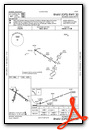
Instrument Approach Procedure (IAP) Charts


Nearby Airports with Instrument Procedures
| ID | Name | Heading / Distance | ||
|---|---|---|---|---|
 |
KFEP | Albertus Airport | 179° | 22.1 |
|
KJVL | Southern Wisconsin Regional Airport | 089° | 24.3 |
|
44C | Beloit Airport | 104° | 28.5 |
|
C29 | Middleton Municipal/Morey Field Airport | 004° | 30.1 |
|
KMRJ | Iowa County Airport | 299° | 32.9 |
|
KRFD | Chicago/Rockford International Airport | 138° | 33.4 |
|
KMSN | Dane County Regional/Truax Field Airport | 019° | 33.4 |
|
87Y | Blackhawk Airfield Airport | 031° | 34.4 |
|
C77 | Poplar Grove Airport | 117° | 37.8 |
|
KPVB | Platteville Municipal Airport | 277° | 38.1 |
|
61C | Fort Atkinson Municipal Airport | 058° | 40.0 |
|
KSFY | Tri-Township Airport | 214° | 41.2 |
Airport Images
Do you have a recent image of this airport? Upload it here!


