Login
Register
TYS
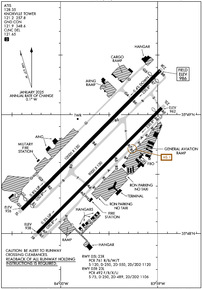
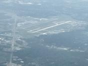
Mc Ghee Tyson Airport
Official FAA Data Effective 2025-12-25 0901Z
VFR Chart of KTYS
Sectional Charts at SkyVector.com
IFR Chart of KTYS
Enroute Charts at SkyVector.com
Location Information for KTYS
Coordinates: N35°48.67' / W83°59.64'Located 10 miles S of Knoxville, Tennessee on 2250 acres of land. View all Airports in Tennessee.
Surveyed Elevation is 986 feet MSL.
Operations Data
|
|
Airport Communications
| ATIS: | 128.35 |
|---|---|
| ASOS: | Tel. 423-219-5043 |
| KNOXVILLE TOWER: | 121.2 257.8 |
| KNOXVILLE GROUND: | 121.9 348.6 |
| KNOXVILLE APPROACH: | 118.0 ;051-229 123.9 ;230-050 125.525 353.6 ;230-050 360.8 ;051-229 |
| KNOXVILLE DEPARTURE: | 118.0 ;051-229 123.9 ;230-050 125.525 353.6 ;230-050 360.8 ;051-229 |
| IC: | 123.9 ;230-050 360.8 ;051-229 |
| CLEARANCE DELIVERY: | 121.65 |
| EMERG: | 121.5 243.0 |
| ARNG OPS: | 149.8 373.9 49.95 |
| ANG OPS: | 143.8 303.25 ;SODA CAN CON |
| UNICOM: | 122.950 |
| CLASS C: | 118.0 ;051-229 123.9 ;230-050 353.6 ;230-050 360.8 ;051-229 |
| AWOS-3 at DKX (11.0 NE): | 125.375 865-579-6151 |
| AWOS-3 at GKT (22.6 E): | 126.875 865-429-5401 |
| AWOS-3 at MNV (24.8 SW): | 118.475 423-442-6170 |
Nearby Navigation Aids
|
| ||||||||||||||||||||||||||||||||||||||||||||||||||||||||||||
Runway 05L/23R
RWY DIST RMNG SIGNS ARE OUT OF SVC. | ||
| Dimensions: | 10000 x 150 feet / 3048 x 46 meters | |
|---|---|---|
| Surface: | Concrete / Grooved in Good Condition | |
| Weight Limits: | S-120, D-250, ST-550, DT-1120
PCR VALUE: 761/R/B/W/T
| |
| Edge Lighting: | High Intensity | |
| Runway 05L | Runway 23R | |
| Coordinates: | N35°48.20' / W84°0.40' | N35°49.37' / W83°58.97' |
| Elevation: | 925.9 | 986.4 |
| Traffic Pattern: | Left | Right |
| Runway Heading: | 45° True | 225° True |
| Displaced Threshold: | 490 Feet | 505 Feet |
| Declared Distances: | TORA:10000 TODA:10000 ASDA:10000 LDA:9508 | TORA:10000 TODA:10000 ASDA:10000 LDA:9495 |
| Markings: | Precision Instrument in good condition. | Precision Instrument in good condition. |
| Glide Slope Indicator | P4L (3.00° Glide Path Angle) | P4L (3.00° Glide Path Angle) |
| RVR Equipment | Touchdown Midfield Rollout | Touchdown Midfield Rollout |
| Approach Lights: | MALSR 1,400 Foot Medium-intensity Approach Lighting System with runway alignment indicator lights. | ALSF2 Standard 2,400 Foot High-intensity Approach Lighting System with sequenced flashers, CATEGORY II or III Configuration. |
| Centerline Lights: | Yes | Yes |
Runway 05R/23L
| Dimensions: | 9000 x 150 feet / 2743 x 46 meters | |
|---|---|---|
| Surface: | Asphalt / Grooved in Poor Condition | |
| Weight Limits: | S-75, D-250, ST-489, DT-1106
PCR VALUE: 492/F/B/X/U
| |
| Edge Lighting: | High Intensity | |
| Runway 05R | Runway 23L | |
| Coordinates: | N35°48.00' / W84°0.24' | N35°49.06' / W83°58.96' |
| Elevation: | 938.3 | 962.3 |
| Traffic Pattern: | Right | Left |
| Runway Heading: | 45° True | 225° True |
| Displaced Threshold: | 397 Feet | |
| Declared Distances: | TORA:9000 TODA:9000 ASDA:8600 LDA:8600 | TORA:9000 TODA:9000 ASDA:9000 LDA:8600 |
| Markings: | Precision Instrument in good condition. | Precision Instrument in good condition. |
| Glide Slope Indicator | P4L (3.00° Glide Path Angle) | P4L (3.00° Glide Path Angle) |
| RVR Equipment | Rollout | Touchdown |
| REIL: | Yes | Yes |
| Centerline Lights: | Yes | Yes |
Services Available
| Fuel: | 100LL (blue), Jet-A, A++ |
|---|---|
| Transient Storage: | Hangars,Tiedowns |
| Airframe Repair: | MAJOR |
| Engine Repair: | MAJOR |
| Bottled Oxygen: | NOT AVAILABLE |
| Bulk Oxygen: | HIGH |
| Other Services: | AIR FREIGHT SERVICES,AVIONICS,CARGO HANDLING SERVICES,CHARTER SERVICE,PILOT INSTRUCTION,AIRCRAFT RENTAL,AIRCRAFT SALES,ANNUAL SURVEYING |
Ownership Information
| Ownership: | Publicly owned | |
|---|---|---|
| Owner: | METRO KNOXVILLE ARPT AUTH | |
| MC GHEE TYSON AIRPORT, 2055 ALCOA HWY | ||
| ALCOA, TN 37701 | ||
| 865-342-3000 | ||
| Manager: | PATRICK WILSON | |
| P.O. BOX 15600 | ||
| KNOXVILLE, TN 37901 | ||
| 865-342-3088 | ||
Other Remarks
- WIDE BODY USE CTN TURNING ONTO TWY A FM RAMP 4, 5 & 6.
- CTN: PTN OF TWY A NEAR RWY 05R APCH END NOT VSB FM TWR.
- ANG OPS CTC SODA CTL 303.025.
- ANG: COMD POST H24 - D266-4371/ C865-336-4371. AMGR DOES NOT ISSUE OR STORE COMSEC FOR TSNT. TMPRY STOR OF CLASSIFIED MATERIALS UP TO TOP SECRET AT COMD POST.
- ANG: PPR 24 HR PN RQR, LTD TO OFFL BUS ONLY, CTC AIRFIELD MGMT DSN 266-4404/4419, C865-336-4404/4419. OPR 0700-1630 MON-FRI (CLSD EV OTH MON), FAC CLSD SAT, SUN AND HOL.
- CTN: HOLD SHORT LINE FOR RWY 23L SLIGHTLY N OF TWY A-8.
- ANG: ARNG RAMP NOT SUITABLE FOR AMC ACFT EXC C-21.
- CSTMS/AG/IMG: MIL CUSTOMS 72 HR PPR.
- RWY 5L/23R & 5R/23L WT BRG CPTY FOR 2S LNDG GEAR IS 175.
- ACFT DESIGN GROUP V OR LRGR USING TRML RAMP RQR PPR 865-342-3177.
- GA RAMP NOT AVBL FOR ACR OPS.
- ARNG: BASEOPS OPR 0700-1630 MON-FRI (CLSD EV OTH MON), FAC CLSD SAT, SUN AND HOL. C865-985-4639/4644, DSN 683-4180.
- BIRDS ON & INVOF OF ARPT; INCRD OCT-APR.
- CIVIL PPR TO USE TWYS G1, G2, G3 & G SOUTH OF TWY G4 - ANG 865-336-4371.
- RWY 23L & 23R DEP MNTN RWY HDG UNTIL PASSING RESIDENTIAL AREA S OF EXTDD CNTRLN UNLESS INSTRD BY ATC.
- TDZL LTS REMOVED FM SVC WITH RWY REHAB PROJECT.
- 0LL MIL CONTR FUEL AVBL.
Weather Minimums
Instrument Approach Procedure (IAP) Charts
- HI-ILS OR LOC RWY 05L

- HI-ILS OR LOC RWY 23L

- HI-ILS OR LOC RWY 23R

- ILS OR LOC RWY 05L

- ILS OR LOC RWY 23L

- ILS OR LOC RWY 23R

- ILS RWY 23R (SA CAT I)

- ILS RWY 23R (CAT II)

- RNAV (GPS) RWY 05L

- RNAV (GPS) RWY 05R

- RNAV (GPS) RWY 23L

- RNAV (GPS) RWY 23R

- VOR RWY 23L

- VOR RWY 23R

- HI-VOR OR TACAN RWY 05L

- HI-VOR OR TACAN RWY 23R

Departure Procedure (DP) Charts
Nearby Airports with Instrument Procedures
| ID | Name | Heading / Distance | ||
|---|---|---|---|---|
 |
KDKX | Knoxville Downtown Island Airport | 032° | 10.9 |
 |
KGKT | Gatlinburg-Pigeon Forge Airport | 082° | 22.9 |
 |
KMNV | Monroe County Airport | 229° | 24.7 |
 |
KJAU | Colonel Tommy C Stiner Airfield Airport | 345° | 32.4 |
 |
KRKW | Rockwood Municipal Airport | 281° | 34.6 |
 |
KMMI | Mcminn County Airport | 228° | 37.2 |
 |
KMOR | Moore-Murrell Airport | 053° | 37.3 |
 |
KRHP | Western Carolina Regional Airport | 170° | 37.4 |
 |
3A2 | New Tazewell Municipal Airport | 030° | 41.6 |
 |
1A5 | Macon County Airport | 141° | 45.1 |
 |
KSCX | Scott Municipal Airport | 323° | 48.2 |
 |
24A | Jackson County Airport | 127° | 48.5 |


