Login
Register


SCX
Scott Municipal Airport
Official FAA Data Effective 2026-01-22 0901Z
Chart Supplement

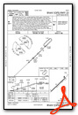
VFR Chart of KSCX
Sectional Charts at SkyVector.com
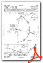
IFR Chart of KSCX
Enroute Charts at SkyVector.com
Location Information for KSCX
Coordinates: N36°27.34' / W84°35.15'Located 04 miles SW of Oneida, Tennessee on 144 acres of land. View all Airports in Tennessee.
Surveyed Elevation is 1544 feet MSL.
Operations Data
|
|
Airport Communications
| AWOS-3: | 135.025 Tel. 423-569-6651 |
|---|---|
| CTAF: | 122.800 |
| UNICOM: | 122.800 |
| AWOS-3 at JAU (21.7 E): | 124.975 423-566-6474 |
| AWOS-3PT at EKQ (27.3 NW): | 118.825 606-348-0862 |
| AWOS-3 at BYL (27.5 NE): | 119.575 606-549-1585 |
- APCH/DEP SVC PRVDD BY INDIANAPOLIS ARTCC ON FREQS 124.625/371.925 (LONDON 2 RCAG).
Nearby Navigation Aids
|
| ||||||||||||||||||||||||||||||||||||||||||||||||||||||


Runway 05/23
| Dimensions: | 5505 x 75 feet / 1678 x 23 meters | |
|---|---|---|
| Surface: | Asphalt in Fair Condition | |
| Weight Limits: | 7 /F/C/X/T, S-20 | |
| Edge Lighting: | Medium Intensity | |
| Runway 05 | Runway 23 | |
| Coordinates: | N36°27.03' / W84°35.55' | N36°27.65' / W84°34.74' |
| Elevation: | 1544.8 | 1521.9 |
| Traffic Pattern: | Left | Left |
| Runway Heading: | 46° True | 226° True |
| Markings: | Non-Precision Instrument in fair condition. | Non-Precision Instrument in fair condition. |
| Glide Slope Indicator | P4L (3.50° Glide Path Angle) | P4L (3.00° Glide Path Angle) |
| Approach Lights: | ODALS Omnidirectional Approach Lighting System | |
| REIL: | Yes | Yes |
| Obstacles: | 88 ft Trees 2063 ft from runway, 486 ft right of center | 125 ft Trees 3240 ft from runway, 703 ft left of center |
Services Available
| Fuel: | 100LL (blue), Jet A+ |
|---|---|
| Transient Storage: | Hangars,Tiedowns |
| Airframe Repair: | MAJOR |
| Engine Repair: | MAJOR |
| Bottled Oxygen: | LOW |
| Bulk Oxygen: | HIGH |
Ownership Information
| Ownership: | Publicly owned | |
|---|---|---|
| Owner: | SCOTT COUNTY | |
| 210 COURT STREET | ||
| HUNTSVILLE, TN 37756 | ||
| 423-663-2000 | ||
| Manager: | HANK DUVALL | |
| 2263 AIRPORT RD | ||
| ONEIDA, TN 37841 | ||
| 423-569-8270 | ||
Other Remarks
- WILDLIFE ON & INVOF ARPT.
- FOR CD CTC INDIANAPOLIS ARTCC AT 317-247-2411.
- AFT HR - 423-223-4331.
- 0LL FUEL 24 HR CREDIT CARD SVC AVBL.
- ACTVT ODALS RWY 23; REIL RWY 5 & 23; MIRL RWY 05/23 - CTAF. MIRL RWY 05/23 PRESET LOW INTST; INCR INTST - CTAF. PAPI RWY 05 & 23 OPR CONSLY.
Weather Minimums

Instrument Approach Procedure (IAP) Charts

Nearby Airports with Instrument Procedures
| ID | Name | Heading / Distance | ||
|---|---|---|---|---|
 |
18I | Mc Creary County Airport | 033° | 17.2 |
|
2A1 | Jamestown Municipal Airport | 250° | 18.6 |
|
KJAU | Colonel Tommy C Stiner Airfield Airport | 109° | 21.7 |
|
KEKQ | Wayne County Airport | 331° | 27.3 |
|
KBYL | Williamsburg-Whitley County Airport | 042° | 27.6 |
|
KRKW | Rockwood Municipal Airport | 189° | 32.4 |
|
8A3 | Livingston Municipal Airport | 266° | 35.2 |
|
KSME | Lake Cumberland Regional Airport | 357° | 35.9 |
|
KCSV | Crossville Memorial-Whitson Field Airport | 218° | 38.7 |
|
K24 | Russell County Airport | 323° | 41.5 |
|
1A6 | Middlesboro/Bell County Airport | 077° | 42.1 |
|
KLOZ | London/Corbin/Magee Airport | 032° | 45.1 |
Airport Images
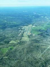
By: tshiverd


