Login
Register


UKI
Ukiah Municipal Airport
Official FAA Data Effective 2026-01-22 0901Z
Chart Supplement

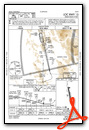
VFR Chart of KUKI
Sectional Charts at SkyVector.com
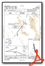
IFR Chart of KUKI
Enroute Charts at SkyVector.com
Location Information for KUKI
Coordinates: N39°7.56' / W123°12.05'Located 01 miles S of Ukiah, California on 160 acres of land. View all Airports in California.
Surveyed Elevation is 616 feet MSL.
Operations Data
|
|
Airport Communications
| ASOS: | 119.275 Tel. 707-462-7343 |
|---|---|
| CTAF: | 123.000 |
| UNICOM: | 123.000 |
| AWOS-3 at 1O2 (16.5 SE): | 118.35 707-262-0380 |
| AWOS-3 at LLR (26.9 W): | 121.125 707-937-6059 |
| AWOS-A at CN01 (33.3 NW): | 707-961-4603 |
- APCH/DEP CTL SVC PRVDD BY OAKLAND ARTCC (ZOA) ON FREQS 127.8/353.5 (UKIAH RCAG).
Nearby Navigation Aids
|
| ||||||||||||||||||||||||||||||||||||


Runway 15/33
| Dimensions: | 4423 x 150 feet / 1348 x 46 meters | |
|---|---|---|
| Surface: | Asphalt in Excellent Condition | |
| Weight Limits: | S-28 | |
| Edge Lighting: | Medium Intensity | |
| Runway 15 | Runway 33 | |
| Coordinates: | N39°7.91' / W123°12.15' | N39°7.20' / W123°11.96' |
| Elevation: | 616.8 | 604.7 |
| Traffic Pattern: | Left | Right |
| Runway Heading: | 168° True | 348° True |
| Markings: | Non-Precision Instrument in good condition. | Basic in good condition. |
| Glide Slope Indicator | P4L (3.00° Glide Path Angle) | |
| REIL: | Yes | Yes |
| Obstacles: | 27 ft Trees 950 ft from runway, 190 ft right of center | 27 ft Trees 700 ft from runway, 135 ft left of center |
Services Available
| Fuel: | 100LL (blue), Jet-A |
|---|---|
| Transient Storage: | Tiedowns |
| Airframe Repair: | MAJOR |
| Engine Repair: | MAJOR |
| Bottled Oxygen: | NONE |
| Bulk Oxygen: | HIGH |
| Other Services: | AIR AMBULANCE SERVICES,CHARTER SERVICE,PILOT INSTRUCTION,AIRCRAFT RENTAL,AIRCRAFT SALES |
Ownership Information
| Ownership: | Publicly owned | |
|---|---|---|
| Owner: | CITY OF UKIAH | |
| 300 SEMINARY AV | ||
| UKIAH, CA 95482 | ||
| 707-467-2855 | ||
| Manager: | GREG OWEN | |
| 1403 S. STATE STREET | ||
| UKIAH, CA 95482 | ||
| 707-467-2855 | ||
Other Remarks
- <NO JET ACFT DEPARTURES BETWEEN 2200-0700 LCL.
- <CALM WIND RWY IS 15 FOR NOISE ABATEMENT REASONS.
- NOISE ABATEMENT PROCEDURES: AMGR REQUESTS NO VFR STRAIGHT-IN APCHS TO RY 15/33, RIGHT TURN AFTER DEP RY 33 TO AVOID OVERFLIGHT OF TOWN.
- FOR CD IF UNA TO CTC ON FSS FREQ, CTC OAKLAND ARTCC AT 510-745-3380.
- 0LL SELF-SERVICE FUEL AVBL.
- ACTVT PAPI RWY 15; REIL RWY 15 & 33; MIRL RWY 15/33 - CTAF.
- DUSK-DAWN
Weather Minimums


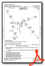
Instrument Approach Procedure (IAP) Charts


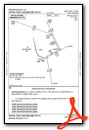
Departure Procedure (DP) Charts
Nearby Airports with Instrument Procedures
| ID | Name | Heading / Distance | ||
|---|---|---|---|---|
 |
1O2 | Lampson Field Airport | 119° | 16.2 |
|
O28 | Ells Field/Willits Municipal Airport | 337° | 21.1 |
|
O60 | Cloverdale Municipal Airport | 154° | 23.1 |
|
KLLR | Little River Airport | 287° | 27.1 |
|
KHES | Healdsburg Municipal Airport | 153° | 31.7 |
|
KSTS | Charles M Schulz/Sonoma County Airport | 153° | 41.2 |
|
KWLW | Willows/Glenn County Airport | 062° | 51.4 |
|
O08 | Colusa County Airport | 086° | 56.4 |
|
O69 | Petaluma Municipal Airport | 151° | 59.1 |
|
O37 | Haigh Field Airport | 053° | 60.6 |
|
KDVO | Gnoss Field Airport | 152° | 66.2 |
|
O41 | Watts-Woodland Airport | 113° | 67.9 |
Airport Images

By: Gtowen77@gmail.com

By: Gtowen77@gmail.com


