Login
Register


VLD
Valdosta Regional Airport
Official FAA Data Effective 2026-02-19 0901Z
Chart Supplement

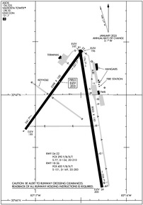
KVLD Airport Diagram
VFR Chart of KVLD
Sectional Charts at SkyVector.com
IFR Chart of KVLD
Enroute Charts at SkyVector.com
Location Information for KVLD
Coordinates: N30°46.89' / W83°16.56'Located 03 miles S of Valdosta, Georgia on 760 acres of land. View all Airports in Georgia.
Surveyed Elevation is 203 feet MSL.
Operations Data
|
|
Airport Communications
| ASOS: | 126.225 Tel. 229-213-0843 |
|---|---|
| VALDOSTA TOWER: | 128.35 |
| VALDOSTA GROUND: | 121.7 |
| VALDOSTA APPROACH: | 126.6 285.6 |
| VALDOSTA DEPARTURE: | 126.6 285.6 |
| IC: | 126.6 285.6 |
| UNICOM: | 122.950 |
| CTAF: | 128.350 |
| ATIS at VAD (12.0 N): | 273.5 |
| AWOS-3PT at 15J (23.3 NW): | 118.025 229-896-4223 |
| AWOS-3 at HOE (30.7 NE): | 118.725 912-487-1253 |
- APCH/DEP SVC PRVDD BY JACKSONVILLE ARTCC ON FREQS 133.7/323.3(VALDOSTA RCAG) WHEN VALDOSTA APCH CTL CLSD.
Nearby Navigation Aids
|
| ||||||||||||||||||||||||||||||||||||||||||||||||||||||||||||


Runway 18/36
| Dimensions: | 8003 x 150 feet / 2439 x 46 meters | |
|---|---|---|
| Surface: | Asphalt / Grooved in Good Condition | |
| Weight Limits: | S-101, D-169, ST-283
PCR VALUE: 400/F/B/X/T
| |
| Edge Lighting: | High Intensity | |
| Runway 18 | Runway 36 | |
| Coordinates: | N30°47.43' / W83°16.51' | N30°46.12' / W83°16.27' |
| Elevation: | 196.5 | 199.7 |
| Traffic Pattern: | Left | Left |
| Runway Heading: | 171° True | 351° True |
| Declared Distances: | TORA:8002 TODA:8002 ASDA:8002 LDA:8002 | TORA:8002 TODA:8002 ASDA:8002 LDA:8002 |
| Markings: | Precision Instrument in good condition. | Precision Instrument in good condition. |
| Glide Slope Indicator | P4L (3.00° Glide Path Angle) | P4L (3.00° Glide Path Angle) |
| Approach Lights: | MALSR 1,400 Foot Medium-intensity Approach Lighting System with runway alignment indicator lights. | |
| REIL: | Yes | |
| Obstacles: | 55 ft Trees 1875 ft from runway, 60 ft right of center | 56 ft Trees 3000 ft from runway, 875 ft left of center |
Runway 04/22
| Dimensions: | 5598 x 100 feet / 1706 x 30 meters | |
|---|---|---|
| Surface: | Asphalt / Grooved in Fair Condition | |
| Weight Limits: | S-77, D-124, ST-210
PCR VALUE: 290/F/B/X/T
| |
| Edge Lighting: | Medium Intensity | |
| Runway 04 | Runway 22 | |
| Coordinates: | N30°46.67' / W83°17.11' | N30°47.42' / W83°16.48' |
| Elevation: | 198.9 | 196.3 |
| Traffic Pattern: | Left | Left |
| Runway Heading: | 36° True | 216° True |
| Declared Distances: | TORA:5598 TODA:5598 ASDA:5598 LDA:5598 | TORA:5598 TODA:5598 ASDA:5598 LDA:5598 |
| Markings: | Non-Precision Instrument in fair condition. | Non-Precision Instrument in fair condition. |
| Glide Slope Indicator | P4L (3.25° Glide Path Angle) | P4L (3.25° Glide Path Angle) |
| REIL: | Yes | Yes |
| Obstacles: | 7 ft Trees 300 ft from runway, 70 ft right of center | 48 ft Trees 1175 ft from runway, 320 ft left of center |
Services Available
| Fuel: | 100LL (blue), Jet A-1+ |
|---|---|
| Transient Storage: | Hangars,Tiedowns |
| Airframe Repair: | MAJOR |
| Engine Repair: | MAJOR |
| Bottled Oxygen: | NONE |
| Bulk Oxygen: | NONE |
| Other Services: | AIR AMBULANCE SERVICES,PILOT INSTRUCTION,AIRCRAFT RENTAL |
Ownership Information
| Ownership: | Publicly owned | |
|---|---|---|
| Owner: | VALDOSTA-LOWNDES CTY APT AUTH | |
| 1750 ARPT RD, SUITE 1 | ||
| VALDOSTA, GA 31601 | ||
| 229-333-1833 | ||
| Manager: | TIM HOOD | |
| 1750 AIRPORT RD, SUITE 1 | ||
| VALDOSTA, GA 31601 | ||
| 229-333-1833 | ||
Other Remarks
- RWY 04/22 HAS 10 FT PAVED SHOULDERS WITH VEGETATION.
- PILOTS MUST SUP OWN TIE-DOWN ROPES.
- WHEN ATCT CLSD ACTVT MALSR RWY 36; REIL RWY 18; PAPI RWY 18 & 36; HIRL RWY 18/36 - CTAF. REIL RWY 04/22; PAPI RWY 04 & 22; MIRL RWY 04/22 UNAVBL WHEN ATCT CLSD.
Weather Minimums


Instrument Approach Procedure (IAP) Charts
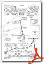
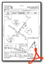


Nearby Airports with Instrument Procedures
| ID | Name | Heading / Distance | ||
|---|---|---|---|---|
 |
KVAD | Moody AFB Airport | 020° | 12.0 |
|
4J5 | Quitman Brooks County Airport | 275° | 16.2 |
|
15J | Cook County Airport | 336° | 23.2 |
|
4J2 | Berrien County Airport | 005° | 25.9 |
|
KHOE | Homerville Airport | 057° | 30.7 |
|
24J | Suwannee County Airport | 155° | 31.6 |
|
KTVI | Thomasville Regional Airport | 283° | 32.1 |
|
KMGR | Moultrie Municipal Airport | 303° | 32.7 |
|
KTMA | Henry Tift Myers Airport | 344° | 40.3 |
|
KFPY | Perry-Foley Airport | 200° | 45.4 |
|
70J | Cairo-Grady County Airport | 278° | 45.8 |
|
KDQH | Douglas Municipal Airport | 027° | 46.8 |
Airport Images

By: chabrier


Comments
Outstanding Service