Login
Register


24J
Suwannee County Airport
Official FAA Data Effective 2026-02-19 0901Z
Chart Supplement

VFR Chart of 24J
Sectional Charts at SkyVector.com
IFR Chart of 24J
Enroute Charts at SkyVector.com
Location Information for 24J
Coordinates: N30°18.02' / W83°1.46'Located 02 miles W of Live Oak, Florida on 183 acres of land. View all Airports in Florida.
Surveyed Elevation is 103 feet MSL.
TPA: 1197 FT AGL PROP, 1697 FT AGL TBJT.
Operations Data
|
|
Airport Communications
| AWOS-3: | 118.225 Tel. 386-362-1731 |
|---|---|
| UNICOM: | 122.800 |
| CTAF: | 122.800 |
| AWOS-3 at LCQ (24.3 E): | 120.675 386-754-9366 |
| ASOS at VLD (31.3 NW): | 126.225 229-213-0843 |
| AWOS-3PT at FPY (31.6 SW): | 118.375 850-838-3526 |
- APCH/DEP SVC PRVDD BY JACKSONVILLE ARTCC ON FREQS 125.375/254.325 (LAKE CITY RCAG).
Nearby Navigation Aids
|
| ||||||||||||||||||||||||||||||||||||||||||||||||||||||||||||


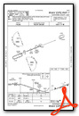
Runway 07/25
| Dimensions: | 4005 x 75 feet / 1221 x 23 meters | |
|---|---|---|
| Surface: | Asphalt in Fair Condition | |
| Weight Limits: | 30 /F/A/W/T, S-83, D-126 | |
| Edge Lighting: | Medium Intensity | |
| Runway 07 | Runway 25 | |
| Coordinates: | N30°17.91' / W83°1.82' | N30°18.14' / W83°1.11' |
| Elevation: | 101.2 | 103.3 |
| Traffic Pattern: | Left | Right |
| Runway Heading: | 69° True | 249° True |
| Markings: | Non-Precision Instrument in fair condition. | Non-Precision Instrument in fair condition. |
| Glide Slope Indicator | P2L (3.00° Glide Path Angle) | P2L (3.00° Glide Path Angle) |
| REIL: | Yes | Yes |
| Obstacles: | 66 ft Trees 1735 ft from runway, 140 ft left of center | 47 ft Trees 1800 ft from runway, 260 ft left of center |
Services Available
| Fuel: | 100LL (blue), Jet-A, Jet A+ |
|---|---|
| Transient Storage: | Tiedowns |
| Airframe Repair: | MAJOR |
| Engine Repair: | MAJOR |
| Bottled Oxygen: | NONE |
| Bulk Oxygen: | NONE |
| Other Services: | CROP DUSTING SERVICES,AIR AMBULANCE SERVICES,PILOT INSTRUCTION |
Ownership Information
| Ownership: | Publicly owned | |
|---|---|---|
| Owner: | SUWANNEE COUNTY | |
| 13150 80TH TER | ||
| LIVE OAK, FL 32064 | ||
| 386-364-3400 | ||
| Manager: | JOHN DUHAIME | |
| 13302 80TH TER | ||
| LIVE OAK, FL 32060 | ||
| 386-362-4200 | ||
Other Remarks
- FOR CD CTC JACKSONVILLE ARTCC AT 904-845-1592.
- ACTVT REIL RWY 07 & 25; PAPI RWY 07 & 25; MIRL RWY 07/25 - CTAF.
- TPA: 1197 FT AGL PROP, 1697 FT AGL TBJT.
Weather Minimums

Instrument Approach Procedure (IAP) Charts

Nearby Airports with Instrument Procedures
| ID | Name | Heading / Distance | ||
|---|---|---|---|---|
 |
KLCQ | Lake City Gateway Airport | 106° | 24.3 |
|
KVLD | Valdosta Regional Airport | 335° | 31.6 |
|
KFPY | Perry-Foley Airport | 244° | 32.1 |
|
KCTY | Cross City Airport | 186° | 40.0 |
|
KVAD | Moody AFB Airport | 347° | 40.9 |
|
4J5 | Quitman Brooks County Airport | 316° | 42.1 |
|
KHOE | Homerville Airport | 015° | 47.1 |
|
KGNV | Gainesville Regional Airport | 132° | 53.6 |
|
15J | Cook County Airport | 336° | 54.8 |
|
4J2 | Berrien County Airport | 349° | 55.6 |
|
KTVI | Thomasville Regional Airport | 309° | 57.1 |
|
42J | Keystone Heights Airport | 117° | 57.7 |
Airport Images
Do you have a recent image of this airport? Upload it here!


