Login
Register


VVS
Joseph A Hardy Connellsville Airport
Official FAA Data Effective 2026-02-19 0901Z
Chart Supplement

VFR Chart of KVVS
Sectional Charts at SkyVector.com
IFR Chart of KVVS
Enroute Charts at SkyVector.com
Location Information for KVVS
Coordinates: N39°57.54' / W79°39.45'Located 05 miles SW of Connellsville, Pennsylvania on 351 acres of land. View all Airports in Pennsylvania.
Surveyed Elevation is 1264 feet MSL.
Operations Data
|
|
Airport Communications
| AWOS-3P: | 133.325 Tel. 724-626-8745 |
|---|---|
| CLARKSBURG APPROACH: | 119.425 284.65 |
| CLARKSBURG DEPARTURE: | 119.425 284.65 |
| CTAF: | 122.800 |
| UNICOM: | 122.800 |
| AWOS-3 at FWQ (17.2 NW): | 118.475 724-379-5815 |
| ATIS at LBE (22.0 NE): | 118.375 |
| ASOS at MGW (22.2 SW): | 120.675 304-371-2021 |
- APCH/DEP SVC PRVDD BY CLEVELAND ARTCC (ZOB) ON FREQS 124.4/327.1 (ALTOONA RCAG) WHEN CLARKSBURG APCH CTL CLSD.
Nearby Navigation Aids
|
| ||||||||||||||||||||||||||||||||||||||||||||||||||||||||||||


Runway 05/23
| Dimensions: | 3833 x 100 feet / 1168 x 30 meters | |
|---|---|---|
| Surface: | Asphalt in Fair Condition | |
| Weight Limits: | S-12 | |
| Edge Lighting: | Medium Intensity | |
| Runway 05 | Runway 23 | |
| Coordinates: | N39°57.41' / W79°39.74' | N39°57.88' / W79°39.21' |
| Elevation: | 1219.6 | 1264.4 |
| Traffic Pattern: | Left | Left |
| Runway Heading: | 41° True | 221° True |
| Markings: | Non-Precision Instrument in good condition. | Basic in good condition. |
| Glide Slope Indicator | P2L (3.00° Glide Path Angle) | P2R (3.00° Glide Path Angle) |
| REIL: | Yes | |
Runway 14/32
| Dimensions: | 2404 x 100 feet / 733 x 30 meters | |
|---|---|---|
| Surface: | Asphalt in Fair Condition | |
| Weight Limits: | S-12 | |
| Edge Lighting: | Medium Intensity THLD & EDGE LGT OTS INDEF. | |
| Runway 14 | Runway 32 | |
| Coordinates: | N39°57.51' / W79°39.60' | N39°57.25' / W79°39.21' |
| Elevation: | 1227.5 | 1236.4 |
| Traffic Pattern: | Left | Left |
| Runway Heading: | 131° True | 311° True |
| Markings: | Basic in good condition. | Basic in good condition. |
| Glide Slope Indicator | P2L (3.00° Glide Path Angle) PAPI OTS INDEF. | |
| Obstacles: | 48 ft Trees 999 ft from runway, 128 ft right of center | 13 ft Trees 339 ft from runway, 110 ft left of center |
Services Available
| Fuel: | 100LL (blue), Jet-A |
|---|---|
| Transient Storage: | Hangars,Tiedowns |
| Airframe Repair: | MAJOR |
| Engine Repair: | MAJOR |
| Bottled Oxygen: | NOT AVAILABLE |
| Bulk Oxygen: | NOT AVAILABLE |
| Other Services: | AIR AMBULANCE SERVICES,AIRCRAFT RENTAL |
Ownership Information
| Ownership: | Publicly owned | |
|---|---|---|
| Owner: | FAYETTE COUNTY AIRPORT AUTHORITY | |
| 988 SKY DRIVE | ||
| LEMONT FURNACE, PA 15456 | ||
| 724-628-2276 | ||
| Manager: | JOHN NECKERAUER | |
| 988 SKY DRIVE | ||
| LEMONT FURNACE, PA 15456 | ||
| 724-628-2276 | AFT HRS 412-916-6282. | |
Other Remarks
- RWY 23 HAS A 265 FT RELOCATED THR FOR TAXI ONLY. RWY 14 HAS A 315 FT RELOCATED THR FOR TAXI ONLY, RWY 32 HAS A 260 FT RELOCATED THR FOR TAXI ONLY.
- DEER & BIRDS ON & INVOF ARPT.
- TWY B CLSD TO ACFT WITH WINGSPAN MORE THAN 40 FT.
- FOR CD CTC CLARKSBURG APCH AT 304-842-2011, WHEN APCH CLSD CTC CLEVELAND ARTCC AT 440-774-0226.
- RWY 14/32: CLSD SS TO SR.
- 0LL SELF SVC 100LL AVBL 24 HRS; CREDIT CARD ONLY.
- ACTVT REIL RWY 05; PAPI RWY 05, 23 & 14. MIRL RWY 05/23 & 14/32 - CTAF.
Weather Minimums
Instrument Approach Procedure (IAP) Charts

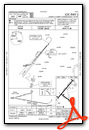
Nearby Airports with Instrument Procedures
| ID | Name | Heading / Distance | ||
|---|---|---|---|---|
 |
KFWQ | Rostraver Airport | 331° | 17.0 |
|
KLBE | Arnold Palmer Regional Airport | 031° | 22.0 |
|
KWAY | Greene County Airport | 261° | 22.1 |
|
KMGW | Morgantown Municipal/Walter L Bill Hart Field Airport | 212° | 22.4 |
|
G05 | Finleyville Airpark Airport | 316° | 23.6 |
|
KAGC | Allegheny County Airport | 332° | 26.8 |
|
2G4 | Garrett County Airport | 146° | 27.1 |
|
2G9 | Somerset County Airport | 080° | 30.0 |
|
KAFJ | Washington County Airport | 290° | 31.0 |
|
4G7 | Fairmont Municipal-Frankman Field Airport | 217° | 38.7 |
|
KPIT | Pittsburgh International Airport | 320° | 41.4 |
|
KJST | John Murtha Johnstown/Cambria County Airport | 060° | 43.5 |


