Login
Register


AGC
Allegheny County Airport
Official FAA Data Effective 2026-01-22 0901Z
Chart Supplement

KAGC Airport Diagram

VFR Chart of KAGC
Sectional Charts at SkyVector.com
IFR Chart of KAGC
Enroute Charts at SkyVector.com
Location Information for KAGC
Coordinates: N40°21.27' / W79°55.74'Located 04 miles SE of Pittsburgh, Pennsylvania on 432 acres of land. View all Airports in Pennsylvania.
Surveyed Elevation is 1251 feet MSL.
Operations Data
|
|
Airport Communications
| ATIS: | 120.55 |
|---|---|
| ASOS: | 120.55 Tel. 412-466-8968 |
| ALLEGHENY TOWER: | 121.1 239.0 |
| ALLEGHENY GROUND: | 121.7 |
| PITTSBURGH APPROACH: | 119.35 285.575 337.4 |
| PITTSBURGH DEPARTURE: | 119.35 285.575 337.4 |
| UNICOM: | 122.950 |
| CLASS B: | 119.35 285.575 337.4 |
| AWOS-A at 42PN (7.0 NW): | 412-442-2213 |
| AWOS-3 at FWQ (9.7 SE): | 118.475 724-379-5815 |
| ASOS at PIT (14.9 NW): | 215-798-0218 |
Nearby Navigation Aids
|
| ||||||||||||||||||||||||||||||||||||||||||||||||||||||||||||


Runway 10/28
| Dimensions: | 6501 x 150 feet / 1982 x 46 meters | |
|---|---|---|
| Surface: | Concrete / Grooved in Good Condition | |
| Weight Limits: | S-90, D-120, ST-210 | |
| Edge Lighting: | High Intensity | |
| Runway 10 | Runway 28 | |
| Coordinates: | N40°21.26' / W79°56.47' | N40°21.26' / W79°55.07' |
| Elevation: | 1249.4 | 1250.0 |
| Traffic Pattern: | Left | Left |
| Runway Heading: | 90° True | 270° True |
| Markings: | Precision Instrument in good condition. | Precision Instrument in good condition. |
| Glide Slope Indicator | V4L (3.00° Glide Path Angle) | |
| RVR Equipment | Rollout | Touchdown |
| Approach Lights: | MALS 1,400 Foot Medium-intensity Approach Lighting System. | |
| REIL: | Yes | |
| Obstacles: | 63 ft Trees 2613 ft from runway, 433 ft left of center | |
Runway 13/31
| Dimensions: | 3825 x 100 feet / 1166 x 30 meters | |
|---|---|---|
| Surface: | Concrete / Grooved in Good Condition | |
| Weight Limits: | S-20, D-22 | |
| Edge Lighting: | High Intensity | |
| Runway 13 | Runway 31 | |
| Coordinates: | N40°21.44' / W79°56.06' | N40°21.12' / W79°55.35' |
| Elevation: | 1245.2 | 1248.6 |
| Traffic Pattern: | Left | Left |
| Runway Heading: | 120° True | 300° True |
| Markings: | Basic in good condition. | Basic in good condition. |
| REIL: | Yes | Yes |
Helipad H1
HELIPAD LCTD ON GA APN E OF TWY C. | ||
| Dimensions: | 47 x 45 feet / 14 x 14 meters | |
|---|---|---|
| Surface: | Concrete in Good Condition | |
| Coordinates: | N40°21.19' / W79°55.81' | N0°0.00' / E0°0.00' |
| Elevation: | 1255.0 | |
| Markings: | Basic in good condition. | |
Services Available
| Fuel: | 100LL (blue), Jet-A, Jet A+ |
|---|---|
| Transient Storage: | Hangars,Tiedowns |
| Airframe Repair: | MAJOR |
| Engine Repair: | MAJOR |
| Bottled Oxygen: | HIGH/LOW |
| Bulk Oxygen: | HIGH/LOW |
| Other Services: | AIR FREIGHT SERVICES,AIR AMBULANCE SERVICES,AVIONICS,CARGO HANDLING SERVICES,CHARTER SERVICE,PILOT INSTRUCTION |
Ownership Information
| Ownership: | Publicly owned | |
|---|---|---|
| Owner: | ALLEGHENY CO ARPT AUTHORITY | |
| PO BOX 12370 | ||
| PITTSBURGH, PA 15231-0370 | ||
| 412-472-3500 | ||
| Manager: | LANCE BAGNOFF | |
| 12 ALLEGHENY COUNTY AIRPORT | ||
| WEST MIFFLIN, PA 15122-2656 | ||
| 412-472-5839 | ||
Other Remarks
- BIRDS & DEER ON & INVOF ARPT.
- APN MAIN TRML RAMP PRKG 12HR PPR 412-759-7897.
- JET A ANTI-ICE AVBL ON REQ.
- ATC-CTL.
Weather Minimums

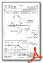
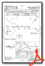
Instrument Approach Procedure (IAP) Charts

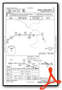
Departure Procedure (DP) Charts
Nearby Airports with Instrument Procedures
| ID | Name | Heading / Distance | ||
|---|---|---|---|---|
 |
G05 | Finleyville Airpark Airport | 209° | 7.5 |
|
KFWQ | Rostraver Airport | 152° | 9.8 |
|
KPIT | Pittsburgh International Airport | 300° | 16.2 |
|
KAFJ | Washington County Airport | 231° | 21.1 |
|
KLBE | Arnold Palmer Regional Airport | 101° | 24.3 |
|
KBTP | Pittsburgh/Butler Regional Airport | 357° | 25.3 |
|
KVVS | Joseph A Hardy Connellsville Airport | 152° | 26.8 |
|
6P7 | Mcville Airport | 033° | 27.4 |
|
KWAY | Greene County Airport | 198° | 28.7 |
|
KPJC | Zelienople Municipal Airport | 338° | 28.9 |
|
KBVI | Beaver County Airport | 319° | 32.8 |
|
KHLG | Wheeling Ohio County Airport | 252° | 34.7 |
Airport Images
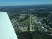
By: kbar63


