Login
Register


LBE
Arnold Palmer Regional Airport
Official FAA Data Effective 2025-11-27 0901Z
Chart Supplement

KLBE Airport Diagram

VFR Chart of KLBE
Sectional Charts at SkyVector.com
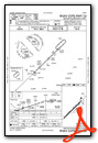
IFR Chart of KLBE
Enroute Charts at SkyVector.com
Location Information for KLBE
Coordinates: N40°16.39' / W79°24.62'Located 02 miles SW of Latrobe, Pennsylvania on 945 acres of land. View all Airports in Pennsylvania.
Surveyed Elevation is 1198 feet MSL.
Operations Data
|
|
Airport Communications
| ATIS: | 118.375 ((724) 539-0671) |
|---|---|
| AWOS-3: | Tel. 724-537-0671 |
| PALMER TOWER: | 125.0 |
| PALMER GROUND: | 121.8 |
| JOHNSTOWN APPROACH: | 121.2 299.2 |
| JOHNSTOWN DEPARTURE: | 121.2 299.2 |
| EMERG: | 121.5 |
| CTAF: | 125.000 |
| AWOS-3 at FWQ (19.8 W): | 118.475 724-379-5815 |
| AWOS-3P at VVS (22.0 SW): | 133.325 724-626-8745 |
| AWOS-3P at 2G9 (22.9 SE): | 133.8 814-443-2114 |
- APCH/DEP SVC PRVDD BY CLEVELAND ARTCC (ZOB) ON FREQS 124.4/327.1 (ALTOONA RCAG) WHEN JOHNSTOWN APCH CTL CLSD.
- ATIS FREQ 118.375 USED TO TMT AWOS WX DATA WHEN ATCT CLSD.
Nearby Navigation Aids
|
| ||||||||||||||||||||||||||||||||||||||||||||||||||||||||||||


Runway 06/24
| Dimensions: | 8222 x 150 feet / 2506 x 46 meters | |
|---|---|---|
| Surface: | Asphalt / Grooved in Excellent Condition | |
| Weight Limits: | S-120, D-198, ST-321
PCR VALUE: 490/F/B/X/U
| |
| Edge Lighting: | High Intensity | |
| Runway 06 | Runway 24 | |
| Coordinates: | N40°15.91' / W79°25.25' | N40°16.86' / W79°23.99' |
| Elevation: | 1198.7 | 1135.2 |
| Traffic Pattern: | Right | |
| Runway Heading: | 46° True | 226° True |
| Displaced Threshold: | 850 Feet | |
| Declared Distances: | TORA:8222 TODA:8222 ASDA:8222 LDA:8222 | TORA:8222 TODA:8222 ASDA:8222 LDA:7372 |
| Markings: | Non-Precision Instrument in good condition. | Precision Instrument in good condition. |
| Glide Slope Indicator | P4L (3.00° Glide Path Angle) | P4L (3.00° Glide Path Angle) RWY 24 PAPI UNUSBL BYD 8 DEGS RIGHT OF CNTRLN. |
| Approach Lights: | MALSR 1,400 Foot Medium-intensity Approach Lighting System with runway alignment indicator lights. | |
| REIL: | Yes | |
| Obstacles: | 41 ft Pole 762 ft from runway, 538 ft right of center | 58 ft Trees 2043 ft from runway, 218 ft right of center |
Services Available
| Fuel: | 100LL (blue), Jet-A |
|---|---|
| Transient Storage: | Hangars,Tiedowns |
| Airframe Repair: | MAJOR |
| Engine Repair: | MAJOR |
| Bottled Oxygen: | HIGH |
| Bulk Oxygen: | NONE |
| Other Services: | AVIONICS,CHARTER SERVICE,PILOT INSTRUCTION,AIRCRAFT RENTAL,AIRCRAFT SALES |
Ownership Information
| Ownership: | Publicly owned | |
|---|---|---|
| Owner: | WESTMORELAND COUNTY ARPT AUTH | |
| 148 AVIATION LANE, SUITE 103 | ||
| LATROBE, PA 15650-9549 | ||
| 724-640-7234 | ||
| Manager: | GABE MONZO | |
| 148 AVIATION LANE, SUITE 103 | ||
| LATROBE, PA 15650-9549 | ||
| 724-539-8100 | ||
Other Remarks
- DEER & BIRDS ON & INVOF ARPT.
- FOR CD WHEN ATCT CLSD CTC JOHNSTOWN APCH AT 814-532-5960, WHEN APCH CLSD CTC CLEVELAND ARTCC AT 440-774-0213.
- WHEN ATCT CLSD, ACTVT MALSR RWY 24; REIL RWY 06; HIRL RWY 06/24; TWY A, B, C & D - CTAF.
Weather Minimums

Instrument Approach Procedure (IAP) Charts


Nearby Airports with Instrument Procedures
| ID | Name | Heading / Distance | ||
|---|---|---|---|---|
 |
KFWQ | Rostraver Airport | 259° | 19.7 |
|
KVVS | Joseph A Hardy Connellsville Airport | 211° | 22.0 |
|
2G9 | Somerset County Airport | 127° | 23.0 |
|
KAGC | Allegheny County Airport | 281° | 24.3 |
|
KIDI | Indiana County/Jimmy Stewart Field Airport | 033° | 25.7 |
|
KJST | John Murtha Johnstown/Cambria County Airport | 084° | 26.6 |
|
G05 | Finleyville Airpark Airport | 266° | 27.6 |
|
6P7 | Mcville Airport | 343° | 28.9 |
|
9G8 | Ebensburg Airport | 068° | 31.2 |
|
KBTP | Pittsburgh/Butler Regional Airport | 320° | 39.0 |
|
KPIT | Pittsburgh International Airport | 289° | 39.9 |
|
KWAY | Greene County Airport | 236° | 40.0 |


")


