Login
Register


BTP
Pittsburgh/Butler Regional Airport
Official FAA Data Effective 2026-02-19 0901Z
Chart Supplement

VFR Chart of KBTP
Sectional Charts at SkyVector.com
IFR Chart of KBTP
Enroute Charts at SkyVector.com
Location Information for KBTP
Coordinates: N40°46.59' / W79°57.06'Located 05 miles SW of Butler, Pennsylvania on 304 acres of land. View all Airports in Pennsylvania.
Surveyed Elevation is 1248 feet MSL.
Operations Data
|
|
Airport Communications
| AWOS-3PT: | 121.450 Tel. 724-586-6434 |
|---|---|
| PITTSBURGH APPROACH: | 124.75 338.2 |
| PITTSBURGH DEPARTURE: | 124.75 338.2 |
| CLEARANCE DELIVERY: | 119.4 |
| CLASS B: | 124.75 338.2 |
| CTAF: | 123.050 |
| UNICOM: | 123.050 |
| AWOS-3PT at PJC (9.7 W): | 118.45 724-452-5304 |
| AWOS-A at 42PN (19.4 S): | 412-442-2213 |
| AWOS-3PT at BVI (20.0 W): | 118.35 724-843-1024 |
- COMMUNICATIONS PRVDD BY ALTOONA RADIO ON FREQS 122.1R/115.8T (ELLWOOD CITY RCO).
Nearby Navigation Aids
|
| ||||||||||||||||||||||||||||||||||||||||||||||||||||||||||||


Runway 08/26
| Dimensions: | 4801 x 100 feet / 1463 x 30 meters | |
|---|---|---|
| Surface: | Asphalt / Grooved in Good Condition | |
| Weight Limits: | S-37, D-50 | |
| Edge Lighting: | High Intensity | |
| Runway 08 | Runway 26 | |
| Coordinates: | N40°46.47' / W79°57.56' | N40°46.72' / W79°56.57' |
| Elevation: | 1227.7 | 1243.2 |
| Traffic Pattern: | Left | Left |
| Runway Heading: | 72° True | 252° True |
| Markings: | Precision Instrument in good condition. | Non-Precision Instrument in good condition. |
| Glide Slope Indicator | P4L (3.00° Glide Path Angle) | P4L (3.50° Glide Path Angle) |
| Approach Lights: | MALSF 1,400 Foot Medium-intensity Approach Lighting System with sequenced flashers. | |
| REIL: | Yes | |
| Obstacles: | 52 ft Trees 957 ft from runway, 574 ft right of center | 38 ft Trees 819 ft from runway, 11 ft left of center RWY 26 PUB ROAD AT THR 455 FT RIGHT. |
Services Available
| Fuel: | 100LL (blue), Jet-A, Jet A+ |
|---|---|
| Transient Storage: | Hangars,Tiedowns |
| Airframe Repair: | MAJOR |
| Engine Repair: | MAJOR |
| Bottled Oxygen: | NONE |
| Bulk Oxygen: | HIGH/LOW |
| Other Services: | AIR FREIGHT SERVICES,AIR AMBULANCE SERVICES,AVIONICS,CARGO HANDLING SERVICES,CHARTER SERVICE,PILOT INSTRUCTION,AIRCRAFT RENTAL,AIRCRAFT SALES |
Ownership Information
| Ownership: | Publicly owned | |
|---|---|---|
| Owner: | BUTLER CO ARPT AUTH | |
| 473 AIRPORT RD, SUITE 2 | ||
| BUTLER, PA 16002 | ||
| 724-586-6665 | ||
| Manager: | STEPHANIE SARACCO | |
| 473 AIRPORT RD, SUITE 2 | ||
| BUTLER, PA 16002 | ||
| 724-586-6665 | ||
Other Remarks
- THIS AIRPORT HAS BEEN SURVEYED BY THE NATIONAL GEODETIC SURVEY.
- NOISE ABATEMENT PROC IN EFCT; CMB TO 2000 FT BFR TURNING.
- DEER AND BIRDS ON AND INVOF ARPT.
- ARPT OFC HRS 0800-1630 M-F, CLSD HOLS.
- 0LL 100LL SELF-SERVE AVBL.
- ACTVT MALSF RWY 08; REIL RWY 26; PAPI RWY 08 & 26; HIRL RWY 08/26 - CTAF.
Weather Minimums

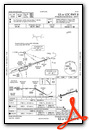
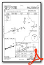
Instrument Approach Procedure (IAP) Charts

Nearby Airports with Instrument Procedures
| ID | Name | Heading / Distance | ||
|---|---|---|---|---|
 |
KPJC | Zelienople Municipal Airport | 279° | 9.7 |
|
6P7 | Mcville Airport | 098° | 16.4 |
|
KBVI | Beaver County Airport | 269° | 20.1 |
|
KPIT | Pittsburgh International Airport | 217° | 21.4 |
|
29D | Grove City Airport | 336° | 24.2 |
|
KAGC | Allegheny County Airport | 177° | 25.3 |
|
KUCP | New Castle Municipal Airport | 305° | 25.8 |
|
G05 | Finleyville Airpark Airport | 184° | 32.0 |
|
02G | Columbiana County Airport | 259° | 32.1 |
|
KFWQ | Rostraver Airport | 170° | 34.4 |
|
4G4 | Youngstown Elser Metro Airport | 288° | 34.9 |
|
KAXQ | Clarion County Airport | 040° | 35.5 |


Comments
Self Service Fuel @ BTP
Self Service 100LL Fuel is now available @ $5.20/gal.
Pages