Login
Register


LMT
Crater Lake/Klamath Regional Airport
Official FAA Data Effective 2025-11-27 0901Z
Chart Supplement

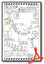
KLMT Airport Diagram

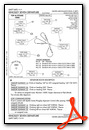
VFR Chart of KLMT
Sectional Charts at SkyVector.com
IFR Chart of KLMT
Enroute Charts at SkyVector.com
Location Information for KLMT
Coordinates: N42°9.37' / W121°44.00'Located 04 miles SE of Klamath Falls, Oregon on 1251 acres of land. View all Airports in Oregon.
Surveyed Elevation is 4095 feet MSL.
Operations Data
|
|
Airport Communications
| ATIS: | 126.5 263.0 |
|---|---|
| ASOS: | Tel. 541-883-8127 |
| KINGSLEY TOWER: | 133.975 257.8 |
| KINGSLEY GROUND: | 121.9 348.6 |
| KINGSLEY APPROACH: | 123.675 270.8 |
| KINGSLEY DEPARTURE: | 123.675 270.8 |
| COMD POST: | 298.4 |
| ANG OPS: | 388.95 |
| UNICOM: | 122.950 |
| EMERG: | 121.5 |
| CTAF: | 133.975 |
| ASOS at SIY (40.0 SW): | 121.125 530-459-0267 |
| ATIS at MFR (52.3 W): | 127.25 |
| ASOS at MFR (52.7 W): | 127.25 541-204-0136 |
- APCH/DEP CTL SVC PRVDD BY SEATTLE ARTCC (ZSE) ON FREQS 127.6/346.35 (KLAMATH FALLS RCAG) WHEN KINGSLEY APCH (LMT) CLSD.
- ATCT MAY OPERATE AT OTHER TIMES BY NOTAM AS REQUIRED FOR MILITARY ACTIVITIES.
Nearby Navigation Aids
|
| ||||||||||||||||||||||||||||||||||||||||||


Runway 14/32
| Dimensions: | 10302 x 150 feet / 3140 x 46 meters | |
|---|---|---|
| Surface: | Asphalt-Concrete / Grooved in Good Condition | |
| Weight Limits: | S-120, D-243, ST-474, DT-970
PCR VALUE: 560/F/A/W/T
| |
| Edge Lighting: | High Intensity | |
| Runway 14 | Runway 32 | |
| Coordinates: | N42°10.15' / W121°44.42' | N42°8.58' / W121°43.58' |
| Elevation: | 4091.0 | 4095.4 |
| Traffic Pattern: | Left | Left |
| Runway Heading: | 158° True | 338° True |
| Declared Distances: | TORA:10302 TODA:10302 ASDA:10302 LDA:10302 | TORA:10302 TODA:10302 ASDA:10302 LDA:10302 |
| Markings: | Precision Instrument in good condition. | Precision Instrument in fair condition. |
| Glide Slope Indicator | P4L (3.20° Glide Path Angle) RWY 14 PAPI UNUSBL BYD 3.5 NM. | V4L (3.00° Glide Path Angle) |
| RVR Equipment | Rollout | Touchdown |
| Approach Lights: | MALSF 1,400 Foot Medium-intensity Approach Lighting System with sequenced flashers. | MALSR 1,400 Foot Medium-intensity Approach Lighting System with runway alignment indicator lights. |
Runway 08/26
| Dimensions: | 5001 x 75 feet / 1524 x 23 meters | |
|---|---|---|
| Surface: | Asphalt / Grooved in Good Condition | |
| Weight Limits: | S-41, D-68, ST-116
PCR VALUE: 110/F/A/X/T
| |
| Edge Lighting: | Medium Intensity | |
| Runway 08 | Runway 26 | |
| Coordinates: | N42°9.38' / W121°44.56' | N42°9.37' / W121°43.45' |
| Elevation: | 4092.2 | 4089.3 |
| Traffic Pattern: | Left | Left |
| Runway Heading: | 90° True | 270° True |
| Declared Distances: | TORA:5001 TODA:5001 ASDA:5001 LDA:5001 | TORA:5001 TODA:5001 ASDA:5001 LDA:5001 |
| Markings: | Non-Precision Instrument in good condition. | Non-Precision Instrument in good condition. |
| Glide Slope Indicator | P4L (3.00° Glide Path Angle) | |
| REIL: | Yes | |
| Obstacles: | 25 ft Railroad 625 ft from runway, 125 ft right of center APCH SLOPE 29:1 TO DTHR. |
8 ft Fence 86 ft from runway, 125 ft right of center APCH SLOPE 34:1 TO DTHR. |
Services Available
| Fuel: | 100LL (blue), Jet-A, A++ |
|---|---|
| Transient Storage: | Hangars,Tiedowns |
| Airframe Repair: | MAJOR |
| Engine Repair: | MAJOR |
| Bottled Oxygen: | HIGH |
| Bulk Oxygen: | HIGH |
| Other Services: | AIR FREIGHT SERVICES,CROP DUSTING SERVICES,CARGO HANDLING SERVICES,CHARTER SERVICE,PILOT INSTRUCTION |
Ownership Information
| Ownership: | Publicly owned | |
|---|---|---|
| Owner: | CITY OF KLAMATH FALLS | |
| CITY HALL PO BOX 237 | ||
| KLAMATH FALLS, OR 97601 | ||
| 541-883-5316 | ||
| Manager: | JONATHAN TEICHERT | |
| 3000 AIRPORT WAY STE. 300 | ||
| KLAMATH FALLS, OR 97603 | ||
| 541-883-5373 | 541-539-8977. | |
Other Remarks
- WATERFOWL INVOF ARPT NOV-MAY.
- OFFL BUS PPR - D830-6686. BASE OPS 1400-2359Z++ WKDAYS; CLSD HOL.
- MIL FUEL SVC 1500-0300Z++; 20 MIN PRIOR NOTICE & FEE - C541-882-4681
- MIL BASH PHASE II - FEB - MAY & SEP - NOV. OTR TIMES BASH PHASE I.
- RSTD: TWY A WEST OF TWY D & TWY D BTN TWY E & F MIL OPS ONLY.
- FBO - 541-882-4681.
- TWY G SOUTH RUN UP PAD MIL OPS ONLY.
- CONDS UNMTR WKDAY 2230 - 0630, WKEND & HOL.
- FOR CD IF UNA TO CTC ON FSS FREQ, CTC SEATTLE ARTCC AT 253-351-3694.
- MIL ANG: CLASSIFIED MTRL STORAGE SECRET & BLW - AMGMT.
- TWY B BTN TWY B1 & B2 WINGTIP TO FIXED OBJECT SEPN NONSTD; WINGSPAN GTR THAN 133 FT MINIMIZE TAX SPD.
- MIL ANG: HVY ACFT AFT LNDG TAX TO N OR S EOR; SHTDN OUTBOARD ENGS BFR TAX TO MIL RAMP.
- CSTMS/AG/IMG SVC NA. KPDX CUST - C503-326-3249.
- WHEN ATCT CLSD ACTVT MALSF RWY 14, MALSR RWY 32, HIRL RWY 14/32, MIRL RWY 08/26 & TWY LGTS - CTAF. RWY & TWY LGTS ALSO ACTVT ON 257.8. REIL RWY 26; PAPI RWY 26, PAPI RWY 14 & VASI RWY 32 OPR CONSLY.
- TYPE H BAK-12B(B)(1500')
- TYPE H BAK-12B(B)(1500')
Weather Minimums

Instrument Approach Procedure (IAP) Charts


Departure Procedure (DP) Charts
Departure Procedure Obstacles (DPO) Charts
Nearby Airports with Instrument Procedures
| ID | Name | Heading / Distance | ||
|---|---|---|---|---|
 |
O46 | Weed Airport | 218° | 51.8 |
|
KMFR | Rogue Valley International/Medford Airport | 284° | 52.5 |
|
KLKV | Lake County Airport | 089° | 59.5 |
|
KAAT | Alturas Municipal Airport | 127° | 66.1 |
|
3S8 | Grants Pass Airport | 286° | 76.6 |
|
62S | Christmas Valley Airport | 035° | 80.2 |
|
KRBG | Roseburg Regional Airport | 312° | 96.8 |
|
O85 | Benton Field Airport | 198° | 99.7 |
|
KRDD | Redding Regional Airport | 194° | 102.0 |
|
S21 | Sunriver Airport | 006° | 103.9 |
|
KBOK | Brookings Airport | 268° | 114.3 |
|
KCEC | Jack Mc Namara Field Airport | 259° | 114.3 |
Airport Images
Do you have a recent image of this airport? Upload it here!


