Login
Register


CEC
Jack Mc Namara Field Airport
Official FAA Data Effective 2026-01-22 0901Z
Chart Supplement

VFR Chart of KCEC
Sectional Charts at SkyVector.com
IFR Chart of KCEC
Enroute Charts at SkyVector.com
Location Information for KCEC
Coordinates: N41°46.81' / W124°14.19'Located 03 miles NW of Crescent City, California on 544 acres of land. View all Airports in California.
Surveyed Elevation is 60 feet MSL.
Operations Data
|
|
Airport Communications
| ASOS: | 119.925 Tel. 707-465-5458 |
|---|---|
| CTAF: | 122.800 |
| UNICOM: | 122.800 |
| AWOS-3PT at BOK (17.9 N): | 132.025 541-412-8682 |
| AWOS-3PT at 4S1 (39.1 N): | 118.15 541-247-2518 |
| ASOS at ACV (48.4 S): | 118.525 707-839-7429 |
- APCH/DEP CTL SVC PRVDD BY SEATTLE ARTCC (ZSE) ON FREQS 124.85/306.3 (ARCATA RCAG).
Nearby Navigation Aids
|
| ||||||||||||||||||||||||||||||||||||||||||


Runway 12/30
| Dimensions: | 5002 x 150 feet / 1525 x 46 meters | |
|---|---|---|
| Surface: | Asphalt in Fair Condition | |
| Weight Limits: | S-30, D-43
PCR VALUE: 103/F/C/Y/T
| |
| Edge Lighting: | High Intensity | |
| Runway 12 | Runway 30 | |
| Coordinates: | N41°47.10' / W124°14.49' | N41°46.54' / W124°13.69' |
| Elevation: | 56.9 | 53.0 |
| Traffic Pattern: | Left | Left |
| Runway Heading: | 133° True | 313° True |
| Declared Distances: | TORA:5002 TODA:5002 ASDA:5002 LDA:5002 | TORA:5002 TODA:5002 ASDA:5002 LDA:5002 |
| Markings: | Precision Instrument in fair condition. | Precision Instrument in fair condition. |
| Glide Slope Indicator | V4L (3.50° Glide Path Angle) | |
| Approach Lights: | MALSR 1,400 Foot Medium-intensity Approach Lighting System with runway alignment indicator lights. | |
| REIL: | Yes | |
| Obstacles: | 86 ft Trees 1520 ft from runway, 250 ft right of center | |
Runway 18/36
| Dimensions: | 5000 x 150 feet / 1524 x 46 meters | |
|---|---|---|
| Surface: | Asphalt in Fair Condition | |
| Weight Limits: | S-30, D-43
PCR VALUE: 103/F/C/Y/T
| |
| Edge Lighting: | Medium Intensity | |
| Runway 18 | Runway 36 | |
| Coordinates: | N41°47.20' / W124°14.17' | N41°46.40' / W124°14.42' |
| Elevation: | 60.6 | 50.6 |
| Traffic Pattern: | Left | Left |
| Runway Heading: | 193° True | 13° True |
| Displaced Threshold: | 148 Feet | |
| Declared Distances: | TORA:5000 TODA:5000 ASDA:5000 LDA:4850 | TORA:4850 TODA:4850 ASDA:4850 LDA:4850 |
| Markings: | Non-Precision Instrument in fair condition. | Non-Precision Instrument in fair condition. |
| Glide Slope Indicator | V4L (3.00° Glide Path Angle) | |
| REIL: | Yes | Yes |
| Obstacles: | 55 ft Ground 1075 ft from runway, 250 ft right of center | 9 ft Road 350 ft from runway |
Services Available
| Fuel: | 100LL (blue), Jet-A |
|---|---|
| Transient Storage: | Tiedowns |
| Airframe Repair: | MINOR |
| Engine Repair: | MINOR |
| Bottled Oxygen: | NONE |
| Bulk Oxygen: | NONE |
| Other Services: | AIR FREIGHT SERVICES,AIR AMBULANCE SERVICES,CHARTER SERVICE,PILOT INSTRUCTION,AIRCRAFT RENTAL,AIRCRAFT SALES,ANNUAL SURVEYING |
Ownership Information
| Ownership: | Publicly owned | |
|---|---|---|
| Owner: | BORDER COAST REGIONAL ARPT AUTH | |
| 1650 DALE RUPERT ROAD, SUITE 100 | ||
| CRESCENT CITY, CA 95531 | ||
| 707-464-7288 | ||
| Manager: | PATRICIA STANLEY | |
| 1650 DALE RUPERT RD, SUITE 100 | ||
| CRESCENT CITY, CA 95531 | ||
| 707-464-7288 | ||
Other Remarks
- A 150 FT LGTD TWR 3300 FT W CEC VOR.
- BIRDS AND DEER ON & INVOF ARPT.
- RIDGE LNS OF SHIFTING SAND DUNES 30-50 FT AGL AND 1000 FT OFF APCH END RWY 18.
- TSNT PRKG RAMP ESTD WGT LIMIT 20000 LBS, FBO RAMP ESTD WGT LIMIT 60000 LBS.
- FOR CD IF UNA TO CTC ON FSS FREQ, CTC SEATTLE ARTCC AT 253-351-3694.
- ACTVT MALSR RWY 12; REIL RWY 18, 36, & 30; HIRL RWY 12/30; MIRL RWY 18/36 - CTAF.
Weather Minimums


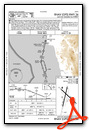
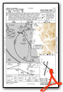
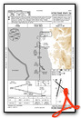
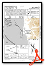
Instrument Approach Procedure (IAP) Charts


Nearby Airports with Instrument Procedures
| ID | Name | Heading / Distance | ||
|---|---|---|---|---|
 |
KBOK | Brookings Airport | 352° | 17.8 |
|
4S1 | Gold Beach Municipal Airport | 347° | 39.0 |
|
KACV | California Redwood Coast-Humboldt County Airport | 173° | 48.5 |
|
3S8 | Grants Pass Airport | 040° | 57.9 |
|
KEKA | Murray Field Airport | 174° | 58.8 |
|
KMFR | Rogue Valley International/Medford Airport | 059° | 70.6 |
|
KFOT | Rohnerville Airport | 176° | 73.7 |
|
O46 | Weed Airport | 102° | 82.2 |
|
KRBG | Roseburg Regional Airport | 023° | 95.8 |
|
KOTH | Southwest Oregon Regional Airport | 359° | 98.2 |
|
O85 | Benton Field Airport | 130° | 110.0 |
|
KLMT | Crater Lake/Klamath Regional Airport | 077° | 114.3 |
Airport Images
Do you have a recent image of this airport? Upload it here!


