Login
Register


O85
Benton Field Airport
Official FAA Data Effective 2026-01-22 0901Z
Chart Supplement

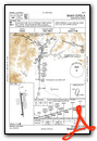
VFR Chart of O85
Sectional Charts at SkyVector.com
IFR Chart of O85
Enroute Charts at SkyVector.com
Location Information for O85
Coordinates: N40°34.42' / W122°24.44'Located 01 miles W of Redding, California on 80 acres of land. View all Airports in California.
Surveyed Elevation is 723 feet MSL.
Operations Data
|
|
Airport Communications
| AWOS-2: | 118.675 Tel. 530-225-4183 |
|---|---|
| UNICOM: | 122.800 |
| CTAF: | 122.800 |
| ATIS at RDD (6.5 SE): | 124.1 |
| ASOS at RDD (6.7 SE): | 530-276-8557 |
| AWOS-3 at O54 (25.6 NW): | 120.850 530-623-3810 |
- APCH/DEP CTL SVC PRVDD BY OAKLAND ARTCC (ZOA) ON 132.2/350.3 (RED BLUFF RCAG).
Nearby Navigation Aids
|
| ||||||||||||||||||||||||||||||||||||


Runway 16/34
| Dimensions: | 2420 x 75 feet / 738 x 23 meters | |
|---|---|---|
| Surface: | Asphalt in Excellent Condition | |
| Weight Limits: | S-12 | |
| Edge Lighting: | Medium Intensity | |
| Runway 16 | Runway 34 | |
| Coordinates: | N40°34.62' / W122°24.47' | N40°34.22' / W122°24.41' |
| Elevation: | 723.2 | 718.9 |
| Traffic Pattern: | Right | Left |
| Runway Heading: | 174° True | 354° True |
| Markings: | Basic in good condition. | Basic in good condition. |
| Glide Slope Indicator | P2L (3.50° Glide Path Angle) | P2L (3.50° Glide Path Angle) |
Services Available
| Fuel: | 100LL (blue), Jet-A |
|---|---|
| Transient Storage: | Tiedowns |
| Airframe Repair: | MAJOR |
| Engine Repair: | MAJOR |
| Bottled Oxygen: | HIGH/LOW |
| Bulk Oxygen: | HIGH/LOW |
| Other Services: | AVIONICS,CHARTER SERVICE,PILOT INSTRUCTION,AIRCRAFT RENTAL,AIRCRAFT SALES |
Ownership Information
| Ownership: | Publicly owned | |
|---|---|---|
| Owner: | CITY OF REDDING | |
| 777 CYPRESS AVE | ||
| REDDING, CA 96001 | ||
| 530-224-4321 | ||
| Manager: | ANDREW SOLSVIG | |
| 6751 WOODRUM CIRCLE, #200 | ||
| REDDING, CA 96002 | ||
| 530-224-4321 | PHONE MGRS OFFICE AT RDD (530) 224-4321. | |
Other Remarks
- LARGE BIRDS FREQUENTLY ON AND IN VICINITY OF ARPT OCT-APR.
- RWY 16/34 HALFWAY DIST MARKERS BOTH SIDES OF RWY.
- FOR NOISE ABATEMENT CLIMB TO 1500 FT AGL BFR TURNING. CALM WIND PREFERRED DRCTN IS RWY 34.
- FOR CD CTC OAKLAND ARTCC AT 510-745-3380.
- ACTVT PAPI RWY 16 & 34; MIRL RWY 16/34 - CTAF.
Weather Minimums

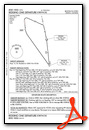
Instrument Approach Procedure (IAP) Charts

Departure Procedure Obstacles (DPO) Charts
Nearby Airports with Instrument Procedures
| ID | Name | Heading / Distance | ||
|---|---|---|---|---|
 |
KRDD | Redding Regional Airport | 126° | 6.5 |
|
KRBL | Red Bluff Municipal Airport | 164° | 26.4 |
|
O37 | Haigh Field Airport | 166° | 52.5 |
|
KCIC | Chico Regional Airport | 151° | 53.1 |
|
O46 | Weed Airport | 357° | 54.4 |
|
O05 | Rogers Field Airport | 107° | 56.2 |
|
KWLW | Willows/Glenn County Airport | 172° | 64.0 |
|
KOVE | Oroville Municipal Airport | 150° | 74.5 |
|
KFOT | Rohnerville Airport | 269° | 78.9 |
|
KEKA | Murray Field Airport | 280° | 79.0 |
|
O28 | Ells Field/Willits Municipal Airport | 213° | 80.7 |
|
KACV | California Redwood Coast-Humboldt County Airport | 287° | 81.2 |


