Login
Register


LSN
Los Banos Municipal Airport
Official FAA Data Effective 2026-01-22 0901Z
Chart Supplement

VFR Chart of KLSN
Sectional Charts at SkyVector.com
IFR Chart of KLSN
Enroute Charts at SkyVector.com
Location Information for KLSN
Coordinates: N37°3.83' / W120°52.19'Located 01 miles W of Los Banos, California on 101 acres of land. View all Airports in California.
Surveyed Elevation is 121 feet MSL.
Operations Data
|
|
Airport Communications
| AWOS-3: | 118.675 Tel. 209-827-7084 |
|---|---|
| NORCAL APPROACH: | 120.95 269.45 |
| NORCAL DEPARTURE: | 120.95 269.45 |
| UNICOM: | 122.800 |
| CTAF: | 122.800 |
| ASOS at MCE (21.6 NE): | 132.175 209-381-0926 |
| AWOS-3 at MER (23.8 NE): | 209-725-0104 |
| ATIS at MER (23.9 NE): | 124.475 |
- COMMUNICATIONS PRVDD BY FRESNO RADIO ON FREQ 122.1R (PANOCHE RCO).
Nearby Navigation Aids
|
| ||||||||||||||||||||||||||||||||||||||||||


Runway 14/32
| Dimensions: | 3801 x 75 feet / 1159 x 23 meters | |
|---|---|---|
| Surface: | Asphalt in Fair Condition WDSPR OPEN, UNSEALED CRACKS AND JOINTS. THERE ARE CRACKS OVER 2 INS WIDE WITH RAVELING IN 25 PCT OF THE CRACKS. CRACKS ARE GENLY SPACED 5 TO 50 FT APART WITH SFC AND SLAB SPALLING. ALLIGATOR CRACKING OR PATCHES ARE IN POOR COND AND COVER UP TO 20 PCT OF THE SFC, OR THERE IS VEGETATION THRU THE CRACKS AND JOINTS. | |
| Weight Limits: | S-23 | |
| Edge Lighting: | Medium Intensity | |
| Runway 14 | Runway 32 | |
| Coordinates: | N37°4.11' / W120°52.37' | N37°3.55' / W120°52.02' |
| Elevation: | 120.8 | 121.4 |
| Traffic Pattern: | Right | Left |
| Runway Heading: | 153° True | 333° True |
| Markings: | Basic in fair condition. | Basic in fair condition. |
| Glide Slope Indicator | P2L (3.00° Glide Path Angle) | P2L (3.00° Glide Path Angle) |
| REIL: | Yes | Yes |
| Obstacles: | 40 ft Power Line 1500 ft from runway, 50 ft left of center | 25 ft Tree 760 ft from runway, 25 ft right of center |
Services Available
| Fuel: | 100LL (blue), Jet-A |
|---|---|
| Transient Storage: | Tiedowns |
| Airframe Repair: | MINOR |
| Engine Repair: | MINOR |
| Bottled Oxygen: | NONE |
| Bulk Oxygen: | NONE |
Ownership Information
| Ownership: | Publicly owned | |
|---|---|---|
| Owner: | CITY OF LOS BANOS | |
| 520 J STREET | ||
| LOS BANOS, CA 93635-4240 | ||
| 209-827-7034 | ||
| Manager: | MARC HEGUY | |
| 411 MADISON AVENUE | ||
| LOS BANOS, CA 93635-4214 | ||
| (209) 827-7056 | ||
Other Remarks
- AVOID OVERFLIGHT OF HOUSES SOUTH OF ARPT.
- NO DEPS OVER HOUSING AREAS TO EAST OF ARPT.
- FOR CD CTC NORCAL APCH AT 916-361-0516.
- 0LL 24 HR AUTOMATED FUEL AVBL WITH MAJOR CREDIT CARD. CALL 209-827-7070 AFTER HRS FOR EMERG FULL SRV.
- MIRL RY 14/32 PRESET LOW INTST UNTIL 2400. TO INCR INTST AND ACTVT MIRL, REIL RY 14, RY 32 AND PAPI RY 14 AND RY 32 - CTAF.
Weather Minimums

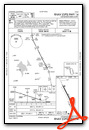
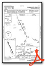
Instrument Approach Procedure (IAP) Charts
Nearby Airports with Instrument Procedures
| ID | Name | Heading / Distance | ||
|---|---|---|---|---|
 |
KMCE | Merced Yosemite Regional Airport | 052° | 21.6 |
|
F34 | Firebaugh Airport | 121° | 23.0 |
|
KMER | Castle Airport | 037° | 23.9 |
|
O15 | Turlock Municipal Airport | 018° | 26.5 |
|
KCVH | Hollister Municipal Airport | 248° | 27.9 |
|
KMOD | Modesto City-County-Harry Sham Field Airport | 353° | 33.9 |
|
E16 | San Martin Airport | 271° | 34.9 |
|
KMAE | Madera Municipal Airport | 096° | 36.7 |
|
O27 | Oakdale Airport | 004° | 41.6 |
|
KSNS | Salinas Municipal Airport | 236° | 42.9 |
|
KWVI | Watsonville Municipal Airport | 260° | 44.9 |
|
KTCY | Tracy Municipal Airport | 324° | 46.4 |
Airport Images

By: gilaomer


Comments
08/18/2012-flyin with video