Login
Register


MCE
Merced Yosemite Regional Airport
Official FAA Data Effective 2026-02-19 0901Z
Chart Supplement

VFR Chart of KMCE
Sectional Charts at SkyVector.com
IFR Chart of KMCE
Enroute Charts at SkyVector.com
Location Information for KMCE
Coordinates: N37°17.09' / W120°30.84'Located 02 miles SW of Merced, California on 766 acres of land. View all Airports in California.
Surveyed Elevation is 155 feet MSL.
Operations Data
|
|
Airport Communications
| ASOS: | 132.175 Tel. 209-381-0926 |
|---|---|
| NORCAL APPROACH: | 120.95 269.45 |
| NORCAL DEPARTURE: | 120.95 269.45 |
| CTAF: | 122.700 |
| UNICOM: | 122.700 |
| AWOS-3 at MER (5.6 N): | 209-725-0104 |
| ATIS at MER (6.3 NW): | 124.475 |
| AWOS-3 at LSN (21.6 SW): | 118.675 209-827-7084 |
Nearby Navigation Aids
|
| ||||||||||||||||||||||||||||||||||||


Runway 12/30
| Dimensions: | 5914 x 150 feet / 1803 x 46 meters | |
|---|---|---|
| Surface: | Asphalt / Porous Friction Course in Good Condition | |
| Weight Limits: | S-30, D-100, ST-155 | |
| Edge Lighting: | High Intensity | |
| Runway 12 | Runway 30 | |
| Coordinates: | N37°17.45' / W120°31.24' | N37°16.72' / W120°30.43' |
| Elevation: | 154.8 | 155.2 |
| Traffic Pattern: | Right | Left |
| Runway Heading: | 138° True | 318° True |
| Markings: | Precision Instrument in good condition. | Precision Instrument in good condition. |
| Glide Slope Indicator | V4L (3.00° Glide Path Angle) | P4L (3.00° Glide Path Angle) |
| Approach Lights: | MALSR 1,400 Foot Medium-intensity Approach Lighting System with runway alignment indicator lights. | |
| REIL: | Yes | |
| Obstacles: | 20 ft Pole 800 ft from runway, 225 ft left of center | 42 ft Power Line 1800 ft from runway, 650 ft left of center |
Services Available
| Fuel: | 100LL (blue), Jet-A |
|---|---|
| Transient Storage: | Tiedowns |
| Airframe Repair: | MAJOR |
| Engine Repair: | MAJOR |
| Bottled Oxygen: | NONE |
| Bulk Oxygen: | NONE |
| Other Services: | AIR FREIGHT SERVICES,CHARTER SERVICE,PILOT INSTRUCTION,AIRCRAFT RENTAL,AIRCRAFT SALES |
Ownership Information
| Ownership: | Publicly owned | |
|---|---|---|
| Owner: | CITY OF MERCED | |
| 678 WEST 18TH ST. | ||
| MERCED, CA 95340 | ||
| 209-564-0120 | 24 HOURS | |
| Manager: | RHETT WILLIAMS | EMAIL: WILLIAMSR@CITYOFMERCED.ORG |
| 20 MACREADY DR. | ||
| MERCED, CA 95341 | ||
| 209-385-6873 | OR 209-564-0120 | |
Other Remarks
- THIS AIRPORT HAS BEEN SURVEYED BY THE NATIONAL GEODETIC SURVEY.
- NOISE ABATEMENT PROCEDURES IN EFFECT, RECOMMEND ACFT REMAIN EAST/WEST OF CITY OF MERCED AT ALT ABOVE 1,500 FT MSL. DEPARTING TFC RWY 12 NO LEFT TURNS OVER CITY UNTIL REACHING 3,000 FT MSL.
- PPR 24 HRS FOR UNSKED ACFT OPNS WITH MORE THAN 30 PSGR SEATS CALL AMGR 209-564-0120.
- RY 30 PREFERRED WIND RUNWAY.
- BE ALERT FOR EXTENSIVE STUDENT TRAINING WITHIN 10 NMR OF AIRPORT. TWO-WAY RADIO COMMUNICATION RECOMMENDED.
- INCRD SEAGULL ACT ON RWY IN PUDDLES.
- FOR CD CTC NORCAL APCH AT 916-361-0516.
- ARFF INDEX B 24 HOURS PPR
- 0LL FOR FUEL AFT HRS CALL (209) 722-6300. SELF SERVICE 100LL AVBL 24/7.
- ACTVT MALSR RWY 30; REIL RWY 12; PAPI RWY 30; HIRL RWY 12/30 - CTAF; KEY 7 CLICKS HIGH, 5 CLICKS MED, 3 CLICKS LOW. VASI RWY 12 OPER CONSLY.
Weather Minimums
Instrument Approach Procedure (IAP) Charts


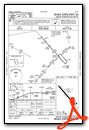
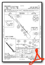
Nearby Airports with Instrument Procedures
| ID | Name | Heading / Distance | ||
|---|---|---|---|---|
 |
KMER | Castle Airport | 335° | 6.3 |
|
O15 | Turlock Municipal Airport | 323° | 14.8 |
|
KLSN | Los Banos Municipal Airport | 232° | 21.6 |
|
F34 | Firebaugh Airport | 174° | 25.6 |
|
KMAE | Madera Municipal Airport | 132° | 26.2 |
|
KMPI | Mariposa-Yosemite Airport | 059° | 26.4 |
|
KMOD | Modesto City-County-Harry Sham Field Airport | 314° | 29.3 |
|
O27 | Oakdale Airport | 334° | 31.4 |
|
E45 | Pine Mountain Lake Airport | 024° | 38.1 |
|
O22 | Columbia Airport | 006° | 44.9 |
|
KFCH | Fresno Chandler Exec Airport | 134° | 47.0 |
|
KFAT | Fresno Yosemite International Airport | 128° | 48.9 |
Airport Images
Do you have a recent image of this airport? Upload it here!


