Login
Register


O15
Turlock Municipal Airport
Official FAA Data Effective 2026-01-22 0901Z
Chart Supplement

VFR Chart of O15
Sectional Charts at SkyVector.com
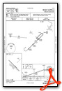
IFR Chart of O15
Enroute Charts at SkyVector.com
Location Information for O15
Coordinates: N37°29.04' / W120°41.84'Located 08 miles E of Turlock, California on 320 acres of land. View all Airports in California.
Surveyed Elevation is 160 feet MSL.
Operations Data
|
|
Airport Communications
| APPROACH: | 120.95 269.45 |
|---|---|
| DEPARTURE: | 120.95 269.45 |
| CTAF: | 122.800 |
| UNICOM: | 122.800 |
| ATIS at MER (8.7 SE): | 124.475 |
| AWOS-3 at MER (9.5 SE): | 209-725-0104 |
| ASOS at MCE (14.5 SE): | 132.175 209-381-0926 |
Nearby Navigation Aids
|
| ||||||||||||||||||||||||||||||||||||


Runway 12/30
| Dimensions: | 2985 x 50 feet / 910 x 15 meters | |
|---|---|---|
| Surface: | Asphalt in Poor Condition RWY IS CRACKED AND RAVELING. | |
| Weight Limits: | S-12 | |
| Edge Lighting: | Non-Standard NSTD LIRL; LGTS 20 FT FM EDGE OF RY. | |
| Runway 12 | Runway 30 | |
| Coordinates: | N37°29.22' / W120°42.05' | N37°28.86' / W120°41.63' |
| Elevation: | 160.8 | 160.6 |
| Traffic Pattern: | Left | Left |
| Markings: | Basic in poor condition. | Basic in fair condition. |
| Obstacles: | 30 ft Pole 800 ft from runway, 130 ft right of center | |
Services Available
| Fuel: | 100LL (blue) |
|---|---|
| Transient Storage: | Tiedowns |
| Airframe Repair: | NONE |
| Engine Repair: | NONE |
| Bottled Oxygen: | NONE |
| Bulk Oxygen: | NONE |
Ownership Information
| Ownership: | Publicly owned | |
|---|---|---|
| Owner: | CITY OF TURLOCK | ATTN: ERICK SCHULZE |
| 156 S. BROADWAY | ||
| TURLOCK, CA 95380 | ||
| 209-668-5542 | ||
| Manager: | CHRIS FISHER | |
| 144 S. BROADWAY | ||
| TURLOCK, CA 95380 | ||
| (209) 668-5599 | X 4604 | |
Other Remarks
- FOR CD CTC NORCAL APCH AT 916-361-0516.
- MRKGS ARE FADED AND NSTD.
- 0LL FUEL AVBL 24 HRS SELF SERVE CC.
- ACTVT LIRL RWY 12/30 - CTAF.
Weather Minimums

Instrument Approach Procedure (IAP) Charts
Nearby Airports with Instrument Procedures
| ID | Name | Heading / Distance | ||
|---|---|---|---|---|
 |
KMER | Castle Airport | 135° | 8.8 |
|
KMCE | Merced Yosemite Regional Airport | 143° | 14.8 |
|
KMOD | Modesto City-County-Harry Sham Field Airport | 304° | 14.9 |
|
O27 | Oakdale Airport | 343° | 17.0 |
|
KLSN | Los Banos Municipal Airport | 198° | 26.5 |
|
KMPI | Mariposa-Yosemite Airport | 086° | 31.4 |
|
E45 | Pine Mountain Lake Airport | 047° | 33.5 |
|
O22 | Columbia Airport | 022° | 35.4 |
|
KSCK | Stockton Metro Airport | 313° | 35.6 |
|
KTCY | Tracy Municipal Airport | 289° | 37.6 |
|
F34 | Firebaugh Airport | 163° | 39.0 |
|
KCPU | Calaveras County/Maury Rasmussen Field Airport | 003° | 39.7 |
Airport Images
Do you have a recent image of this airport? Upload it here!


Comments
FBO
FBO Operator is on the airport:
Skyview Aviation
skyviewaviation.com
209-830-7666
Aircraft rental and flight instructions available
Todd Smith