Login
Register


BKW
Raleigh County Memorial Airport
Official FAA Data Effective 2025-11-27 0901Z
Chart Supplement

VFR Chart of KBKW
Sectional Charts at SkyVector.com
IFR Chart of KBKW
Enroute Charts at SkyVector.com
Location Information for KBKW
Coordinates: N37°47.24' / W81°7.45'Located 03 miles E of Beckley, West Virginia on 1433 acres of land. View all Airports in West Virginia.
Surveyed Elevation is 2503 feet MSL.
Operations Data
|
|
Airport Communications
| ASOS: | 121.55 Tel. 304-362-0292 |
|---|---|
| CHARLESTON APPROACH: | 125.4 269.125 |
| CHARLESTON DEPARTURE: | 125.4 269.125 |
| CTAF: | 123.000 |
| UNICOM: | 123.000 |
| AWOS-3 at I16 (23.5 SW): | 120.625 304-732-7311 |
| ASOS at BLF (29.6 S): | 132.725 304-327-5766 |
| ATIS at LWB (34.6 E): | 121.4 |
Nearby Navigation Aids
|
| ||||||||||||||||||||||||||||||||||||||||||||||||||||||||||||


Runway 01/19
| Dimensions: | 6750 x 150 feet / 2057 x 46 meters | |
|---|---|---|
| Surface: | Asphalt / Grooved in Good Condition | |
| Weight Limits: | 38 /F/B/W/U, S-75, D-150, ST-200 | |
| Edge Lighting: | High Intensity | |
| Runway 01 | Runway 19 | |
| Coordinates: | N37°46.92' / W81°7.55' | N37°48.03' / W81°7.36' |
| Elevation: | 2495.3 | 2448.8 |
| Traffic Pattern: | Left | Left |
| Runway Heading: | 7° True | 187° True |
| Declared Distances: | TORA:6750 TODA:6750 ASDA:6750 LDA:6750 | TORA:6750 TODA:6750 ASDA:6750 LDA:6750 |
| Markings: | Non-Precision Instrument in good condition. | Precision Instrument in good condition. |
| Glide Slope Indicator | P4L (3.00° Glide Path Angle) | P4L (3.00° Glide Path Angle) |
| Approach Lights: | MALSR 1,400 Foot Medium-intensity Approach Lighting System with runway alignment indicator lights. | |
| REIL: | Yes | |
Runway 10/28
| Dimensions: | 5001 x 100 feet / 1524 x 30 meters | |
|---|---|---|
| Surface: | Asphalt in Good Condition | |
| Weight Limits: | 38 /F/B/W/U, S-45, D-60 | |
| Edge Lighting: | Medium Intensity | |
| Runway 10 | Runway 28 | |
| Coordinates: | N37°46.98' / W81°7.96' | N37°46.87' / W81°6.93' |
| Elevation: | 2485.7 | 2500.8 |
| Traffic Pattern: | Left | Left |
| Runway Heading: | 98° True | 278° True |
| Declared Distances: | TORA:5001 TODA:5001 ASDA:5001 LDA:5001 | TORA:5001 TODA:5001 ASDA:5001 LDA:5001 |
| Markings: | Non-Precision Instrument in good condition. | Non-Precision Instrument in good condition. |
| Glide Slope Indicator | V4R (3.00° Glide Path Angle) | V4L (3.75° Glide Path Angle) |
| REIL: | Yes | Yes |
Services Available
| Fuel: | 100LL (blue), Jet-A |
|---|---|
| Transient Storage: | Hangars,Tiedowns |
| Airframe Repair: | MAJOR |
| Engine Repair: | MAJOR |
| Bottled Oxygen: | NONE |
| Bulk Oxygen: | NONE |
| Other Services: | AIR AMBULANCE SERVICES,CARGO HANDLING SERVICES,CHARTER SERVICE,PILOT INSTRUCTION,AIRCRAFT RENTAL |
Ownership Information
| Ownership: | Publicly owned | |
|---|---|---|
| Owner: | RALEIGH COUNTY ARPT AUTH | |
| 176 AIRPORT CIRCLE RM 105 | ||
| BEAVER, WV 25813 | ||
| 304-255-0476 | ||
| Manager: | BOB RUNION | |
| 176 AIRPORT CIRCLE RM 105 | ||
| BEAVER, WV 25813 | ||
| 304-255-0476 | ||
Other Remarks
- THIS AIRPORT HAS BEEN SURVEYED BY THE NATIONAL GEODETIC SURVEY.
- DEER; BIRDS & WILD TURKEYS ON & INVOF ARPT.
- ALL SFCS WORK IN PROG, GRASS CUTTING APR THRU OCT.
- ACTVT MALSR RWY 19; REIL RWY 01, 10 & 28; VASI RWY 10 & 28; MIRL RWY 10/28; HIRL RWY 01/19; TWY LGTS - CTAF. PAPI RWY 01 & 19 SET AT MEDIUM, CTC UNICOM TO CHANGE INTST.
Weather Minimums

Instrument Approach Procedure (IAP) Charts


Nearby Airports with Instrument Procedures
| ID | Name | Heading / Distance | ||
|---|---|---|---|---|
 |
I16 | Kee Field Airport | 241° | 23.6 |
|
KSXL | Summersville Airport | 024° | 29.2 |
|
KBLF | Mercer County Airport | 187° | 29.7 |
|
KLWB | Greenbrier Valley Airport | 082° | 34.7 |
|
6L4 | Logan County Airport | 276° | 37.9 |
|
KCRW | West Virginia International Yeager Airport | 327° | 41.7 |
|
KPSK | New River Valley Airport | 151° | 44.4 |
|
KEBD | Southern West Virginia Regional Airport | 262° | 47.9 |
|
KBCB | Virginia Tech/Montgomery Exec Airport | 135° | 48.5 |
|
KJFZ | Tazewell County Airport | 216° | 54.0 |
|
KMKJ | Mountain Empire Airport | 191° | 54.6 |
|
48I | Braxton County Airport | 022° | 58.4 |
Airport Images
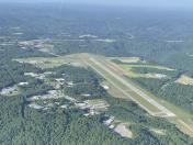
By: Big Orange Bird

By: Big Orange Bird


