Login
Register


M04
Covington Municipal Airport
Official FAA Data Effective 2026-02-19 0901Z
Chart Supplement

VFR Chart of M04
Sectional Charts at SkyVector.com
IFR Chart of M04
Enroute Charts at SkyVector.com
Location Information for M04
Coordinates: N35°35.00' / W89°35.23'Located 03 miles NE of Covington, Tennessee on 569 acres of land. View all Airports in Tennessee.
Surveyed Elevation is 280 feet MSL.
Operations Data
|
|
Airport Communications
| AWOS-3: | 118.575 Tel. 901-476-1705 |
|---|---|
| MEMPHIS APPROACH: | 120.075 125.8 338.3 |
| MEMPHIS DEPARTURE: | 124.15 385.45 |
| UNICOM: | 123.000 |
| CTAF: | 123.000 |
| AWOS-3 at NQA (18.9 SW): | 118.925 901-873-3630 |
| ASOS at HKA (24.4 NW): | 135.025 870-763-8206 |
| AWOS-3 at FYE (24.6 S): | 119.875 901-465-6367 |
Nearby Navigation Aids
|
| ||||||||||||||||||||||||||||||||||||||||||||||||||||||


Runway 01/19
CTN: WIP; MOWING & MAINT VEHICLES. | ||
| Dimensions: | 5003 x 100 feet / 1525 x 30 meters | |
|---|---|---|
| Surface: | Asphalt in Good Condition | |
| Weight Limits: | 2 /F/D/X/T | |
| Edge Lighting: | Medium Intensity | |
| Runway 01 | Runway 19 | |
| Coordinates: | N35°34.59' / W89°35.31' | N35°35.41' / W89°35.15' |
| Elevation: | 280.2 | 272.2 |
| Traffic Pattern: | Left | Left |
| Runway Heading: | 9° True | 189° True |
| Markings: | Non-Precision Instrument in good condition. | Non-Precision Instrument in good condition. |
| Glide Slope Indicator | P4L (3.00° Glide Path Angle) | P4L (3.00° Glide Path Angle) |
| REIL: | Yes | Yes |
| Obstacles: | 76 ft Tree 1763 ft from runway, 247 ft left of center | 42 ft Pole 1157 ft from runway, 472 ft left of center |
Services Available
| Fuel: | 100LL (blue), Jet A+ |
|---|---|
| Transient Storage: | Tiedowns |
| Airframe Repair: | NONE |
| Engine Repair: | NONE |
| Bottled Oxygen: | NONE |
| Bulk Oxygen: | NONE |
| Other Services: | CROP DUSTING SERVICES |
Ownership Information
| Ownership: | Publicly owned | |
|---|---|---|
| Owner: | CITY OF COVINGTON | |
| CITY HALL, 200 W. WASHINGTON AVE | ||
| COVINGTON, TN 38019 | ||
| 901-476-9613 | ||
| Manager: | WILLIAM LABERMEIER | |
| 169 AIRPORT PARKWAY DR | ||
| COVINGTON, TN 38019 | ||
| 901-476-1392 | ||
Other Remarks
- AGRICULTURAL OPS ON & INVOF ARPT MAY 1 - OCT 31.
- FOR CD CTC MEMPHIS APCH AT 901-842-8457.
- FUEL 24 HR SELF SVC WITH CREDIT CARD.
- ACTVT MIRL RWY 01/19 - CTAF. MIRL RWY 01/19 PRESET LOW INTST; INCR INTST - CTAF.
Weather Minimums

Instrument Approach Procedure (IAP) Charts
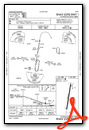
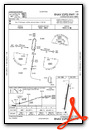
Nearby Airports with Instrument Procedures
| ID | Name | Heading / Distance | ||
|---|---|---|---|---|
 |
KNQA | Millington/Memphis Airport | 225° | 19.4 |
|
7M4 | Osceola Municipal Airport | 287° | 21.7 |
|
KFYE | Fayette County Airport | 157° | 24.4 |
|
KHKA | Blytheville Municipal Airport | 330° | 24.5 |
|
2M8 | Charles W Baker Airport | 222° | 24.9 |
|
KDYR | Dyersburg Regional Airport | 019° | 26.4 |
|
KBYH | Arkansas International Airport | 322° | 28.7 |
|
M01 | General Dewitt Spain Airport | 225° | 32.4 |
|
KMKL | Jackson Regional Airport | 088° | 32.9 |
|
KMXA | Manila Municipal Airport | 304° | 33.4 |
|
M12 | Steele Municipal Airport | 336° | 33.4 |
|
M08 | William L Whitehurst Field Airport | 129° | 34.6 |
Airport Images

By: Big Orange Bird


