Login
Register


M08
William L Whitehurst Field Airport
Official FAA Data Effective 2026-01-22 0901Z
Chart Supplement

VFR Chart of M08
Sectional Charts at SkyVector.com
IFR Chart of M08
Enroute Charts at SkyVector.com
Location Information for M08
Coordinates: N35°12.91' / W89°2.60'Located 04 miles SW of Bolivar, Tennessee on 194 acres of land. View all Airports in Tennessee.
Surveyed Elevation is 499 feet MSL.
Operations Data
|
|
Airport Communications
| AWOS-3: | 121.125 Tel. 731-658-6436 |
|---|---|
| UNICOM: | 123.000 |
| CTAF: | 123.000 |
| AWOS-3 at FYE (17.2 W): | 119.875 901-465-6367 |
| ASOS at MKL (23.5 N): | 119.325 731-424-0692 |
| AWOS-3 at SZY (26.7 E): | 118.425 731-645-8184 |
- APCH/DEP SVC PRVDD BY MEMPHIS ARTCC (ZME) ON FREQS 124.35/318.1 (MCKELLAR RCAG).
Nearby Navigation Aids
|
| ||||||||||||||||||||||||||||||||||||||||||||||||||||||


Runway 01/19
| Dimensions: | 5007 x 75 feet / 1526 x 23 meters | |
|---|---|---|
| Surface: | Asphalt in Fair Condition | |
| Weight Limits: | 11 /F/D/X/T, S-29, D-40 | |
| Edge Lighting: | Medium Intensity | |
| Runway 01 | Runway 19 | |
| Coordinates: | N35°12.50' / W89°2.66' | N35°13.32' / W89°2.54' |
| Elevation: | 499.0 | 493.0 |
| Traffic Pattern: | Left | Left |
| Runway Heading: | 6° True | 186° True |
| Markings: | Non-Precision Instrument in fair condition. | Non-Precision Instrument in fair condition. |
| Glide Slope Indicator | P2L (3.05° Glide Path Angle) | P2L (3.00° Glide Path Angle) |
| REIL: | Yes | Yes |
| Obstacles: | 62 ft Tree 1295 ft from runway, 298 ft left of center | 76 ft Tree 1537 ft from runway, 383 ft left of center |
Services Available
| Fuel: | 100LL (blue), Jet-A |
|---|---|
| Transient Storage: | Hangars,Tiedowns |
| Airframe Repair: | MAJOR |
| Engine Repair: | MAJOR |
| Bottled Oxygen: | NOT AVAILABLE |
| Bulk Oxygen: | NOT AVAILABLE |
| Other Services: | CROP DUSTING SERVICES,PILOT INSTRUCTION |
Ownership Information
| Ownership: | Publicly owned | |
|---|---|---|
| Owner: | HARDEMAN COUNTY | |
| HARDEMAN COUNTY COURTHOUSE, BOX 250 | ||
| BOLIVAR, TN 38009 | ||
| 731-658-3266 | ||
| Manager: | SHELBY W. ISHAM | |
| 800 AIRPORT RD | ||
| BOLIVAR, TN 38008 | ||
| 731-658-7556 | AFT HR 731-658-4547. | |
Other Remarks
- THIS AIRPORT HAS BEEN SURVEYED BY THE NATIONAL GEODETIC SURVEY.
- FUEL SVC AVBL H24 WITH CREDIT CARD.
- WILDLIFE INVOF ARPT.
- FOR CD CTC MEMPHIS ARTCC AT 901-368-8453/8449.
Weather Minimums

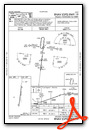
Instrument Approach Procedure (IAP) Charts

Nearby Airports with Instrument Procedures
| ID | Name | Heading / Distance | ||
|---|---|---|---|---|
 |
KFYE | Fayette County Airport | 268° | 17.3 |
|
KMKL | Jackson Regional Airport | 015° | 23.9 |
|
KSZY | Robert Sibley Airport | 091° | 26.8 |
|
KCRX | Roscoe Turner Airport | 129° | 28.2 |
|
25M | Ripley Airport | 177° | 29.5 |
|
M41 | Holly Springs-Marshall County Airport | 223° | 34.1 |
|
M04 | Covington Municipal Airport | 309° | 34.6 |
|
M53 | Humboldt Municipal Airport | 013° | 36.1 |
|
KOLV | Olive Branch/Taylor Field Airport | 249° | 39.3 |
|
M72 | New Albany/Union County Airport | 178° | 39.9 |
|
KSNH | Savannah-Hardin County Airport | 093° | 40.7 |
|
KNQA | Millington/Memphis Airport | 282° | 41.5 |
Airport Images
Do you have a recent image of this airport? Upload it here!


