Login
Register


BYH
Arkansas International Airport
Official FAA Data Effective 2025-11-27 0901Z
Chart Supplement

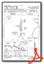
VFR Chart of KBYH
Sectional Charts at SkyVector.com
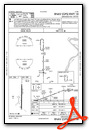
IFR Chart of KBYH
Enroute Charts at SkyVector.com
Location Information for KBYH
Coordinates: N35°57.86' / W89°56.64'Located 03 miles NW of Blytheville, Arkansas on 1100 acres of land. View all Airports in Arkansas.
Surveyed Elevation is 254 feet MSL.
Operations Data
|
|
Airport Communications
| UNICOM: | 122.700 |
|---|---|
| CTAF: | 122.700 |
| ASOS at HKA (5.7 E): | 135.025 870-763-8206 |
| AWOS-3PT at TKX (16.1 N): | 119.05 573-888-9640 |
| AWOS-3PT at DYR (26.2 E): | 135.625 731-287-0300 |
- APCH/DEP SVC PRVDD BY MEMPHIS ARTCC ON FREQS 134.65/316.15 (MCKELLAR RCAG).
Nearby Navigation Aids
|
| ||||||||||||||||||||||||||||||||||||||||||||||||||||||


Runway 18/36
| Dimensions: | 11602 x 150 feet / 3536 x 46 meters | |
|---|---|---|
| Surface: | Concrete in Good Condition | |
| Weight Limits: | S-155, D-235, ST-455 | |
| Edge Lighting: | High Intensity NSTD HIRL; LCTD 77 FT FM RWY EDGE & NSTD DSTC FM CNTRLN. DPT PRECEPTION PROBLEMS MAY EXIST DURG PDS OF DARKNESS. | |
| Runway 18 | Runway 36 | |
| Coordinates: | N35°58.82' / W89°56.64' | N35°56.90' / W89°56.64' |
| Elevation: | 250.3 | 252.0 |
| Traffic Pattern: | Left | Left |
| Runway Heading: | 180° True | 360° True |
| Markings: | Precision Instrument in fair condition. | Precision Instrument in fair condition. |
| Glide Slope Indicator | V4L (3.00° Glide Path Angle) RY 36 V4L OTS INDEFLY. | |
Services Available
| Fuel: | 100LL (blue), Jet-A |
|---|---|
| Transient Storage: | Tiedowns |
| Airframe Repair: | MAJOR |
| Engine Repair: | NOT AVAILABLE |
| Bottled Oxygen: | NOT AVAILABLE |
| Bulk Oxygen: | NOT AVAILABLE |
Ownership Information
| Ownership: | Publicly owned | |
|---|---|---|
| Owner: | GOSNELL REG AIRPORT AUTHORITY | |
| 4701 MEMORIAL DRIVE | ||
| BLYTHEVILLE, AR 72315-0166 | ||
| 870-532-2100 | ||
| Manager: | TODD RILEY | |
| 4701 MEMORIAL DRIVE | ||
| BLYTHEVILLE, AR 72315 | ||
| 870-532-5628 | ||
Other Remarks
- THIS AIRPORT HAS BEEN SURVEYED BY THE NATIONAL GEODETIC SURVEY.
- NO FEE CHRGD FOR SVC AFT HRS CTC/LV MSG - 870-532-5628.
- FOR CD CTC MEMPHIS ARTCC AT 901-368-8453/8449.
- TWY A BTN TWY B AND TWY D TKOF AND LDG AVBL TO MIL ACFT.
- 0LL FUEL AVBL 24 HRS SELF SERVE WITH CREDIT CARD (100 LL)
- DUSK-DAWN. ACTVT HIRL RY 18/36 - CTAF.
Weather Minimums

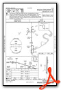
Instrument Approach Procedure (IAP) Charts
Nearby Airports with Instrument Procedures
| ID | Name | Heading / Distance | ||
|---|---|---|---|---|
 |
KHKA | Blytheville Municipal Airport | 104° | 5.7 |
|
M12 | Steele Municipal Airport | 027° | 8.9 |
|
KMXA | Manila Municipal Airport | 247° | 11.1 |
|
KTKX | Kennett Memorial Airport | 343° | 16.3 |
|
7M4 | Osceola Municipal Airport | 191° | 16.7 |
|
M05 | Caruthersville Memorial Airport | 046° | 17.9 |
|
KDYR | Dyersburg Regional Airport | 085° | 26.2 |
|
KPGR | Kirk Field Airport | 282° | 28.2 |
|
M04 | Covington Municipal Airport | 142° | 28.7 |
|
M85 | Gideon Memorial Airport | 003° | 28.8 |
|
KJBR | Jonesboro Municipal Airport | 257° | 35.2 |
|
KNQA | Millington/Memphis Airport | 174° | 36.6 |
Airport Images

By: arkansas.aeroplex


