Login
Register


NQA
Millington/Memphis Airport
Official FAA Data Effective 2026-01-22 0901Z
Chart Supplement

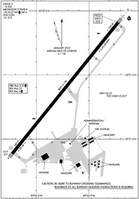
KNQA Airport Diagram
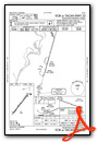
VFR Chart of KNQA
Sectional Charts at SkyVector.com
IFR Chart of KNQA
Enroute Charts at SkyVector.com
Location Information for KNQA
Coordinates: N35°21.40' / W89°52.23'Located 01 miles NE of Millington, Tennessee on 400 acres of land. View all Airports in Tennessee.
Surveyed Elevation is 322 feet MSL.
Operations Data
|
|
Airport Communications
| AWOS-3: | 118.925 Tel. 901-873-3630 |
|---|---|
| MILLINGTON TOWER: | 120.25 340.2 360.2 |
| MILLINGTON GROUND: | 121.375 |
| MEMPHIS APPROACH: | 119.1 ;176-355 120.075 ;356-175 120.925 ;356-175 125.8 ;356-175 126.7 ;176-355 291.6 ;176-355 338.3 ;356-175 |
| MEMPHIS DEPARTURE: | 124.15 ;356-175 124.65 ;176-355 284.7 ;176-355 385.45 ;356-175 |
| IC: | 119.1 ;176-355 125.8 ;356-175 291.6 ;176-355 338.3 ;356-175 |
| CLASS B: | 119.1 ;176-355 125.8 ;356-175 291.6 ;176-355 338.3 ;356-175 |
| CTAF: | 120.250 |
| UNICOM: | 122.950 |
| AWOS-3PT at 2M8 (5.6 SW): | 119.575 901-873-0903 |
| AWOS-3PT at M01 (13.0 SW): | 118.35 901-354-9296 |
| ASOS at MEM (18.9 S): | 127.75 901-842-8483 |
Nearby Navigation Aids
|
| ||||||||||||||||||||||||||||||||||||||||||||||||||||||||||||


Runway 04/22
| Dimensions: | 8001 x 150 feet / 2439 x 46 meters | |
|---|---|---|
| Surface: | Asphalt in Good Condition | |
| Edge Lighting: | High Intensity | |
| Runway 04 | Runway 22 | |
| Coordinates: | N35°20.89' / W89°52.73' | N35°21.91' / W89°51.72' |
| Elevation: | 277.4 | 322.3 |
| Traffic Pattern: | Right | |
| Runway Heading: | 39° True | 219° True |
| Markings: | Precision Instrument in good condition. | Precision Instrument in good condition. |
| Glide Slope Indicator | P4L (3.00° Glide Path Angle) | P4L (3.00° Glide Path Angle) |
| Approach Lights: | MALSR 1,400 Foot Medium-intensity Approach Lighting System with runway alignment indicator lights. | |
| REIL: | Yes | Yes |
Services Available
| Fuel: | 100LL (blue), Jet A+ |
|---|---|
| Transient Storage: | Hangars,Tiedowns |
| Airframe Repair: | MAJOR |
| Engine Repair: | MAJOR |
| Bottled Oxygen: | LOW |
| Bulk Oxygen: | NOT AVAILABLE |
| Other Services: | AVIONICS |
Ownership Information
| Ownership: | Publicly owned | |
|---|---|---|
| Owner: | MILLINGTON ARPT AUTH | |
| 8182 HORNET AVE | ||
| MILLINGTON, TN 38053 | ||
| 901-872-7495 | ||
| Manager: | MR. MIKE GILL | |
| 8182 HORNET AVE | ||
| MILLINGTON, TN 38053 | ||
| 901-872-7495 | ||
Other Remarks
- CAT C AFLD.
- TWY B CLSD TO ACR.
- FOR CD WHEN ATCT IS CLSD CTC MEM APCH AT 901-842-8457.
- 0LL JASU AVBL.
- ACTVT MALSR RWY 22; REIL RWY 04; HIRL RWY 04/22 - CTAF. HIRL RWY 04/22 PRESET LOW INTST; INCR INTST - CTAF. PAPI RWY 04 & 22 ON CONSLY.
Weather Minimums


Instrument Approach Procedure (IAP) Charts
Nearby Airports with Instrument Procedures
| ID | Name | Heading / Distance | ||
|---|---|---|---|---|
 |
2M8 | Charles W Baker Airport | 213° | 5.6 |
|
M01 | General Dewitt Spain Airport | 224° | 13.0 |
|
M04 | Covington Municipal Airport | 045° | 19.4 |
|
KMEM | Frederick W Smith International Airport | 195° | 19.5 |
|
7M4 | Osceola Municipal Airport | 341° | 21.2 |
|
KAWM | West Memphis Municipal Airport | 233° | 22.3 |
|
KOLV | Olive Branch/Taylor Field Airport | 169° | 23.0 |
|
KFYE | Fayette County Airport | 110° | 25.0 |
|
KHKA | Blytheville Municipal Airport | 003° | 35.0 |
|
KMXA | Manila Municipal Airport | 336° | 35.1 |
|
KBYH | Arkansas International Airport | 354° | 36.6 |
|
M41 | Holly Springs-Marshall County Airport | 152° | 37.3 |
Airport Images
Do you have a recent image of this airport? Upload it here!


