Login
Register


M32
Lake Village Municipal Airport
Official FAA Data Effective 2025-12-25 0901Z
Chart Supplement

VFR Chart of M32
Sectional Charts at SkyVector.com
IFR Chart of M32
Enroute Charts at SkyVector.com
Location Information for M32
Coordinates: N33°20.79' / W91°18.93'Located 02 miles W of Lake Village, Arkansas on 50 acres of land. View all Airports in Arkansas.
Surveyed Elevation is 126 feet MSL.
Operations Data
|
|
Airport Communications
| CTAF: | 122.900 |
|---|---|
| ASOS at GLH (19.0 NE): | 125.525 662-332-0863 |
| ASOS at LLQ (28.0 NW): | 133.325 870-367-1019 |
| AWOS-3PT at RNV (37.4 NE): | 124.175 662-843-3021 |
- APCH/DEP SVC PRVDD BY MEMPHIS ARTCC ON FREQS 135.875/269.35 (GREENVILLE RCAG & PINE BLUFF RCAG).
Nearby Navigation Aids
|
| ||||||||||||||||||||||||||||||||||||||||||||||||||||||||||||


Runway 01/19
| Dimensions: | 4400 x 75 feet / 1341 x 23 meters | |
|---|---|---|
| Surface: | Asphalt in Good Condition | |
| Weight Limits: | S-18 | |
| Edge Lighting: | Medium Intensity | |
| Runway 01 | Runway 19 | |
| Coordinates: | N33°20.44' / W91°19.04' | N33°21.14' / W91°18.83' |
| Elevation: | 125.9 | 124.5 |
| Traffic Pattern: | Left | Left |
| Runway Heading: | 14° True | 194° True |
| Markings: | Non-Precision Instrument in good condition. | Non-Precision Instrument in good condition. |
| Glide Slope Indicator | P2L (3.00° Glide Path Angle) | P2L (3.00° Glide Path Angle) |
| Obstacles: | 24 ft Trees 1050 ft from runway, 200 ft left of center | 25 ft Trees 880 ft from runway, 255 ft right of center |
Services Available
| Fuel: | 100LL (blue), Jet-A |
|---|---|
| Transient Storage: | Tiedowns |
| Airframe Repair: | NONE |
| Engine Repair: | NONE |
| Bottled Oxygen: | NONE |
| Bulk Oxygen: | NONE |
| Other Services: | CROP DUSTING SERVICES,PILOT INSTRUCTION |
Ownership Information
| Ownership: | Publicly owned | |
|---|---|---|
| Owner: | CITY OF LAKE VILLAGE | |
| PO BOX 725 | ||
| LAKE VILLAGE, AR 71653 | ||
| 870-265-2228 | ||
| Manager: | REAGAN CLARK | |
| 925 HIGHWAY 65 & 82 | ||
| LAKE VILLAGE, AR 71653 | ||
| 870-265-2723 | ||
Other Remarks
- NUMEROUS AGRICULTURAL OPNS FEB-OCT BELOW 500 FT.
- FOR CD CTC MEMPHIS ARTCC AT 901-368-8453/8449.
- ACTVT MIRL RWY 01/19, PAPI RWY 01 & 19 - CTAF.
Weather Minimums
Instrument Approach Procedure (IAP) Charts
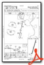
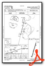
Nearby Airports with Instrument Procedures
| ID | Name | Heading / Distance | ||
|---|---|---|---|---|
 |
7M1 | Mc Gehee Municipal Airport | 351° | 16.6 |
|
KGLH | Greenville Mid-Delta Airport | 063° | 18.6 |
|
KLLQ | Monticello Municipal/Ellis Field Airport | 308° | 28.0 |
|
KCRT | Z M Jack Stell Field Airport | 250° | 30.1 |
|
KIDL | Indianola Municipal Airport | 075° | 33.0 |
|
0M0 | Billy Free Municipal Airport | 341° | 34.0 |
|
KRNV | Cleveland Municipal Airport | 048° | 37.4 |
|
3M9 | Warren Municipal/John B Frazer Jr Field Airport | 288° | 40.7 |
|
KBQP | Morehouse Memorial Airport | 219° | 45.4 |
|
M37 | Ruleville-Drew Airport | 056° | 47.3 |
|
87I | Yazoo County Airport | 122° | 51.1 |
|
5M1 | Dewitt Municipal/Whitcomb Field Airport | 000° | 54.8 |
Airport Images
Do you have a recent image of this airport? Upload it here!


