Login
Register


MBO
Bruce Campbell Field Airport
Official FAA Data Effective 2026-01-22 0901Z
Chart Supplement

VFR Chart of KMBO
Sectional Charts at SkyVector.com
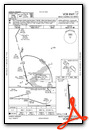
IFR Chart of KMBO
Enroute Charts at SkyVector.com
Location Information for KMBO
Coordinates: N32°26.32' / W90°6.19'Located 02 miles SE of Madison, Mississippi on 260 acres of land. View all Airports in Mississippi.
Surveyed Elevation is 325 feet MSL.
Operations Data
|
|
Airport Communications
| AWOS-3PT: | 119.125 Tel. 601-605-8137 |
|---|---|
| JACKSON APPROACH: | 123.9 ;333-152 125.25 ;153-332 317.7 ;333-152 319.2 ;153-332 |
| JACKSON DEPARTURE: | 123.9 ;333-152 125.25 ;153-332 317.7 ;333-152 319.2 ;153-332 |
| IC: | 123.9 ;333-152 317.7 ;333-152 |
| CLEARANCE DELIVERY: | 125.9 |
| CTAF: | 122.800 |
| UNICOM: | 122.800 |
| ATIS at JAN (7.8 S): | 121.05 |
| ASOS at JAN (7.8 S): | 121.05 601-769-1216 |
| ASOS at HKS (8.7 SW): | 120.625 601-354-4037 |
- APCH/DEP SVC PRVDD BY MEMPHIS ARTCC ON FREQS 132.5/259.1 (JACKSON RCAG) WHEN JACKSON APCH CTL CLSD.
Nearby Navigation Aids
|
| ||||||||||||||||||||||||||||||||||||||||||||||||||||||||||||


Runway 17/35
| Dimensions: | 4444 x 75 feet / 1355 x 23 meters | |
|---|---|---|
| Surface: | Asphalt in Good Condition | |
| Weight Limits: | S-25 | |
| Edge Lighting: | Medium Intensity | |
| Runway 17 | Runway 35 | |
| Coordinates: | N32°26.69' / W90°6.22' | N32°25.95' / W90°6.15' |
| Elevation: | 325.1 | 314.0 |
| Traffic Pattern: | Left | Left |
| Runway Heading: | 175° True | 355° True |
| Markings: | Non-Precision Instrument in good condition. | Non-Precision Instrument in good condition. |
| Glide Slope Indicator | P2L (3.00° Glide Path Angle) | P2L (4.00° Glide Path Angle) PAPI OTS INDEF. |
| Obstacles: | 66 ft Trees 1540 ft from runway, 200 ft right of center | 71 ft Trees 1650 ft from runway, 200 ft left of center |
Services Available
| Fuel: | 100LL (blue), Jet A-1+ |
|---|---|
| Transient Storage: | Hangars,Tiedowns |
| Airframe Repair: | MINOR |
| Engine Repair: | MINOR |
| Bottled Oxygen: | NOT AVAILABLE |
| Bulk Oxygen: | NONE |
| Other Services: | PILOT INSTRUCTION,AIRCRAFT RENTAL |
Ownership Information
| Ownership: | Publicly owned | |
|---|---|---|
| Owner: | CITY OF MADISON | |
| TOWN HALL (PO BOX 40) | ||
| MADISON, MS 39130 | ||
| 601-856-7116 | ||
| Manager: | GUY BOWERING | |
| PO BOX 40 | ||
| MADISON, MS 39130 | ||
| 601-853-1960 | ||
Other Remarks
- WHEN APCH CLSD, FOR CD CTC MEMPHIS ARTCC AT 901-368-8453/8449.
- ACTVT PAPI RWY 17 & 35; MIRL RWY 17/35 - CTAF.
Weather Minimums
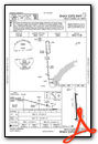
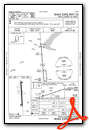
Instrument Approach Procedure (IAP) Charts
Nearby Airports with Instrument Procedures
| ID | Name | Heading / Distance | ||
|---|---|---|---|---|
 |
KJAN | Jackson-Medgar Wiley Evers International Airport | 169° | 7.8 |
|
KHKS | Hawkins Field Airport | 224° | 8.7 |
|
KJVW | John Bell Williams Airport | 242° | 17.6 |
|
87I | Yazoo County Airport | 325° | 32.3 |
|
M11 | Copiah County Airport | 202° | 34.8 |
|
17M | Magee Municipal Airport | 155° | 37.8 |
|
19M | C A Moore Airport | 005° | 41.3 |
|
KVKS | Vicksburg Municipal Airport | 254° | 43.6 |
|
KTVR | Vicksburg Tallulah Regional Airport | 263° | 47.3 |
|
KOSX | Kosciusko-Attala County Airport | 035° | 48.3 |
|
M43 | Prentiss-Jefferson Davis County Airport | 168° | 51.5 |
|
1R7 | Brookhaven-Lincoln County Airport | 197° | 52.3 |
Airport Images

By: Samkjurgens


