Login
Register


JVW
John Bell Williams Airport
Official FAA Data Effective 2025-11-27 0901Z
Chart Supplement

VFR Chart of KJVW
Sectional Charts at SkyVector.com
IFR Chart of KJVW
Enroute Charts at SkyVector.com
Location Information for KJVW
Coordinates: N32°18.27' / W90°24.63'Located 03 miles NE of Raymond, Mississippi on 284 acres of land. View all Airports in Mississippi.
Surveyed Elevation is 247 feet MSL.
Operations Data
|
|
Airport Communications
| AWOS-3PT: | 118.675 Tel. 601-857-3887 |
|---|---|
| JACKSON APPROACH: | 125.25 ;153-332 319.2 ;153-332 |
| JACKSON DEPARTURE: | 125.25 ;153-332 319.2 ;153-332 |
| UNICOM: | 123.000 |
| CTAF: | 123.000 |
| ASOS at HKS (9.7 E): | 120.625 601-354-4037 |
| ATIS at JAN (17.0 E): | 121.05 |
| ASOS at JAN (17.0 E): | 121.05 601-769-1216 |
- APCH/DEP SVC PRVDD BY MEMPHIS ARTCC ON FREQS 132.5/259.1 (JACKSON RCAG) WHEN JACKSON APCH CTL CLSD.
- IFR CLEARANCES ISSUED BY JACKSON APCH VIA RECORDED TELEPHONE LINE CALL 601-965-4625.
Nearby Navigation Aids
|
| ||||||||||||||||||||||||||||||||||||||||||||||||||||||||||||


Runway 12/30
| Dimensions: | 5499 x 100 feet / 1676 x 30 meters | |
|---|---|---|
| Surface: | Asphalt / Rubberized Friction Seal Coated in Good Condition | |
| Weight Limits: | S-60, D-75 | |
| Edge Lighting: | Medium Intensity | |
| Runway 12 | Runway 30 | |
| Coordinates: | N32°18.52' / W90°25.08' | N32°18.02' / W90°24.19' |
| Elevation: | 240.1 | 246.9 |
| Traffic Pattern: | Left | Left |
| Runway Heading: | 124° True | 304° True |
| Markings: | Precision Instrument in fair condition. | Non-Precision Instrument in fair condition. |
| Glide Slope Indicator | P4L (3.00° Glide Path Angle) | P2L (4.00° Glide Path Angle) |
| REIL: | Yes | Yes |
| Obstacles: | 80 ft Trees 1250 ft from runway | |
Services Available
| Fuel: | 100LL (blue), Jet-A |
|---|---|
| Transient Storage: | Hangars,Tiedowns PILOTS MUST PRVD THEIR OWN TIEDOWN ROPES. |
| Airframe Repair: | MAJOR |
| Engine Repair: | MAJOR |
| Bottled Oxygen: | NONE |
| Bulk Oxygen: | NONE |
| Other Services: | PILOT INSTRUCTION,AIRCRAFT RENTAL |
Ownership Information
| Ownership: | Publicly owned | |
|---|---|---|
| Owner: | HINDS COMMUNITY COLLEGE | |
| PO BOX 1265 HCC | ||
| RAYMOND, MS 39154 | ||
| 601-857-3367 | ||
| Manager: | HIRAM HANEY | |
| HINDS COMMUNITY COLLEGE, P.O. BOX 1100 | ||
| RAYMOND, MS 39154 | ||
| 601-857-3884 | ||
Other Remarks
- WHEN APCH CLSD, FOR CD CTC MEMPHIS ARTCC AT 901-368-8453/8449.
- PAINT FAC.
- COURTESY CAR AVBL.
- 0LL FUEL AVBL 24 HRS WITH CREDIT CARD.
- ACTVT REIL RWY 12 & 30; MIRL RWY 12/30 - CTAF. PAPI RWY 12 & 30 OPR CONSLY.
Weather Minimums


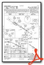
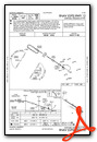
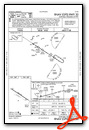
Instrument Approach Procedure (IAP) Charts
Nearby Airports with Instrument Procedures
| ID | Name | Heading / Distance | ||
|---|---|---|---|---|
 |
KHKS | Hawkins Field Airport | 079° | 9.7 |
|
KJAN | Jackson-Medgar Wiley Evers International Airport | 088° | 17.0 |
|
KMBO | Bruce Campbell Field Airport | 062° | 17.6 |
|
M11 | Copiah County Airport | 174° | 24.2 |
|
KVKS | Vicksburg Municipal Airport | 261° | 26.6 |
|
KTVR | Vicksburg Tallulah Regional Airport | 275° | 31.5 |
|
87I | Yazoo County Airport | 355° | 34.8 |
|
17M | Magee Municipal Airport | 130° | 40.8 |
|
1R7 | Brookhaven-Lincoln County Airport | 179° | 41.8 |
|
M43 | Prentiss-Jefferson Davis County Airport | 148° | 49.6 |
|
19M | C A Moore Airport | 021° | 52.9 |
|
KHEZ | Hardy-Anders Field/Natchez-Adams County Airport | 227° | 61.3 |
Airport Images
Do you have a recent image of this airport? Upload it here!


