Login
Register


MCB
Mc Comb/Pike County/John E Lewis Field Airport
Official FAA Data Effective 2026-02-19 0901Z
Chart Supplement

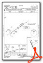
VFR Chart of KMCB
Sectional Charts at SkyVector.com
IFR Chart of KMCB
Enroute Charts at SkyVector.com
Location Information for KMCB
Coordinates: N31°10.71' / W90°28.31'Located 04 miles S of Mc Comb, Mississippi on 430 acres of land. View all Airports in Mississippi.
Surveyed Elevation is 413 feet MSL.
Operations Data
|
|
Airport Communications
| ASOS: | 119.025 Tel. 601-249-3223 |
|---|---|
| UNICOM: | 123.050 |
| CTAF: | 123.050 |
| AWOS-3T at 1R7 (25.9 N): | 118.125 601-833-3209 |
| AWOS-3PT at 0R0 (34.4 E): | 120.675 601-736-4983 |
| AWOS-3PT at BXA (38.8 SE): | 118.025 985-732-6224 |
- APCH/DEP SVC PRVDD BY HOUSTON ARTCC (ZHU) ON FREQS 126.8/327.8 (MC COMB RCAG).
Nearby Navigation Aids
|
| ||||||||||||||||||||||||||||||||||||||||||||||||||||||||||||


Runway 16/34
| Dimensions: | 5000 x 100 feet / 1524 x 30 meters | |
|---|---|---|
| Surface: | Asphalt / Grooved in Fair Condition | |
| Weight Limits: | 40 /F/A/Y/T, S-25, D-172, ST-308 | |
| Edge Lighting: | Medium Intensity | |
| Runway 16 | Runway 34 | |
| Coordinates: | N31°11.08' / W90°28.51' | N31°10.33' / W90°28.11' |
| Elevation: | 413.1 | 389.0 |
| Traffic Pattern: | Left | Left |
| Runway Heading: | 156° True | 336° True |
| Markings: | Precision Instrument in poor condition. | Non-Precision Instrument in poor condition. |
| Glide Slope Indicator | P4L (3.00° Glide Path Angle) | P2L (3.00° Glide Path Angle) |
| Approach Lights: | MALSF 1,400 Foot Medium-intensity Approach Lighting System with sequenced flashers. | |
Services Available
| Fuel: | 100LL (blue), Jet A-1+ |
|---|---|
| Transient Storage: | Hangars,Tiedowns PILOTS MUST PRVD THEIR OWN TIEDOWN ROPES. |
| Airframe Repair: | MINOR |
| Engine Repair: | MINOR |
| Bottled Oxygen: | NONE |
| Bulk Oxygen: | NONE |
Ownership Information
| Ownership: | Publicly owned | |
|---|---|---|
| Owner: | CITY OF MC COMB & PIKE COUNTY | |
| 2051 JOHN E. LEWIS DR | ||
| MCCOMB, MS 39648 | ||
| 601-684-8950 | ||
| Manager: | RICK SIMPSON | |
| 2051 JOHN E. LEWIS DR | ||
| MCCOMB, MS 39648 | ||
| 601-684-8950 | ||
Other Remarks
- THIS AIRPORT HAS BEEN SURVEYED BY THE NATIONAL GEODETIC SURVEY.
- COURTESY CAR AVBL.
- FOR CD IF UNA TO CTC ON FSS FREQ, CTC HOUSTON ARTCC AT 281-230-5622.
- MARKINGS FADED.
- MARKINGS FADED.
- 0LL FOR ATTENDANT & FUEL AFT HRS CALL 601-684-8950.
- ACTVT MALSF RWY 16 - CTAF. MIRL RWY 16/34 PRESET LOW INTST DUSK-0000, AFT 0000 INCR INTST - CTAF.
Weather Minimums


Instrument Approach Procedure (IAP) Charts


Nearby Airports with Instrument Procedures
| ID | Name | Heading / Distance | ||
|---|---|---|---|---|
 |
1R7 | Brookhaven-Lincoln County Airport | 007° | 25.8 |
|
0R0 | Columbia/Marion County Airport | 077° | 34.7 |
|
KBXA | George R Carr Memorial Air Field Airport | 124° | 38.2 |
|
M43 | Prentiss-Jefferson Davis County Airport | 049° | 38.3 |
|
KHDC | Hammond Northshore Regional Airport | 175° | 39.4 |
|
M11 | Copiah County Airport | 007° | 43.7 |
|
KHEZ | Hardy-Anders Field/Natchez-Adams County Airport | 301° | 49.8 |
|
KBTR | Baton Rouge Metro, Ryan Field Airport | 222° | 52.1 |
|
17M | Magee Municipal Airport | 039° | 53.5 |
|
M13 | Poplarville/Pearl River County Airport | 114° | 55.1 |
|
0R4 | Concordia Parish Airport | 293° | 57.9 |
|
KHZR | False River Regional Airport | 242° | 58.8 |
Airport Images
Do you have a recent image of this airport? Upload it here!


