Login
Register


HEZ
Hardy-Anders Field/Natchez-Adams County Airport
Official FAA Data Effective 2026-01-22 0901Z
Chart Supplement

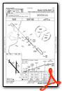
VFR Chart of KHEZ
Sectional Charts at SkyVector.com
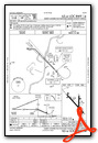
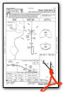
IFR Chart of KHEZ
Enroute Charts at SkyVector.com
Location Information for KHEZ
Coordinates: N31°36.82' / W91°17.84'Located 06 miles NE of Natchez, Mississippi on 900 acres of land. View all Airports in Mississippi.
Surveyed Elevation is 272 feet MSL.
Operations Data
|
|
Airport Communications
| AWOS-3PT: | 124.675 Tel. 601-446-8022 |
|---|---|
| CTAF: | 122.800 |
| UNICOM: | 122.800 |
| AWOS-3 at 0R4 (11.3 W): | 118.2 318-336-8028 |
| AWOS-3 at VKS (41.9 NE): | 118.85 601-801-5376 |
| AWOS-3T at 1R7 (45.5 E): | 118.125 601-833-3209 |
- APCH/DEP SVC PRVDD BY HOUSTON ARTCC (ZHU) ON FREQS 120.975/299.6 (NATCHEZ RCAG).
Nearby Navigation Aids
|
| ||||||||||||||||||||||||||||||||||||||||||||||||||||||||||||


Runway 14/32
| Dimensions: | 6500 x 150 feet / 1981 x 46 meters | |
|---|---|---|
| Surface: | Asphalt / Grooved in Excellent Condition | |
| Weight Limits: | S-50, D-78, ST-172
PCR VALUE: 45/F/B/X/T
| |
| Edge Lighting: | High Intensity | |
| Runway 14 | Runway 32 | |
| Coordinates: | N31°37.23' / W91°18.35' | N31°36.46' / W91°17.49' |
| Elevation: | 261.5 | 269.3 |
| Traffic Pattern: | Left | Left |
| Runway Heading: | 136° True | 316° True |
| Markings: | Precision Instrument in good condition. | Non-Precision Instrument in good condition. |
| Glide Slope Indicator | P4R (3.00° Glide Path Angle) | P4L (3.00° Glide Path Angle) |
| Approach Lights: | MALSR 1,400 Foot Medium-intensity Approach Lighting System with runway alignment indicator lights. | |
| Obstacles: | 78 ft Trees 2400 ft from runway | |
Runway 18/36
RWY 18/36 NOT AVBL FOR PART 121/PART 380 OPS WITH SKED PAX CARRYING OPS MORE THAN 9 PAX SEATS AND NON-SKED PAX CARRYING OPS MORE THAN 30 PAX SEATS. | ||
| Dimensions: | 5000 x 150 feet / 1524 x 46 meters | |
|---|---|---|
| Surface: | Asphalt in Poor Condition WIDESPREAD CRACKING & UNEVEN PAVEMENT. | |
| Weight Limits: | 35 /F/B/Y/T, S-83, D-113, ST-65 | |
| Edge Lighting: | Medium Intensity | |
| Runway 18 | Runway 36 | |
| Coordinates: | N31°37.20' / W91°17.73' | N31°36.37' / W91°17.74' |
| Elevation: | 269.4 | 260.2 |
| Traffic Pattern: | Left | Left |
| Runway Heading: | 181° True | 1° True |
| Markings: | Non-Precision Instrument in poor condition. | Non-Precision Instrument in poor condition. |
| Glide Slope Indicator | V4L (3.00° Glide Path Angle) | |
| Obstacles: | 63 ft Trees 1400 ft from runway, 300 ft right of center | |
Services Available
| Fuel: | 100LL (blue), Jet-A |
|---|---|
| Transient Storage: | Hangars,Tiedowns |
| Airframe Repair: | MINOR |
| Engine Repair: | MINOR |
| Bottled Oxygen: | NONE |
| Bulk Oxygen: | NONE |
| Other Services: | PILOT INSTRUCTION |
Ownership Information
| Ownership: | Publicly owned | |
|---|---|---|
| Owner: | ADAMS COUNTY | |
| BOX 1008 | ||
| NATCHEZ, MS 39121 | ||
| 601-442-2431 | ||
| Manager: | RICHARD NELSON | |
| 434 AIRPORT RD | ||
| NATCHEZ, MS 39120 | ||
| 601-442-5171 | ||
Other Remarks
- GND PWR UNIT AVBL ON FLD.
- DEER ON & INVOF RWYS.
- TWY A & C1 NOT AVBL FOR ACR USE.
- MARKINGS FADED.
- MARKINGS FADED.
- ACTVT MALSR RWY 14; PAPI RWY 14 & 32; VASI RWY 18; MIRL RWY 18/36 - CTAF.
Weather Minimums
Instrument Approach Procedure (IAP) Charts


Nearby Airports with Instrument Procedures
| ID | Name | Heading / Distance | ||
|---|---|---|---|---|
 |
0R4 | Concordia Parish Airport | 253° | 11.2 |
|
KVKS | Vicksburg Municipal Airport | 026° | 41.9 |
|
1R7 | Brookhaven-Lincoln County Airport | 090° | 45.5 |
|
KTVR | Vicksburg Tallulah Regional Airport | 017° | 46.3 |
|
KMCB | Mc Comb/Pike County/John E Lewis Field Airport | 121° | 49.8 |
|
KMKV | Marksville Municipal Airport | 232° | 50.4 |
|
M11 | Copiah County Airport | 069° | 50.6 |
|
KESF | Esler Regional Airport | 255° | 52.9 |
|
KHZR | False River Regional Airport | 189° | 54.4 |
|
M79 | John H Hooks Jr Memorial Airport | 335° | 57.5 |
|
KJVW | John Bell Williams Airport | 047° | 61.3 |
|
2R6 | Bunkie Municipal Airport | 231° | 62.2 |
Airport Images
Do you have a recent image of this airport? Upload it here!


Comments
Crew Car Fees
This FBO has outrageous fees ($50) to use crew car. The fees are lowered but still outrageous if purchasing a minimum of 35 gallons of fuel. They do have free water. They should consider fees only if vehicle is not returned within a reasonable timeframe.