Login
Register


HZR
False River Regional Airport
Official FAA Data Effective 2026-01-22 0901Z
Chart Supplement

VFR Chart of KHZR
Sectional Charts at SkyVector.com
IFR Chart of KHZR
Enroute Charts at SkyVector.com
Location Information for KHZR
Coordinates: N30°43.10' / W91°28.72'Located 02 miles NW of New Roads, Louisiana on 152 acres of land. View all Airports in Louisiana.
Surveyed Elevation is 39 feet MSL.
TPA: 260 FT AGL ULTRA-LGT, 460 FT AGL HEL, 960 FT AGL FIXED WING WI 3 NM OF ARPT.
Operations Data
|
|
Airport Communications
| AWOS-3PT: | 121.250 Tel. 225-638-3107 |
|---|---|
| BATON ROUGE APPROACH: | 120.3 278.3 |
| BATON ROUGE DEPARTURE: | 120.3 278.3 |
| UNICOM: | 122.800 |
| CTAF: | 122.800 |
| ASOS at BTR (20.3 SE): | 225-370-8455 |
| ATIS at BTR (20.3 SE): | 125.2 |
| AWOS-3PT at OPL (33.5 W): | 118.775 337-948-8560 |
- APCH/DEP SVC PRVDD BY HOUSTON ARTCC (ZHU) ON FREQS 126.35/338.25 (LAFAYETTE RCAG) WHEN BATON ROUGE (BTR) APCH CTL CLSD.
Nearby Navigation Aids
|
| ||||||||||||||||||||||||||||||||||||||||||||||||||||||||||||


Runway 18/36
| Dimensions: | 5003 x 75 feet / 1525 x 23 meters | |
|---|---|---|
| Surface: | Asphalt in Good Condition RSCD NOT RPRTED 2100-1300 M-F AND 0500-0459 ON WKENDS, HOLS. | |
| Weight Limits: | S-30 | |
| Edge Lighting: | Medium Intensity | |
| Runway 18 | Runway 36 | |
| Coordinates: | N30°43.51' / W91°28.68' | N30°42.69' / W91°28.76' |
| Elevation: | 38.9 | 32.4 |
| Traffic Pattern: | Left | Left |
| Runway Heading: | 184° True | 4° True |
| Markings: | Non-Precision Instrument in good condition. | Non-Precision Instrument in good condition. |
| Glide Slope Indicator | P2L (3.00° Glide Path Angle) | P2L (3.00° Glide Path Angle) |
| Approach Lights: | ODALS Omnidirectional Approach Lighting System | |
| REIL: | Yes | |
Services Available
| Fuel: | 100LL (blue) |
|---|---|
| Transient Storage: | Tiedowns |
| Airframe Repair: | NONE |
| Engine Repair: | NONE |
| Bottled Oxygen: | NONE |
| Bulk Oxygen: | NONE |
| Other Services: | CROP DUSTING SERVICES,PILOT INSTRUCTION |
Ownership Information
| Ownership: | Publicly owned | |
|---|---|---|
| Owner: | CITY OFNEW RDS-POINTE COUPEE PARISH | |
| PO BOX 97 | ||
| NEW ROADS, LA 70760 | ||
| 225-638-3192 | ||
| Manager: | JEAN-PIERRE DUROUSSEAU | |
| PO BOX 97 | ||
| NEW ROADS, LA 70760 | ||
| 504-273-9018 | ||
Other Remarks
- DUAL LIGHTING SYSTEM OPERATIONS IN EFFECT DUE TO TESTING OF LED MIRL & TWY LGTS INDEFLY.
- FOR CD CTC HOUSTON ARTCC AT 281-230-5622.
- PUB PRKG PLS CTC AMGR AT 504-273-9018
- 0LL FUEL AVBL 24 HRS SELF SERVICE WITH CREDIT CARD.
- ACTVT REIL RWY 18 - 122.8. MIRL RWY 18/36; ODALS RWY 36 PRESET LOW INTST, TO INCR INTST - 122.8
- TPA: 260 FT AGL ULTRA-LGT, 460 FT AGL HEL, 960 FT AGL FIXED WING WI 3 NM OF ARPT.
Weather Minimums
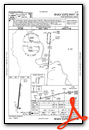
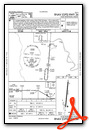
Instrument Approach Procedure (IAP) Charts

Nearby Airports with Instrument Procedures
| ID | Name | Heading / Distance | ||
|---|---|---|---|---|
 |
KBTR | Baton Rouge Metro, Ryan Field Airport | 123° | 20.3 |
|
KOPL | St Landry Parish Airport | 253° | 33.5 |
|
KMKV | Marksville Municipal Airport | 306° | 37.9 |
|
KLFT | Lafayette Regional/Paul Fournet Field Airport | 220° | 40.5 |
|
2R6 | Bunkie Municipal Airport | 290° | 41.6 |
|
KREG | Louisiana Regional Airport | 139° | 43.0 |
|
KARA | Acadiana Regional Airport | 207° | 45.8 |
|
0R4 | Concordia Parish Airport | 358° | 50.5 |
|
4R7 | Eunice Airport | 253° | 51.2 |
|
KIYA | Abbeville Chris Crusta Memorial Airport | 215° | 54.4 |
|
KHEZ | Hardy-Anders Field/Natchez-Adams County Airport | 009° | 54.4 |
|
KHDC | Hammond Northshore Regional Airport | 101° | 56.1 |
Airport Images

By: SV Jenn

By: SV Jenn


