Login
Register


MD70
Flying Acres Airport
Official FAA Data Effective 2026-01-22 0901Z
VFR Chart of MD70
Sectional Charts at SkyVector.com
IFR Chart of MD70
Enroute Charts at SkyVector.com
Location Information for MD70
Coordinates: N39°10.87' / W75°54.53'Located 02 miles W of Sudlersville, Maryland. View all Airports in Maryland.
Estimated Elevation is 70 feet MSL.
Operations Data
|
|
Airport Communications
| AWOS-3 at 33N (14.5 E): | 120.125 302-571-6012 |
|---|---|
| D-ATIS at DOV (20.9 E): | 127.825 |
| AWOS-3 at EVY (22.2 NE): | 132.325 302-378-2063 |
Nearby Navigation Aids
|
| ||||||||||||||||||||||||||||||||||||||||||||||||||||||||||||


Runway 15/33
| Dimensions: | 2200 x 75 feet / 671 x 23 meters | |
|---|---|---|
| Surface: | Turf | |
| Runway 15 | Runway 33 | |
| Traffic Pattern: | Left | |
| Obstacles: | ft Trees ft from runway | ft Power Line ft from runway |
Services Available
| Fuel: | NONE |
|---|---|
| Transient Storage: | NONE |
| Airframe Repair: | NONE |
| Engine Repair: | NONE |
| Bottled Oxygen: | NOT AVAILABLE |
| Bulk Oxygen: | NOT AVAILABLE |
Ownership Information
| Ownership: | Privately Owned | |
|---|---|---|
| Owner: | ROBERT BASTIANELLI | |
| 2521 SUDLERSVILLE RD | ||
| SUDLERSVILLE, MD 21668 | ||
| (410) 438-3360 | ||
| Manager: | ROBERT BASTIANELLI | |
| 2521 SUDLERSVILLE RD | ||
| SUDLERSVILLE, MD 21668 | ||
| (410) 438-3360 | ||
Other Remarks
- FOR CD CTC POTOMAC APCH AT 866-429-5882.
Nearby Airports with Instrument Procedures
| ID | Name | Heading / Distance | ||
|---|---|---|---|---|
 |
KRJD | Gooden Airpark Airport | 171° | 12.8 |
|
33N | Delaware Airpark Airport | 081° | 14.6 |
|
KDOV | Dover AFB Airport | 098° | 20.9 |
|
KEVY | Summit Airport | 022° | 22.1 |
|
W29 | Bay Bridge Airport | 238° | 23.2 |
|
58M | Claremont Airport | 004° | 23.6 |
|
KESN | Easton/Newnam Field Airport | 198° | 23.8 |
|
KMTN | Martin State Airport | 290° | 25.1 |
|
0W3 | Harford County Airport | 329° | 27.0 |
|
KILG | New Castle Airport | 025° | 33.0 |
|
KANP | Lee Airport | 245° | 34.0 |
|
KBWI | Baltimore/Washington International Thurgood Marshall Airport | 269° | 35.5 |
Airport Images
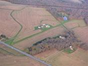
By: jlshoem


