Login
Register


MJX
Ocean County Airport
Official FAA Data Effective 2026-02-19 0901Z
Chart Supplement

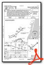
VFR Chart of KMJX
Sectional Charts at SkyVector.com
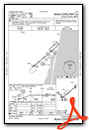
IFR Chart of KMJX
Enroute Charts at SkyVector.com
Location Information for KMJX
Coordinates: N39°55.56' / W74°17.73'Located 05 miles SW of Toms River, New Jersey on 822 acres of land. View all Airports in New Jersey.
Surveyed Elevation is 86 feet MSL.
Operations Data
|
|
Airport Communications
| AWOS-3PT: | 119.875 Tel. 732-797-2542 |
|---|---|
| MC GUIRE APPROACH: | 126.475 363.8 |
| MC GUIRE DEPARTURE: | 126.475 363.8 |
| WAALK STAR: | 124.6 327.125 |
| CTAF: | 122.700 |
| UNICOM: | 122.700 |
| ATIS at NEL (7.1 N): | 276.525 |
| AWOS-AV at N12 (10.0 NE): | 122.8 732-363-6471 |
| D-ATIS at WRI (14.6 W): | 110.6 |
Nearby Navigation Aids
|
| ||||||||||||||||||||||||||||||||||||||||||||||||||||||||||||


Runway 06/24
| Dimensions: | 5950 x 100 feet / 1814 x 30 meters | |
|---|---|---|
| Surface: | Asphalt in Good Condition | |
| Weight Limits: | 45 /F/A/X/T, S-100, D-176, ST-581 | |
| Edge Lighting: | High Intensity | |
| Runway 06 | Runway 24 | |
| Coordinates: | N39°55.33' / W74°18.03' | N39°55.97' / W74°17.06' |
| Elevation: | 75.7 | 75.8 |
| Traffic Pattern: | Left | Left |
| Runway Heading: | 50° True | 230° True |
| Displaced Threshold: | 115 Feet | |
| Declared Distances: | TORA:5950 TODA:5950 ASDA:5835 LDA:5835 | TORA:5950 TODA:5950 ASDA:5950 LDA:5835 |
| Markings: | Precision Instrument in fair condition. | Precision Instrument in fair condition. |
| Glide Slope Indicator | P2L (3.00° Glide Path Angle) | P2L (3.00° Glide Path Angle) |
| Approach Lights: | MALSR 1,400 Foot Medium-intensity Approach Lighting System with runway alignment indicator lights. | |
| REIL: | Yes | |
Runway 14/32
| Dimensions: | 3599 x 75 feet / 1097 x 23 meters | |
|---|---|---|
| Surface: | Asphalt in Good Condition | |
| Weight Limits: | 35 /F/A/X/T, S-94, D-150 | |
| Edge Lighting: | Medium Intensity | |
| Runway 14 | Runway 32 | |
| Coordinates: | N39°55.60' / W74°18.35' | N39°55.23' / W74°17.74' |
| Elevation: | 86.0 | 75.9 |
| Runway Heading: | 128° True | 308° True |
| Markings: | Basic in good condition. | Basic in good condition. |
| Glide Slope Indicator | P2L (3.00° Glide Path Angle) | P2L (3.00° Glide Path Angle) |
| REIL: | Yes | Yes |
Helipad H1
FATO 100X100 FT | ||
| Dimensions: | 100 x 100 feet / 30 x 30 meters | |
|---|---|---|
| Surface: | Asphalt in Good Condition | |
| Coordinates: | N39°55.58' / W74°17.84' | N0°0.00' / E0°0.00' |
| Elevation: | 83.4 | |
Services Available
| Fuel: | 100LL (blue), Jet-A |
|---|---|
| Transient Storage: | Hangars,Tiedowns |
| Airframe Repair: | MAJOR |
| Engine Repair: | MAJOR |
| Bottled Oxygen: | HIGH |
| Bulk Oxygen: | NONE |
| Other Services: | AIR AMBULANCE SERVICES,AVIONICS,PILOT INSTRUCTION,AIRCRAFT RENTAL,AIRCRAFT SALES |
Ownership Information
| Ownership: | Publicly owned | |
|---|---|---|
| Owner: | COUNTY OF OCEAN | |
| 101 HOOPER AVENUE, PO BOX 2191 | ||
| TOMS RIVER, NJ 08754-2191 | ||
| 732-929-2054 | ||
| Manager: | ANTHONY AGLIATA | |
| 129 HOOPER AVENUE, PO BOX 2191 | ||
| TOMS RIVER, NJ 08754-2191 | ||
| (732) 929-2054 | ||
Other Remarks
- DEER & BIRDS ON & INVOF ARPT.
- FOR CD CTC MC GUIRE APCH AT 609-754-2767.
- ACTVT MALSR RWY 06; REIL RWY 14, 32 & 24; PAPI RWY 06, 24, 14 & 32; HIRL RWY 06/24; MIRL RWY 14/32 - CTAF.
Weather Minimums

Standard Terminal Arrival (STAR) Charts


Instrument Approach Procedure (IAP) Charts

Nearby Airports with Instrument Procedures
| ID | Name | Heading / Distance | ||
|---|---|---|---|---|
 |
KNEL | Lakehurst Maxfield Field Airport | 338° | 7.1 |
|
N12 | Lakewood Airport | 032° | 10.0 |
|
KWRI | Mc Guire Field (Joint Base Mc Guire Dix Lakehurst) Airport | 291° | 14.7 |
|
31E | Eagles Nest Airport | 182° | 15.6 |
|
KBLM | Monmouth Exec Airport | 026° | 17.5 |
|
N87 | Trenton-Robbinsville Airport | 320° | 22.3 |
|
N14 | Flying W Airport | 271° | 23.6 |
|
3N6 | Old Bridge Airport | 354° | 24.3 |
|
KVAY | South Jersey Regional Airport | 272° | 25.4 |
|
N81 | Hammonton Municipal Airport | 234° | 26.4 |
|
KACY | Atlantic City International Airport | 205° | 31.0 |
|
19N | Pine Valley Airport | 253° | 31.4 |
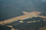
Airport Images

By: N1888E-young
By: N1888E-young


