Login
Register


MLI
Quad Cities International Airport
Official FAA Data Effective 2026-01-22 0901Z
Chart Supplement

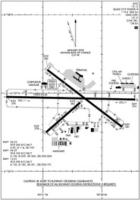
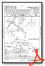
KMLI Airport Diagram
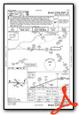
VFR Chart of KMLI
Sectional Charts at SkyVector.com
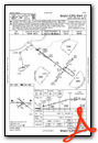
IFR Chart of KMLI
Enroute Charts at SkyVector.com
Location Information for KMLI
Coordinates: N41°26.89' / W90°30.47'Located 03 miles S of Moline, Illinois on 2021 acres of land. View all Airports in Illinois.
Surveyed Elevation is 589 feet MSL.
Operations Data
|
|
Airport Communications
| ATIS: | 121.2 |
|---|---|
| ASOS: | 121.2 Tel. 309-233-0742 |
| QUAD CITY TOWER: | 119.4 269.55 |
| QUAD CITY GROUND: | 121.9 |
| QUAD CITY APPROACH: | 125.95 ;NORTH OF ACTIVE RWY 133.275 ;SOUTH OF ACTIVE RWY 257.8 |
| QUAD CITY DEPARTURE: | 125.95 ;NORTH OF ACTIVE RWY 133.275 ;SOUTH OF ACTIVE RWY 257.8 |
| IC: | 125.95 ;NORTH OF ACTIVE RWY |
| CLEARANCE DELIVERY: | 124.05 |
| EMERG: | 121.5 243.0 |
| CLASS C: | 125.95 ;NORTH OF ACTIVE RWY 133.275 ;SOUTH OF ACTIVE RWY 257.8 |
| UNICOM: | 122.950 |
| CTAF: | 119.400 |
| ASOS at DVN (10.4 N): | 120.175 563-388-2154 |
| AWOS-3PT at CWI (24.3 N): | 125.525 563-243-8934 |
| AWOS-3P at MUT (29.2 W): | 120.625 563-263-0902 |
- APCH/DEP SVC PRVDD BY CHICAGO ARTCC ON FREQS 118.75/377.05 (MOLINE RCAG) WHEN QUAD CITY APCH CLSD.
Nearby Navigation Aids
|
| ||||||||||||||||||||||||||||||||||||||||||||||||||||||||||||


Runway 09/27
| Dimensions: | 10002 x 150 feet / 3049 x 46 meters | |
|---|---|---|
| Surface: | Concrete / Grooved in Good Condition | |
| Weight Limits: | S-120, D-229, ST-369, DT-850
PCR VALUE: 750/R/C/W/T
| |
| Edge Lighting: | High Intensity | |
| Runway 09 | Runway 27 | |
| Coordinates: | N41°26.95' / W90°31.62' | N41°26.92' / W90°29.43' |
| Elevation: | 577.6 | 573.8 |
| Traffic Pattern: | Left | Left |
| Runway Heading: | 91° True | 271° True |
| Declared Distances: | TORA:10002 TODA:10002 ASDA:10002 LDA:10002 | TORA:10002 TODA:10002 ASDA:10002 LDA:10002 |
| Markings: | Precision Instrument in good condition. | Precision Instrument in good condition. |
| Glide Slope Indicator | P4L (3.00° Glide Path Angle) | P4L (3.00° Glide Path Angle) |
| RVR Equipment | Touchdown Rollout | Touchdown Rollout |
| Approach Lights: | MALSR 1,400 Foot Medium-intensity Approach Lighting System with runway alignment indicator lights. | MALSR 1,400 Foot Medium-intensity Approach Lighting System with runway alignment indicator lights. |
| Obstacles: | 207 ft Tree 8959 ft from runway, 1743 ft left of center | |
Runway 13/31
| Dimensions: | 7301 x 150 feet / 2225 x 46 meters | |
|---|---|---|
| Surface: | Asphalt-Concrete / Porous Friction Course in Good Condition | |
| Weight Limits: | S-120, D-185, ST-301, DT-721
PCR VALUE: 590/R/C/W/T
| |
| Edge Lighting: | High Intensity | |
| Runway 13 | Runway 31 | |
| Coordinates: | N41°27.30' / W90°30.93' | N41°26.57' / W90°29.66' |
| Elevation: | 584.7 | 580.9 |
| Traffic Pattern: | Left | Left |
| Runway Heading: | 127° True | 307° True |
| Displaced Threshold: | 522 Feet | |
| Declared Distances: | TORA:7301 TODA:7301 ASDA:7032 LDA:7032 | TORA:7301 TODA:7301 ASDA:6954 LDA:6432 |
| Markings: | Non-Precision Instrument in good condition. | Non-Precision Instrument in good condition. |
| Glide Slope Indicator | P4L (3.00° Glide Path Angle) | P4L (3.00° Glide Path Angle) |
| REIL: | Yes | Yes |
| Obstacles: | 45 ft Tree 1665 ft from runway, 271 ft right of center | 173 ft Tree 5522 ft from runway, 559 ft left of center 140 FT PWR POLE DIST 5836 FT; 415 FT R; 41:1 BASED ON DSPLCD THLD. |
Runway 05/23
| Dimensions: | 3514 x 150 feet / 1071 x 46 meters | |
|---|---|---|
| Surface: | Concrete / Grooved in Good Condition | |
| Weight Limits: | S-92, D-114, ST-193
PCR VALUE: 350/R/C/W/T
| |
| Edge Lighting: | Medium Intensity | |
| Runway 05 | Runway 23 | |
| Coordinates: | N41°26.50' / W90°30.95' | N41°26.88' / W90°30.37' |
| Elevation: | 578.1 | 583.3 |
| Traffic Pattern: | Left | Left |
| Runway Heading: | 49° True | 229° True |
| Declared Distances: | TORA:3514 TODA:3514 ASDA:3514 LDA:3514 | TORA:3514 TODA:3514 ASDA:3514 LDA:3514 |
| Markings: | Basic in fair condition. | Basic in fair condition. |
| Glide Slope Indicator | P4L (4.00° Glide Path Angle) | P4L (3.00° Glide Path Angle) |
Services Available
| Fuel: | 100LL (blue), Jet-A |
|---|---|
| Transient Storage: | Hangars,Tiedowns |
| Airframe Repair: | MAJOR |
| Engine Repair: | MAJOR |
| Bottled Oxygen: | HIGH/LOW |
| Bulk Oxygen: | HIGH/LOW |
| Other Services: | AVIONICS,CARGO HANDLING SERVICES,CHARTER SERVICE,PILOT INSTRUCTION |
Ownership Information
| Ownership: | Publicly owned | |
|---|---|---|
| Owner: | METROPOLITAN AIRPORT AUTH | |
| BOX 9009 | ||
| MOLINE, IL 61265 | ||
| 309-764-9621 | ||
| Manager: | BENJAMIN LEISCHNER | |
| 2200 69TH AVE; SUITE 100 | ||
| MOLINE, IL 61265 | ||
| 309-764-9621 | ||
Other Remarks
- BIRDS & MIGRATORY FOWL ON & INVOF ARPT.
- 0LL 100LL SELF SERVE FUEL PUMP LCTD IN T-HNGR AREA AND OPEN 24 HRS A DAY.
- WHEN ATCT CLSD ACTVT AND INCR INTS RWY & TWY LIGHTING, MALSR RWY 9 & RWY 27; REIL RWY 13 & RWY 31 - CTAF.
Weather Minimums


Instrument Approach Procedure (IAP) Charts
Nearby Airports with Instrument Procedures
| ID | Name | Heading / Distance | ||
|---|---|---|---|---|
 |
KDVN | Davenport Municipal Airport | 339° | 10.4 |
|
KCWI | Clinton Municipal Airport | 019° | 24.3 |
|
KEZI | Kewanee Municipal Airport | 120° | 28.6 |
|
KMUT | Muscatine Municipal Airport | 260° | 29.3 |
|
KGBG | Harrel W Timmons Galesburg Regional Airport | 173° | 30.8 |
|
C66 | Monmouth Municipal Airport | 190° | 31.6 |
|
8C4 | Mathews Memorial Airport | 303° | 34.6 |
|
KOQW | Maquoketa Municipal Airport | 344° | 37.6 |
|
KSFY | Tri-Township Airport | 026° | 40.1 |
|
KSQI | Whiteside County/Jos H Bittorf Field Airport | 064° | 41.4 |
|
KIOW | Iowa City Municipal Airport | 284° | 48.2 |
|
KBRL | Southeast Iowa Regional Airport | 215° | 48.7 |
Airport Images
 from the south")
By: keeganm


