Login
Register


MT21
Lander's Fork Ranch Airport
Official FAA Data Effective 2025-12-25 0901Z
VFR Chart of MT21
Sectional Charts at SkyVector.com
IFR Chart of MT21
Enroute Charts at SkyVector.com
Location Information for MT21
Coordinates: N47°3.22' / W112°32.77'Located 09 miles NE of Lincoln, Montana on 20 acres of land. View all Airports in Montana.
Estimated Elevation is 5089 feet MSL.
Operations Data
|
|
Airport Communications
| ASOS at HLN (35.4 SE): | 120.4 406-290-3397 |
|---|---|
| ATIS at HLN (35.4 SE): | 120.4 |
| AWOS-AV at 38S (40.9 S): | 120.025 406-846-1177 |
Nearby Navigation Aids
|
| ||||||||||||||||||||||||||||||||||||


Runway 16/34
| Dimensions: | 3600 x 80 feet / 1097 x 24 meters | |
|---|---|---|
| Surface: | Turf | |
| Runway 16 | Runway 34 | |
| Obstacles: | 300 ft Hill 1320 ft from runway | |
Ownership Information
| Ownership: | Privately Owned | |
|---|---|---|
| Owner: | VALERIE HEDQUIST | |
| PO BOX 2831 | ||
| MISSOULA, MT 59806 | ||
| 406-829-1614 | ||
| Manager: | VALERIE HEDQUIST | |
| PO BOX 2831 | ||
| MISSOULA, MT 59806 | ||
| 406-829-1614 | ||
Other Remarks
- FOR CD CTC HELENA APCH AT 406-449-5756/5761, WHEN APCH CLSD CTC SALT LAKE ARTCC AT 801-320-2568.
Nearby Airports with Instrument Procedures
| ID | Name | Heading / Distance | ||
|---|---|---|---|---|
 |
KHLN | Helena Regional Airport | 138° | 35.5 |
|
38S | Deer Lodge-City-County Airport | 192° | 41.0 |
|
KCII | Choteau Airport | 018° | 49.0 |
|
KGTF | Great Falls International Airport | 061° | 54.5 |
|
3U3 | Bowman Field Airport | 193° | 55.6 |
|
KMSO | Missoula Montana Airport | 263° | 64.0 |
|
KBTM | Bert Mooney Airport | 178° | 66.0 |
|
32S | Stevensville Airport | 243° | 69.7 |
|
7S0 | Ronan Airport | 296° | 70.6 |
|
S01 | Conrad Airport | 018° | 70.8 |
|
7S6 | White Sulphur Springs Airport | 115° | 75.3 |
|
8S1 | Polson Airport | 300° | 77.2 |
Airport Images
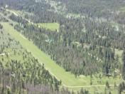
By: stvnnelson


Comments
contact
the phone is 406 362-4350 not the phone on the chart