Login
Register


N03
Cortland County/Chase Field Airport
Official FAA Data Effective 2026-02-19 0901Z
Chart Supplement

VFR Chart of N03
Sectional Charts at SkyVector.com
IFR Chart of N03
Enroute Charts at SkyVector.com
Location Information for N03
Coordinates: N42°35.56' / W76°12.89'Located 02 miles SW of Cortland, New York on 105 acres of land. View all Airports in New York.
Surveyed Elevation is 1197 feet MSL.
Operations Data
|
|
Airport Communications
| AWOS-3: | 132.225 Tel. 607-753-9784 |
|---|---|
| ELMIRA APPROACH: | 118.6 ;S-SE 257.625 124.3 ;W 257.8 ;W 126.125 269.125 |
| SYRACUSE DEPARTURE: | 257.625 126.125 269.125 |
| CTAF: | 122.800 |
| UNICOM: | 122.800 |
| AWOS-3PT at ITH (12.3 SW): | 125.175 607-257-2390 |
| ATIS at ITH (12.4 SW): | 125.175 |
| AWOS-3P at 6B9 (21.8 NW): | 120.125 315-685-5790 |
- APCH SVC PRVDD BY NEW YORK ARTCC ON FREQS 133.35/372.0 (SAYRE RCAG) WHEN ELMIRA APCH CTL AND BINGHAMTON APCH CTL CLSD.
- APPROACHES FROM THE NORTH USE SYRACUSE APCH 126.125/269.125.APPROACHES FROM THE SOUTH-SOUTH EAST USE BINGHAMTON APCH 118.6/257.625.APPROACHES FROM THE WEST USE ELMIRA APCH 124.3/257.8.
Nearby Navigation Aids
|
| ||||||||||||||||||||||||||||||||||||||||||||||||||||||


Runway 06/24
| Dimensions: | 3401 x 75 feet / 1037 x 23 meters | |
|---|---|---|
| Surface: | Asphalt / Grooved in Good Condition | |
| Weight Limits: | S-12 | |
| Edge Lighting: | Medium Intensity | |
| Runway 06 | Runway 24 | |
| Coordinates: | N42°35.37' / W76°13.17' | N42°35.75' / W76°12.62' |
| Elevation: | 1197.3 | 1163.9 |
| Traffic Pattern: | Left | Left |
| Runway Heading: | 46° True | 226° True |
| Markings: | Non-Precision Instrument in good condition. | Non-Precision Instrument in good condition. |
| Glide Slope Indicator | P2L (4.00° Glide Path Angle) | P2L (4.00° Glide Path Angle) |
| REIL: | Yes | |
| Obstacles: | 36 ft Pole 515 ft from runway, 294 ft left of center | 23 ft Trees 665 ft from runway, 178 ft left of center |
Services Available
| Fuel: | 100LL (blue), Jet A+ |
|---|---|
| Transient Storage: | Hangars,Tiedowns |
| Airframe Repair: | MAJOR |
| Engine Repair: | MAJOR |
| Bottled Oxygen: | NONE |
| Bulk Oxygen: | NONE |
| Other Services: | PILOT INSTRUCTION,AIRCRAFT RENTAL |
Ownership Information
| Ownership: | Publicly owned | |
|---|---|---|
| Owner: | CORTLAND COUNTY | |
| 60 CENTRAL AVE. | ||
| CORTLAND, NY 13045 | ||
| 607-753-9377 | ||
| Manager: | MATT WETHERELL | |
| 60 CENTRAL AVE. | ||
| CORTLAND, NY 13045 | ||
| 607-745-5872 | ||
Other Remarks
- SNOW REMOVAL DRG DAY ONLY.
- HVY CONCENTRATION OF GEESE AND GULLS ON AND INVOF ARPT DRG SPRING/FALL.
- FOR CD CTC SYRACUSE APCH AT 315-455-6218.
- 0LL SELF SVC AVBL 24 HRS WITH CREDIT CARD.
- SELF SVC AVBL 24 HRS WITH CREDIT CARD.
- ACTVT REIL RWY 24; PAPI RWY 06 & 24; MIRL RWY 06/24; TWY LGTS - CTAF.
Weather Minimums


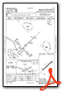
Instrument Approach Procedure (IAP) Charts


Nearby Airports with Instrument Procedures
| ID | Name | Heading / Distance | ||
|---|---|---|---|---|
 |
KITH | Ithaca Tompkins International Airport | 240° | 12.4 |
|
6B9 | Skaneateles Aero Drome Airport | 332° | 21.7 |
|
KBGM | Greater Binghamton/Edwin A Link Field Airport | 155° | 25.3 |
|
0G7 | Finger Lakes Regional Airport | 305° | 30.5 |
|
KOIC | Lt Warren Eaton Airport | 092° | 30.7 |
|
KCZG | Tri-Cities Airport | 170° | 31.3 |
|
KSYR | Syracuse Hancock International Airport | 008° | 31.5 |
|
KVGC | Hamilton Municipal Airport | 062° | 32.6 |
|
B16 | Whitfords Airport | 334° | 32.6 |
|
KPEO | Penn Yan/Yates County Airport | 274° | 37.2 |
|
N23 | Sidney Municipal Airport | 115° | 39.5 |
|
KELM | Elmira/Corning Regional Airport | 229° | 39.7 |
Airport Images
Do you have a recent image of this airport? Upload it here!


Comments
Friendly Folks
Great little airport, friendly flight school and cheap gas.