Login
Register


NJ24
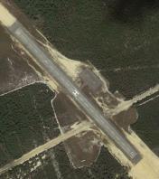
Warren Grove Range Airport
Official FAA Data Effective 2026-01-22 0901Z
VFR Chart of NJ24
Sectional Charts at SkyVector.com
IFR Chart of NJ24
Enroute Charts at SkyVector.com
Location Information for NJ24
Coordinates: N39°41.86' / W74°24.01'Located 03 miles SW of Burlington County, New Jersey. View all Airports in New Jersey.
Estimated Elevation is 135 feet MSL.
Operations Data
|
|
Airport Communications
| AWOS-3PT at MJX (14.7 N): | 119.875 732-797-2542 |
|---|---|
| ASOS at ACY (16.6 SW): | 609-277-2644 |
| ATIS at ACY (16.6 SW): | 125.725 |
Nearby Navigation Aids
|
| ||||||||||||||||||||||||||||||||||||||||||||||||||||||


Runway 15/33
| Dimensions: | 1800 x 75 feet / 549 x 23 meters | |
|---|---|---|
| Surface: | Asphalt in Fair Condition | |
| Edge Lighting: | Non-Standard GREEN RY LGTS. | |
| Runway 15 | Runway 33 | |
| Coordinates: | N39°41.97' / W74°24.14' | N39°41.75' / W74°23.88' |
| Elevation: | 122.0 | 135.0 |
Ownership Information
| Ownership: | Owned by the Army | |
|---|---|---|
| Owner: | NJ AIR NATIONAL GUARD | |
| DET 1, 400 LANGLEY RD | ||
| EGG HARBOR, NJ 08234 | ||
| 609-761-6700 | ||
| Manager: | NJ AIR NATIONAL GUARD | |
| DET 1, 400 LANGLEY RD | ||
| EGG HARBOR, NJ 08234 | ||
| 609-761-6700 | ||
Other Remarks
- FOR CD CTC WASHINGTON ARTCC AT 703-771-3587.
- RY 15/33 LGTS ACTVT - 121.95.
Nearby Airports with Instrument Procedures
| ID | Name | Heading / Distance | ||
|---|---|---|---|---|
 |
31E | Eagles Nest Airport | 114° | 4.7 |
|
KMJX | Ocean County Airport | 019° | 14.5 |
|
KACY | Atlantic City International Airport | 209° | 16.6 |
|
N81 | Hammonton Municipal Airport | 263° | 16.7 |
|
KNEL | Lakehurst Maxfield Field Airport | 006° | 20.4 |
|
KWRI | Mc Guire Field (Joint Base Mc Guire Dix Lakehurst) Airport | 335° | 21.0 |
|
N14 | Flying W Airport | 307° | 23.6 |
|
N12 | Lakewood Airport | 024° | 24.4 |
|
KVAY | South Jersey Regional Airport | 305° | 25.3 |
|
19N | Pine Valley Airport | 280° | 25.8 |
|
26N | Ocean City Municipal Airport | 200° | 27.8 |
|
17N | Cross Keys Airport | 271° | 29.3 |
Airport Images
By: usmcuav


Comments
Runway Location
The runway is not at the listed coordinates. It is centered on 39.697711,-74.400193
Mark