Login
Register
EDU
University Airport
Official FAA Data Effective 2026-01-22 0901Z
VFR Chart of KEDU
Sectional Charts at SkyVector.com
IFR Chart of KEDU
Enroute Charts at SkyVector.com
Location Information for KEDU
Coordinates: N38°31.89' / W121°47.19'Located 02 miles W of Davis, California on 95 acres of land. View all Airports in California.
Surveyed Elevation is 69 feet MSL.
Operations Data
|
|
Airport Communications
| AWOS-3: | 119.025 Tel. 530-754-6839 |
|---|---|
| TRAVIS APPROACH: | 126.6 281.45 |
| TRAVIS DEPARTURE: | 126.6 281.45 |
| UNICOM: | 123.075 |
| CTAF: | 123.075 |
| AWOS-3P at DWA (4.3 NW): | 125.775 530-750-2759 |
| ASOS at VCB (12.3 SW): | 134.75 707-240-8032 |
| D-ATIS at SMF (13.5 NE): | 126.75 |
Nearby Navigation Aids
|
| ||||||||||||||||||||||||||||||||||||
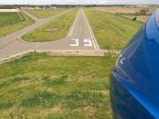
Runway 17/35
| Dimensions: | 3176 x 60 feet / 968 x 18 meters | |
|---|---|---|
| Surface: | Asphalt in Excellent Condition | |
| Edge Lighting: | Medium Intensity | |
| Runway 17 | Runway 35 | |
| Coordinates: | N38°32.15' / W121°47.18' | N38°31.63' / W121°47.19' |
| Elevation: | 62.0 | 68.8 |
| Traffic Pattern: | Left | Left |
| Runway Heading: | 181° True | 1° True |
| Markings: | Non-Precision Instrument in good condition. | Basic in good condition. |
| Glide Slope Indicator | P2L (3.25° Glide Path Angle) | P2L (3.25° Glide Path Angle) |
| REIL: | Yes | Yes |
| Obstacles: | 40 ft Tree 1113 ft from runway, 246 ft left of center | 61 ft Trees 1431 ft from runway, 221 ft left of center |
Services Available
| Fuel: | 100LL (blue) |
|---|---|
| Transient Storage: | Tiedowns |
| Airframe Repair: | MAJOR |
| Engine Repair: | MAJOR |
| Bottled Oxygen: | NONE |
| Bulk Oxygen: | NONE |
| Other Services: | PILOT INSTRUCTION,AIRCRAFT RENTAL |
Ownership Information
| Ownership: | Publicly owned | |
|---|---|---|
| Owner: | UNIVERSITY OF CALIFORNIA | |
| OFFICE OF ADMIN & RESOURCE MGT, TB206 | ||
| DAVIS, CA 95616 | ||
| 530-752-0100 | ||
| Manager: | PERRY H EGGLESTON | |
| TRANSP & PARKING SERVICES, 1 SHIELDS AVE | ||
| DAVIS, CA 95616-8724 | ||
| 530-752-5435 | ||
Other Remarks
- 65 FT TREES LCTD S SIDE OF CREEK 1257 FT FM THR RWY 35.
- TREES +40 FT, W SIDE OF RWY NEAR RWY 17 THR.
- NOISE ABATEMENT, NOISE SENSITIVE AREA N OF ARPT.
- AFTER HRS EMERG: UC DAVIS POLICE 530-752-1230. AFTER HRS NON-EMERG: UC DAVIS POLICE 530-752-1727.
- CAUTION: REMOTE CTL ACFT WI AREA DEFINED AS 0.5 NM RAD OF 3835N/12142W (5 NM NE EDU), SFC - 1200 FT AGL, SR-SS.
- FOR CD CTC OAKLAND ARTCC AT 510-745-3380.
- 0LL FUEL SELF-SERVICE AVBL 24 HRS.
- ACTVT REIL RWY 17 & 35; PAPI RWY 17 & 35; MIRL RWY 17/35 - CTAF.
Weather Minimums
Instrument Approach Procedure (IAP) Charts
Nearby Airports with Instrument Procedures
| ID | Name | Heading / Distance | ||
|---|---|---|---|---|
 |
KDWA | Yolo County Airport | 310° | 4.4 |
 |
O41 | Watts-Woodland Airport | 334° | 9.4 |
 |
KVCB | Nut Tree Airport | 221° | 12.3 |
 |
KSMF | Sacramento International Airport | 043° | 13.5 |
 |
KSAC | Sacramento Exec Airport | 094° | 13.8 |
 |
KSUU | Travis AFB Airport | 202° | 17.3 |
 |
KMCC | Mc Clellan Airfield Airport | 065° | 19.9 |
 |
O88 | Rio Vista Municipal Airport | 169° | 20.6 |
 |
KMHR | Sacramento Mather Airport | 086° | 23.1 |
 |
KAPC | Napa County Airport | 230° | 30.1 |
 |
KLHM | Lincoln Regional/Karl Harder Field Airport | 041° | 30.5 |
 |
1O3 | Lodi Airport | 128° | 31.4 |


Comments
AWOS
http://awos.ucdavis.edu/
University Airport is
University Airport is committed to providing and developing quality services, facilities and programs to meet aviation demands of our clients while achieving positive financial results.http://350-001-real-exam.blogspot.com/
turkey airport transfer
turkey airport transfer company www.havaalanitransfer.com all of them airport and shuttle than airport tansfer
atatürk airport
sabiga gökçen airport
dalaman airport
ankara esenboga airport
izmir airport
mugla airport
antalya airport transfer
turkey airport transfer
turkey airport transfer company www.havaalanitransfer.com all of them airport and shuttle than airport tansfer
atatürk airport
sabiga gökçen airport
dalaman airport
ankara esenboga airport
izmir airport
mugla airport
antalya airport transfer
Pages