Login
Register


ACV
California Redwood Coast-Humboldt County Airport
Official FAA Data Effective 2025-11-27 0901Z
Chart Supplement

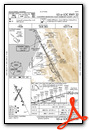
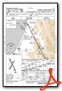
KACV Airport Diagram

VFR Chart of KACV
Sectional Charts at SkyVector.com
IFR Chart of KACV
Enroute Charts at SkyVector.com
Location Information for KACV
Coordinates: N40°58.67' / W124°6.51'Located 07 miles N of Arcata/Eureka, California on 745 acres of land. View all Airports in California.
Surveyed Elevation is 222 feet MSL.
Operations Data
|
|
Airport Communications
| ASOS: | 118.525 Tel. 707-839-7429 |
|---|---|
| CTAF: | 123.000 |
| UNICOM: | 123.000 |
| AWOS-3 at FOT (25.5 S): | 133.8 707-725-2909 |
| ASOS at CEC (48.7 N): | 119.925 707-465-5458 |
| AWOS-2 at O16 (55.3 S): | 133.0 707-923-4291 |
- APCH/DEP CTL SVC PRVDD BY SEATTLE ARTCC (ZSE) ON FREQS 124.85/306.3 (ARCATA RCAG).
Nearby Navigation Aids
|
| ||||||||||||||||||||||||||||||||||||||||||


Runway 14/32
| Dimensions: | 6046 x 150 feet / 1843 x 46 meters | |
|---|---|---|
| Surface: | Asphalt / Grooved in Good Condition | |
| Weight Limits: | S-60, D-155, ST-280
PCR VALUE: 530/F/D/X/T
| |
| Edge Lighting: | High Intensity | |
| Runway 14 | Runway 32 | |
| Coordinates: | N40°59.12' / W124°6.79' | N40°58.23' / W124°6.19' |
| Elevation: | 182.9 | 222.3 |
| Traffic Pattern: | Right | Left |
| Runway Heading: | 153° True | 333° True |
| Displaced Threshold: | 245 Feet | 200 Feet |
| Declared Distances: | TORA:6046 TODA:6046 ASDA:5846 LDA:5601 | TORA:6046 TODA:6046 ASDA:6046 LDA:5846 |
| Markings: | Precision Instrument in good condition. | Precision Instrument in good condition. |
| Glide Slope Indicator | P4L (3.00° Glide Path Angle) | P4L (3.00° Glide Path Angle) |
| RVR Equipment | Touchdown Rollout | Touchdown Rollout |
| Approach Lights: | MALSR 1,400 Foot Medium-intensity Approach Lighting System with runway alignment indicator lights. | |
| REIL: | Yes | |
| Centerline Lights: | Yes | Yes |
| Obstacles: | 91 ft Tree 2625 ft from runway, 875 ft right of center | |
Runway 01/19
RWY 01/19 NOT AVBL FOR PART 121/PART 380 OPS WITH SKED PAX CARRYING OPS MORE THAN 9 PAX SEATS AND NON-SKED PAX CARRYING OPS MORE THAN 30 PAX SEATS. | ||
| Dimensions: | 4501 x 150 feet / 1372 x 46 meters | |
|---|---|---|
| Surface: | Asphalt / Grooved in Fair Condition | |
| Weight Limits: | S-60, D-95, ST-170
PCR VALUE: 62/F/D/X/U
| |
| Edge Lighting: | Medium Intensity | |
| Runway 01 | Runway 19 | |
| Coordinates: | N40°58.34' / W124°6.78' | N40°58.99' / W124°6.29' |
| Elevation: | 187.4 | 208.3 |
| Traffic Pattern: | Left | Right |
| Runway Heading: | 30° True | 210° True |
| Declared Distances: | TORA:4501 TODA:4501 ASDA:4501 LDA:4501 | TORA:4501 TODA:4501 ASDA:4501 LDA:4501 |
| Markings: | Non-Precision Instrument in fair condition. | Non-Precision Instrument in fair condition. |
| Glide Slope Indicator | V4L (3.00° Glide Path Angle) | |
| REIL: | Yes | |
| Obstacles: | 142 ft Trees 3450 ft from runway | |
Services Available
| Fuel: | 100LL (blue), Jet-A |
|---|---|
| Transient Storage: | Tiedowns |
| Airframe Repair: | NONE |
| Engine Repair: | NONE |
| Bottled Oxygen: | NONE |
| Bulk Oxygen: | NONE |
| Other Services: | CARGO HANDLING SERVICES |
Ownership Information
| Ownership: | Publicly owned | |
|---|---|---|
| Owner: | HUMBOLDT COUNTY | |
| 1106 SECOND ST | ||
| EUREKA, CA 95501 | ||
| (707) 496-0102 | ||
| Manager: | RYAN COOLEY | EMAIL: RCOOLEY@CO.HUMBOLDT.CA.US |
| 3561 BOEING AVE. | ||
| MCKINLEYVILLE, CA 95519 | ||
| 707-839-5401 | ||
Other Remarks
- FOR CD IF UNA TO CTC ON FSS FREQ, CTC SEATTLE ARTCC AT 253-351-3694.
- 0LL FUEL AVBL 0400-2400 LOCAL, AND AFTER HOURS WITH ADVANCED NOTICE.
- ACTVT MALSR RWY 32; TDZL RWY 32; C/L LGTS RWY 14 & 32; REIL RWY 14; PAPI RWY 14 & 32; HIRL RWY 14/32 - CTAF. MIRL RWY 01/19, REIL RWY 01, AND VASI RWY 01 PPR CTC 707-382-2551 OR 707-496-0102.
- ENGINEERED MATERIAL ARRESTING SYSTEM (EMAS) 280 FT IN LEN BY 170 FT IN WID STARTING 70 FT BYD DER 32.
Weather Minimums

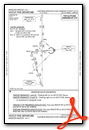
Instrument Approach Procedure (IAP) Charts
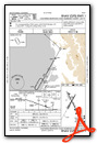
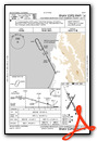
Departure Procedure (DP) Charts
Nearby Airports with Instrument Procedures
| ID | Name | Heading / Distance | ||
|---|---|---|---|---|
 |
KEKA | Murray Field Airport | 181° | 10.5 |
|
KFOT | Rohnerville Airport | 182° | 25.4 |
|
KCEC | Jack Mc Namara Field Airport | 353° | 48.5 |
|
KBOK | Brookings Airport | 352° | 66.2 |
|
O46 | Weed Airport | 067° | 80.7 |
|
O85 | Benton Field Airport | 106° | 81.2 |
|
KRDD | Redding Regional Airport | 108° | 87.4 |
|
4S1 | Gold Beach Municipal Airport | 350° | 87.4 |
|
3S8 | Grants Pass Airport | 019° | 97.4 |
|
O28 | Ells Field/Willits Municipal Airport | 159° | 97.6 |
|
KRBL | Red Bluff Municipal Airport | 119° | 98.3 |
|
KMFR | Rogue Valley International/Medford Airport | 033° | 100.5 |
Airport Images
Do you have a recent image of this airport? Upload it here!


