Login
Register


HUS
Hughes Airport
Official FAA Data Effective 2026-01-22 0901Z
Chart Supplement

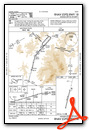
VFR Chart of PAHU
Sectional Charts at SkyVector.com
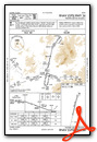
IFR Chart of PAHU
Enroute Charts at SkyVector.com
Location Information for PAHU
Coordinates: N66°2.34' / W154°15.88'Located 01 miles SW of Hughes, Alaska. View all Airports in Alaska.
Surveyed Elevation is 298 feet MSL.
Operations Data
|
|
Airport Communications
| CTAF: | 122.900 |
|---|---|
| AWOS-3 at UTO (14.0 E): | 907-552-3211 |
- APCH/DEP SVC PRVDD BY ANCHORAGE ARTCC (ZAN) ON 124.6/352.0 (BETTLES RCAG).
Nearby Navigation Aids
|
| ||||||||||||||||||||||||


Runway 18/36
| Dimensions: | 3381 x 100 feet / 1031 x 30 meters | |
|---|---|---|
| Surface: | Gravel in Good Condition | |
| Edge Lighting: | Medium Intensity | |
| Runway 18 | Runway 36 | |
| Coordinates: | N66°2.61' / W154°15.72' | N66°2.08' / W154°16.05' |
| Elevation: | 298.6 | 296.7 |
| Traffic Pattern: | Left | Left |
| Runway Heading: | 194° True | 14° True |
| Markings: | Non-Standard in fair condition. | Non-Standard in fair condition. |
| Obstacles: | 15 ft Trees 0 ft from runway, 108 ft right of center | 15 ft Trees 0 ft from runway, 105 ft right of center |
Services Available
| Fuel: | NONE |
|---|---|
| Transient Storage: | NONE |
| Airframe Repair: | NONE |
| Engine Repair: | NONE |
| Bottled Oxygen: | NONE |
| Bulk Oxygen: | NONE |
Ownership Information
| Ownership: | Publicly owned | |
|---|---|---|
| Owner: | ALASKA DOT&PF NORTHERN REGION | |
| 2301 PEGER RD | ||
| FAIRBANKS, AK 99709 | ||
| (907) 451-5280 | ||
| Manager: | JASON LUDINGTON | |
| 2301 PEGER RD | ||
| FAIRBANKS, AK 99709 | ||
| (907) 451-5280 | ||
Other Remarks
- RWY CONDITION NOT MONITORED; RECOMMEND VISUAL INSPECTION PRIOR TO LANDING.
- SNOW REMOVAL OPERATIONS DURING WINTER - MONITOR CTAF.
- SOUTH SAFETY AREA SOFT & RUTTED.
- TWY A UNLIT.
- TWY A REFLECTORS 36 INCHES TALL.
- 150 FT X 100 FT TURN AROUND NORTH SIDE OF RWY.
- ACTVT MIRL RWY 18/36 - CTAF.
- ACTVT ROTATING BEACON - CTAF.
Weather Minimums

Instrument Approach Procedure (IAP) Charts
Departure Procedure Obstacles (DPO) Charts

Nearby Airports with Instrument Procedures
| ID | Name | Heading / Distance | ||
|---|---|---|---|---|
 |
PFAL | Allakaket Airport | 051° | 50.4 |
|
PAHL | Huslia Airport | 249° | 55.4 |
|
PATA | Ralph M Calhoun Memorial Airport | 133° | 74.8 |
|
PAOB | Kobuk Airport | 310° | 82.3 |
|
PABT | Bettles Airport | 050° | 84.3 |
|
PARY | Ruby Airport | 201° | 84.6 |
|
PAGH | Shungnak Airport | 307° | 86.5 |
|
PAGA | Edward G Pitka Sr Airport | 221° | 103.2 |
Airport Images
Do you have a recent image of this airport? Upload it here!


