Login
Register


P20
Avi Suquilla Airport
Official FAA Data Effective 2026-02-19 0901Z
Chart Supplement

VFR Chart of P20
Sectional Charts at SkyVector.com
IFR Chart of P20
Enroute Charts at SkyVector.com
Location Information for P20
Coordinates: N34°8.99' / W114°16.07'Located 01 miles E of Parker, Arizona on 590 acres of land. View all Airports in Arizona.
Estimated Elevation is 458 feet MSL.
Operations Data
|
|
Airport Communications
| AWOS-3PT: | 132.75 Tel. 928-669-2160 |
|---|---|
| CTAF: | 122.725 |
| UNICOM: | 122.725 |
| AWOS-3 at HII (25.3 N): | 119.025 928-764-2309 |
| ASOS at BLH (38.9 SW): | 120.175 760-922-3000 |
| ASOS at EED (41.0 NW): | 128.325 760-326-4281 |
- APCH/DEP CTL SVC PRVDD BY LOS ANGELES ARTCC (ZLA) ON FREQS 128.15/285.6 (LAGUNA RCAG).
Nearby Navigation Aids
|
| ||||||||||||||||||||||||||||||||||||

Runway 02/20
INT TKOF FM TWY A-2 NA. 150 FT BLAST PADS BOTH ENDS. | ||
| Dimensions: | 6250 x 100 feet / 1905 x 30 meters | |
|---|---|---|
| Surface: | Asphalt in Good Condition | |
| Weight Limits: | S-30, D-50 | |
| Edge Lighting: | Medium Intensity | |
| Runway 02 | Runway 20 | |
| Coordinates: | N34°8.53' / W114°16.34' | N34°9.45' / W114°15.80' |
| Elevation: | 453.6 | 456.8 |
| Traffic Pattern: | Right | Left |
| Runway Heading: | 26° True | 206° True |
| Markings: | Non-Precision Instrument in fair condition. | Non-Precision Instrument in fair condition. |
| Glide Slope Indicator | P4L (3.00° Glide Path Angle) | P4L (3.00° Glide Path Angle) |
Services Available
| Fuel: | 100LL (blue), Jet A+ |
|---|---|
| Transient Storage: | Hangars,Tiedowns |
| Airframe Repair: | MINOR AIRFRAME/POWER PLANT SVC - AMGR |
| Engine Repair: | MINOR |
| Bottled Oxygen: | NOT AVAILABLE |
| Bulk Oxygen: | NOT AVAILABLE |
Ownership Information
| Ownership: | Publicly owned | |
|---|---|---|
| Owner: | COLORADO RIVER INDIAN TRIBES | |
| 26600 MOHAVE ROAD | ||
| PARKER, AZ 85344 | ||
| 928-669-2168 | ||
| Manager: | JOSH PHILLIPS | |
| 28940 AIRPORT ROAD | ||
| PARKER, AZ 85344 | ||
| 928-669-2168 | ||
Other Remarks
- INTMT HIGH ALT MIL PAJA ACT INVOF OF AIRPT.
- FOR CD CTC LOS ANGELES ARTCC AT 661-575-2079.
- ACTVT MIRL RWY 02/20; TWY LGTS - CTAF.
Weather Minimums

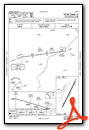
Instrument Approach Procedure (IAP) Charts

Nearby Airports with Instrument Procedures
| ID | Name | Heading / Distance | ||
|---|---|---|---|---|
 |
KHII | Lake Havasu City Airport | 349° | 25.6 |
|
KBLH | Blythe Airport | 215° | 38.9 |
|
KEED | Needles Airport | 334° | 40.9 |
|
KIFP | Laughlin/Bullhead International Airport | 346° | 61.9 |
|
KIGM | Kingman Airport | 013° | 68.4 |
|
KTNP | Twentynine Palms Airport | 269° | 83.6 |
|
KCLR | Cliff Hatfield Memorial Airport | 226° | 87.5 |
|
KNYL | Yuma MCAS/Yuma International Airport | 190° | 91.0 |
|
KBWC | Brawley Municipal Airport | 222° | 93.4 |
|
KPRC | Prescott Regional/Ernest A Love Field Airport | 071° | 96.6 |
|
KTRM | Jacqueline Cochran Regional Airport | 252° | 99.6 |
|
KLUF | Luke AFB Airport | 110° | 101.1 |
Airport Images
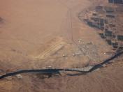
By: Dave


