Login
Register


EED
Needles Airport
Official FAA Data Effective 2026-01-22 0901Z
Chart Supplement

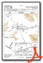
VFR Chart of KEED
Sectional Charts at SkyVector.com
IFR Chart of KEED
Enroute Charts at SkyVector.com
Location Information for KEED
Coordinates: N34°45.98' / W114°37.40'Located 05 miles S of Needles, California on 796 acres of land. View all Airports in California.
Surveyed Elevation is 983 feet MSL.
Operations Data
|
|
Airport Communications
| ASOS: | 128.325 Tel. 760-326-4281 |
|---|---|
| UNICOM: | 123.000 |
| CTAF: | 123.000 |
| AWOS-3 at HII (18.0 SE): | 119.025 928-764-2309 |
| AWOS-3PT at IFP (23.2 N): | 119.825 928-754-4462 |
| ATIS at IFP (23.5 N): | 119.825 |
- APCH/DEP CTL SVC PRVDD BY LOS ANGELES ARTCC (ZLA) ON FREQUENCIES 134.65/360.65 (NELSON RCAG).
Nearby Navigation Aids
|
| ||||||||||||||||||||||||||||||||||||


Runway 11/29
| Dimensions: | 5005 x 100 feet / 1526 x 30 meters | |
|---|---|---|
| Surface: | Asphalt in Poor Condition CRACKS IN PAVEMENT | |
| Weight Limits: | S-16, D-32 | |
| Edge Lighting: | Medium Intensity | |
| Runway 11 | Runway 29 | |
| Coordinates: | N34°46.02' / W114°38.02' | N34°45.62' / W114°37.15' |
| Elevation: | 983.1 | 918.5 |
| Traffic Pattern: | Left | Left |
| Runway Heading: | 119° True | 299° True |
| Markings: | Basic in fair condition. | Basic in fair condition. |
| Glide Slope Indicator | P2L (3.00° Glide Path Angle) | P2L (3.00° Glide Path Angle) |
| REIL: | Yes | Yes |
Runway 02/20
| Dimensions: | 4235 x 100 feet / 1291 x 30 meters | |
|---|---|---|
| Surface: | Asphalt in Poor Condition CRACKS IN PAVEMENT. | |
| Weight Limits: | S-16, D-32 | |
| Edge Lighting: | Medium Intensity | |
| Runway 02 | Runway 20 | |
| Coordinates: | N34°45.86' / W114°37.38' | N34°46.47' / W114°36.97' |
| Elevation: | 929.4 | 843.9 |
| Traffic Pattern: | Left | Left |
| Runway Heading: | 29° True | 209° True |
| Markings: | Non-Precision Instrument in fair condition. | Non-Precision Instrument in fair condition. |
| Glide Slope Indicator | P2L (3.00° Glide Path Angle) | P2L (3.00° Glide Path Angle) |
Services Available
| Fuel: | 100LL (blue), Jet-A |
|---|---|
| Transient Storage: | Tiedowns |
| Airframe Repair: | MINOR |
| Engine Repair: | MINOR |
| Bottled Oxygen: | NONE |
| Bulk Oxygen: | NONE |
Ownership Information
| Ownership: | Publicly owned | |
|---|---|---|
| Owner: | CO OF SAN BERNARDINO | |
| 777 E RIALTO | ||
| SAN BERNARDINO, CA 92415 | ||
| 909-387-7810 | ||
| Manager: | MAUREEN A. SNELGROVE | |
| 711 AIRPORT RD | ||
| NEEDLES, CA 92363 | ||
| 909-387-8810 | ||
Other Remarks
- <UNLGTD MTN WEST & SOUTH OF ARPT APRX 3200' MSL.
- (E81) 2 LGTS EACH SIDE MARKING RWY EXITS; REFLECTORS MARKING TWYS.
- FOR CD IF UNA TO CTC ON FSS FREQ, CTC LOS ANGELES ARTCC AT 661-575-2079.
- NSTD MARKINGS FOR INSTR APCH; BSC INSTEAD OF NPI MARKINGS.
- 0LL 100LL FUEL AVBL 24 HRS SELF SRV
- JET A FUEL AVBL 24 HRS SELF SVC
- ACTVT MIRL RY 11/29 & RY 02/20, REIL RY 11& RY 29 - CTAF. PAPI RY 11, RY 29, RY 02 & RY 20 OPER CONTINUOUSLY.
Weather Minimums

Instrument Approach Procedure (IAP) Charts

Nearby Airports with Instrument Procedures
| ID | Name | Heading / Distance | ||
|---|---|---|---|---|
 |
KHII | Lake Havasu City Airport | 131° | 17.6 |
|
KIFP | Laughlin/Bullhead International Airport | 007° | 23.5 |
|
P20 | Avi Suquilla Airport | 154° | 40.9 |
|
KIGM | Kingman Airport | 048° | 44.9 |
|
KBLH | Blythe Airport | 183° | 68.9 |
|
KBVU | Boulder City Municipal Airport | 350° | 71.7 |
|
KTNP | Twentynine Palms Airport | 240° | 75.8 |
|
KHND | Henderson Exec Airport | 341° | 76.5 |
|
KLAS | Harry Reid International Airport | 341° | 82.9 |
|
KLSV | Nellis AFB Airport | 347° | 90.3 |
|
KVGT | North Las Vegas Airport | 342° | 90.9 |
|
KUDD | Bermuda Dunes Airport | 233° | 102.3 |
Airport Images
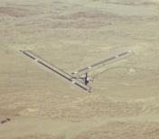
By: Dave


