Login
Register


ENN
Nenana Municipal Airport
Official FAA Data Effective 2025-11-27 0901Z
Chart Supplement

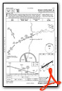
VFR Chart of PANN
Sectional Charts at SkyVector.com
IFR Chart of PANN
Enroute Charts at SkyVector.com
Location Information for PANN
Coordinates: N64°32.84' / W149°4.44'Located 01 miles S of Nenana, Alaska on 1030 acres of land. View all Airports in Alaska.
Surveyed Elevation is 367 feet MSL.
Operations Data
|
|
Airport Communications
| ASOS: | 125.2 Tel. 907-832-5689 |
|---|---|
| FAIRBANKS APPROACH: | 125.35 363.2 363.2 ;180-359 |
| FAIRBANKS DEPARTURE: | 125.35 363.2 363.2 |
| IC: | 363.2 ;180-359 |
| CTAF: | 122.100 |
| ASOS at FAI (35.2 NE): | 124.4 907-621-7609 |
| ATIS at FAI (35.2 NE): | 124.4 |
| ATIS at FBK (41.3 NE): | 134.25 |
- COMMUNICATIONS PRVDD BY FAIRBANKS FSS ON FREQ 122.50 (NENANA RCO).
Nearby Navigation Aids
|
| ||||||||||||||||||||||||||||||||||||||||||


Runway 04L/22R
| Dimensions: | 4600 x 100 feet / 1402 x 30 meters | |
|---|---|---|
| Surface: | Asphalt in Good Condition | |
| Weight Limits: | S-160 | |
| Edge Lighting: | Medium Intensity OTS INDEF. | |
| Runway 04L | Runway 22R | |
| Coordinates: | N64°32.74' / W149°5.22' | N64°33.13' / W149°3.72' |
| Elevation: | 367.6 | 365.2 |
| Traffic Pattern: | Right | Left |
| Runway Heading: | 59° True | 239° True |
| Markings: | Non-Precision Instrument in good condition. | Non-Precision Instrument in good condition. |
| Glide Slope Indicator | P4L (3.00° Glide Path Angle) | P4L (3.00° Glide Path Angle) |
| REIL: | Yes | Yes |
| Obstacles: | 30 ft Trees 201 ft from runway, 220 ft left of center | 31 ft Trees 360 ft from runway, 142 ft right of center |
Runway 04W/22W
| Dimensions: | 3601 x 100 feet / 1098 x 30 meters | |
|---|---|---|
| Surface: | Water | |
| Runway 04W | Runway 22W | |
| Coordinates: | N64°32.56' / W149°4.84' | N64°32.89' / W149°3.71' |
| Elevation: | 352.1 | 352.1 |
| Traffic Pattern: | Right | |
| Runway Heading: | 56° True | 236° True |
| Markings: | Buoys in good condition. | Buoys in good condition. |
Runway 04R/22L
| Dimensions: | 1980 x 80 feet / 604 x 24 meters FULL LEN MAY BE UNAVBL DURG SUMMER. SKI USE WHEN FROZEN. | |
|---|---|---|
| Surface: | Turf in Good Condition | |
| Edge Lighting: | Medium Intensity OTS INDEF. | |
| Runway 04R | Runway 22L | |
| Coordinates: | N64°32.75' / W149°4.97' | N64°32.91' / W149°4.32' |
| Elevation: | 363.8 | 363.5 |
| Traffic Pattern: | Right | |
| Runway Heading: | 59° True | 239° True |
| Markings: | None in fair condition. | None in fair condition. |
| Obstacles: | 30 ft Trees 0 ft from runway, 65 ft right of center | 23 ft Trees 0 ft from runway, 70 ft left of center |
Services Available
| Fuel: | 100LL (blue), Jet-A |
|---|---|
| Transient Storage: | Tiedowns |
| Airframe Repair: | NOT AVAILABLE |
| Engine Repair: | NOT AVAILABLE |
| Bottled Oxygen: | NOT AVAILABLE |
| Bulk Oxygen: | NOT AVAILABLE |
Ownership Information
| Ownership: | Publicly owned | |
|---|---|---|
| Owner: | CITY OF NENANA | |
| BOX 70 | ||
| NENANA, AK 99760 | ||
| 907-832-5441 | ||
| Manager: | DAN SMITH | |
| NENANA, AK 99760 | ||
| 907-888-9065 | ||
Other Remarks
- SHALLOW WATER NEAR FLOAT POND RAMP AREA.
- WX CAMERA AVBL ON INTERNET AT HTTPS://WEATHERCAMS.FAA.GOV
- RWY COND UNMNT; RCMD VISUAL INSP BFR USE.
- SELF SVC FUEL H24 WITH CREDIT CARD.
- ACTVT REIL RWY 04L & 22R; PAPI 04L & 22R; MIRL RWY 04L/22R - CTAF.
Weather Minimums
Instrument Approach Procedure (IAP) Charts

Nearby Airports with Instrument Procedures
| ID | Name | Heading / Distance | ||
|---|---|---|---|---|
 |
PAFA | Fairbanks International Airport | 062° | 35.3 |
|
PAHV | Healy River Airport | 176° | 41.0 |
|
PAML | Manley Hot Springs Airport | 303° | 48.4 |
|
PAEI | Eielson AFB Airport | 081° | 51.5 |
|
PAWB | Beaver Airport | 020° | 117.0 |
, view from SW")
, view from W")


