Login
Register


VDZ
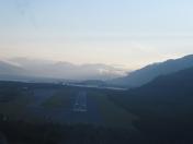
Valdez Pioneer Field Airport
Official FAA Data Effective 2026-01-22 0901Z
Chart Supplement

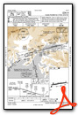
VFR Chart of PAVD
Sectional Charts at SkyVector.com
IFR Chart of PAVD
Enroute Charts at SkyVector.com
Location Information for PAVD
Coordinates: N61°8.05' / W146°14.69'Located 03 miles E of Valdez, Alaska on 836 acres of land. View all Airports in Alaska.
Surveyed Elevation is 128 feet MSL.
Operations Data
|
|
Airport Communications
| AWOS-3P: | 118.8 Tel. 907-560-7614 |
|---|---|
| CTAF: | 122.900 |
| ASOS at CDV (45.4 SE): | 134.8 907-424-5900 |
| AWOS-3P at AZK (55.0 NW): | 134.95 907-822-3011 |
- APCH/DEP SVC PRVDD BY ANCHORAGE ARTCC ON FREQS 269.4 (MIDDLETON ISLAND RCAG) AND 119.3 (JOHNSTONE POINT RCAG).
- COMMUNICATIONS PRVDD BY JUNEAU FSS ON FREQ 122.2 (VALDEZ RCO).
Nearby Navigation Aids
|
| ||||||||||||||||||||||||||||||||||||


Runway 06/24
| Dimensions: | 6500 x 150 feet / 1981 x 46 meters | |
|---|---|---|
| Surface: | Asphalt / Grooved in Good Condition | |
| Weight Limits: | S-107, D-187, ST-346
PCR VALUE: 407/F/A/X/T
| |
| Edge Lighting: | High Intensity | |
| Runway 06 | Runway 24 | |
| Coordinates: | N61°7.97' / W146°15.78' | N61°8.13' / W146°13.60' |
| Elevation: | 57.4 | 128.0 |
| Traffic Pattern: | Right | Left |
| Runway Heading: | 81° True | 261° True |
| Declared Distances: | TORA:6500 TODA:6500 ASDA:6500 LDA:6500 | TORA:6500 TODA:6500 ASDA:6500 LDA:6500 |
| Markings: | Precision Instrument in fair condition. | Non-Precision Instrument in fair condition. |
| Glide Slope Indicator | P4L (3.00° Glide Path Angle) | |
| Approach Lights: | MALSR 1,400 Foot Medium-intensity Approach Lighting System with runway alignment indicator lights. | |
| REIL: | Yes | |
| Obstacles: | 55 ft Trees 2100 ft from runway | 77 ft Trees 1580 ft from runway |
Services Available
| Fuel: | 100LL (blue), Jet-A |
|---|---|
| Transient Storage: | NONE |
| Airframe Repair: | MINOR |
| Engine Repair: | MINOR |
| Bottled Oxygen: | NOT AVAILABLE |
| Bulk Oxygen: | NOT AVAILABLE |
| Other Services: | CARGO HANDLING SERVICES |
Ownership Information
| Ownership: | Publicly owned | |
|---|---|---|
| Owner: | ALASKA DOT&PF NORTHERN REGION | |
| 2301 PEGER ROAD | ||
| FAIRBANKS, AK 99709 | ||
| 907-451-2200 | ||
| Manager: | DAVE WILEY | |
| BOX 507 | ||
| VALDEZ, AK 99686 | ||
| 907-835-5658 | ||
Other Remarks
- 1675 X 200 FT SW PTN OF RAMP NOT MNTND NOV 1 - APR 15.
- MAINT HRS MON-FRI 0600-1830; SAT & SUN 0800-1830.
- ALERT: DURG STRONG N WIND; MIDFIELD & E END RWY WIND MAY BE MUCH HYR THAN AWOS INDCD.
- ALERT: SEE SPL NOTICE - PORT VALDEZ AREA & GENOTS - THOMPSON PASS AVALANCHE CTL.
- POTATO POINT WX CAMERA AVBL ON INTERNET AT HTTPS://WEATHERCAMS.FAA.GOV
- ARPT SAND LRGR THAN FAA RCMDD/SEE AC150/5200-30.
- COLD TEMPERATURE AIRPORT. ALTITUDE CORRECTION REQUIRED AT OR BELOW -10C.
- PPR - 907-834-6933.
- ACTVT MALSR RWY 06; REIL RWY 24; PAPI RWY 06; HIRL RWY 06/24 - CTAF.
Weather Minimums


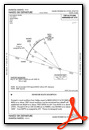
Instrument Approach Procedure (IAP) Charts
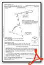
Departure Procedure (DP) Charts
Departure Procedure Obstacles (DPO) Charts
Nearby Airports with Instrument Procedures
| ID | Name | Heading / Distance | ||
|---|---|---|---|---|
 |
PAKA | Tatitlek Airport | 219° | 20.5 |
|
PACV | Merle K (Mudhole) Smith Airport | 149° | 44.8 |
|
PAGK | Gulkana Airport | 019° | 65.4 |
|
PAAQ | Warren "Bud" Woods Palmer Municipal Airport | 289° | 86.7 |
|
PAMD | Middleton Island Airport | 181° | 101.3 |