Login
Register


PAQ
Warren "Bud" Woods Palmer Municipal Airport
Official FAA Data Effective 2025-11-27 0901Z
Chart Supplement

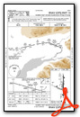
VFR Chart of PAAQ
Sectional Charts at SkyVector.com
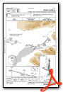
IFR Chart of PAAQ
Enroute Charts at SkyVector.com
Location Information for PAAQ
Coordinates: N61°35.70' / W149°5.32'Located 01 miles SE of Palmer, Alaska. View all Airports in Alaska.
Surveyed Elevation is 248 feet MSL.
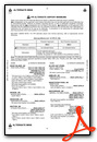
Operations Data
|
|
Airport Communications
| ASOS: | 134.75 Tel. 907-746-6675 |
|---|---|
| ANCHORAGE APPROACH: | 118.6 290.5 |
| ANCHORAGE DEPARTURE: | 118.6 290.5 |
| CTAF: | 123.600 |
| AWOS-3P at IYS (13.0 W): | 135.25 907-373-3801 |
| AWOS-3P at BCV (16.2 SW): | 135.55 907-621-7605 |
| ATIS at FRN (25.6 SW): | 134.25 |
- FOR A LOCAL CALL TO PALMER FSS DIAL 745-2495. AFIS AVBL ON 134.75.
- COMMUNICATIONS PRVDD BY PALMER FSS ON FREQS 122.4 & 123.6 (CTAF).
Nearby Navigation Aids
|
| ||||||||||||||||||||||||||||||||||||


Runway 16/34
| Dimensions: | 6006 x 100 feet / 1831 x 30 meters | |
|---|---|---|
| Surface: | Asphalt in Good Condition | |
| Weight Limits: | 34 /F/B/X/U, S-180 | |
| Edge Lighting: | Medium Intensity | |
| Runway 16 | Runway 34 | |
| Coordinates: | N61°36.24' / W149°5.25' | N61°35.25' / W149°5.24' |
| Elevation: | 248.6 | 220.8 |
| Traffic Pattern: | Left | Left |
| Runway Heading: | 180° True | 360° True |
| Displaced Threshold: | 503 Feet | |
| Declared Distances: | TORA:6008 TODA:6008 ASDA:6008 LDA:5508 | TORA:6008 TODA:6008 ASDA:6008 LDA:6008 |
| Markings: | Basic in fair condition. | Basic in fair condition. |
| Glide Slope Indicator | P4L (3.00° Glide Path Angle) | P4L (3.00° Glide Path Angle) PAPI RWY 34 UNUSBL BYD 5.4 NM; DOES NOT PRVD OBSTN CLNC BYD 5.4 NM FM THR. |
| REIL: | Yes | Yes |
| Obstacles: | 79 ft Trees 1123 ft from runway, 337 ft right of center | 67 ft Trees 1300 ft from runway, 295 ft right of center |
Runway 10/28
CLSD TO ACFT OVER 12500 LB. | ||
| Dimensions: | 3616 x 75 feet / 1102 x 23 meters | |
|---|---|---|
| Surface: | Asphalt in Good Condition | |
| Weight Limits: | 7 /F/B/X/U | |
| Edge Lighting: | Medium Intensity | |
| Runway 10 | Runway 28 | |
| Coordinates: | N61°35.70' / W149°6.04' | N61°35.46' / W149°4.89' |
| Elevation: | 233.4 | 227.6 |
| Traffic Pattern: | Left | Left |
| Runway Heading: | 113° True | 293° True |
| Markings: | Basic in fair condition. | Basic in fair condition. |
| Glide Slope Indicator | P2L (3.00° Glide Path Angle) | P2L (3.00° Glide Path Angle) PAPI RWY 28 UNUSBL BYD 3.0 NM; DOES NOT PRVD OBSTN CLNC BYD 3.0 NM FM THR. |
| Obstacles: | 15 ft Road 200 ft from runway, 200 ft right of center CTL OBS EXCEEDS 45 DEG SLP. ROAD 200 FT R 5-200 FT FM THR. |
5 ft Hill 240 ft from runway, 235 ft right of center |
Runway 16S/34S
AVBL W SIDE & PARL TO RWY 16/34; SIMUL PARL OPS NA; THR & EDGE MKD WITH CONES; WINTER MAINT NA; SEQ - CTAF. | ||
| Dimensions: | 1560 x 60 feet / 475 x 18 meters | |
|---|---|---|
| Surface: | Gravel in Good Condition | |
| Runway 16S | Runway 34S | |
| Coordinates: | N61°35.89' / W149°5.28' | N61°35.63' / W149°5.28' |
| Elevation: | 238.5 | 231.0 |
| Runway Heading: | 180° True | 360° True |
Helipad H1
| Dimensions: | 50 x 50 feet / 15 x 15 meters | |
|---|---|---|
| Surface: | Asphalt in Fair Condition | |
| Coordinates: | N61°35.21' / W149°5.46' | N0°0.00' / E0°0.00' |
| Elevation: | 222.0 | |
Services Available
| Fuel: | 100LL (blue), Jet A-1 |
|---|---|
| Transient Storage: | NONE |
| Airframe Repair: | MAJOR |
| Engine Repair: | MAJOR |
| Bottled Oxygen: | NOT AVAILABLE |
| Bulk Oxygen: | NOT AVAILABLE |
| Other Services: | AIR FREIGHT SERVICES,CARGO HANDLING SERVICES,CHARTER SERVICE,PILOT INSTRUCTION,AIRCRAFT RENTAL,AIRCRAFT SALES |
Ownership Information
| Ownership: | Publicly owned | |
|---|---|---|
| Owner: | CITY OF PALMER | |
| 231 W EVERGREEN | ||
| PALMER, AK 99645-6952 | ||
| 907-745-3271 | ||
| Manager: | JOHN DIUMENTI | |
| 231 W EVERGREEN | ||
| PALMER, AK 99645 | ||
| 907-761-1334 | ||
Other Remarks
- FIRE TANKER BASE N END; MULT LRG ACFT FLTS ACT MAY-SEP; USE DSGND RUNUP AREA & GIVE WAY TO EMERG ACFT; INFO - FSS 907-745-2495 OR 122.4.
- AFIS AVBL PAQ FSS WHEN OPN; OTR TIMES KENAI FSS - 134.75.
- WATERFOWL & BIRDS ON ARPT; SPCLY SPRING & FALL.
- SKY DIVING & GLIDER ACT ON & INVOF ARPT APR-SEP; BANNER TOWING OPS MAY-OCT THU-SUN.
- WX CAMERA AVBL ON INTERNET AT HTTPS://WEATHERCAMS.FAA.GOV
- TSNT PRKG N RAMP SPACES T1-T9 ADJ FSS: LRG ACFT TSNT PRKG S RAMP SPACES T10, T11 & T12.
- RWY COND AVBL 1000 M-F; WKEND & HOL NA.
- 7 FT FENCE 435 FT W OF THR.
- FUEL AVBL N & S RAMP H24 WITH CREDIT CARD.
- WHEN FSS CLSD ACTVT REIL RWY 16 & 34; PAPI RWY 10, 28, 16 & 34; MIRL RWY 16/34 & 10/28 - CTAF.
Weather Minimums
Instrument Approach Procedure (IAP) Charts
Departure Procedure Obstacles (DPO) Charts

Nearby Airports with Instrument Procedures
| ID | Name | Heading / Distance | ||
|---|---|---|---|---|
 |
PAWS | Wasilla Airport | 264° | 13.0 |
|
PAGQ | Big Lake Airport | 260° | 21.1 |
|
PAUO | Willow Airport | 289° | 29.2 |
|
PAED | Elmendorf AFB Airport | 225° | 29.2 |
|
PAMR | Merrill Field Airport | 223° | 31.7 |
|
PANC | Ted Stevens Anchorage International Airport | 226° | 36.5 |
|
PATK | Talkeetna Airport | 327° | 52.2 |
|
PAKA | Tatitlek Airport | 120° | 82.0 |
|
PAVD | Valdez Pioneer Field Airport | 107° | 86.7 |
|
PAEN | Kenai Municipal Airport | 226° | 87.9 |
|
PASX | Soldotna Airport | 221° | 88.2 |
|
PAWD | Seward Airport | 186° | 88.7 |
Airport Images
Do you have a recent image of this airport? Upload it here!


