Login
Register


PHT
Henry County Airport
Official FAA Data Effective 2026-01-22 0901Z
Chart Supplement

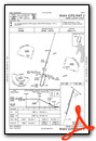
VFR Chart of KPHT
Sectional Charts at SkyVector.com
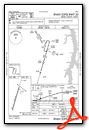
IFR Chart of KPHT
Enroute Charts at SkyVector.com
Location Information for KPHT
Coordinates: N36°20.16' / W88°23.07'Located 03 miles NW of Paris, Tennessee on 250 acres of land. View all Airports in Tennessee.
Surveyed Elevation is 580 feet MSL.
Operations Data
|
|
Airport Communications
| AWOS-3: | 118.825 Tel. 731-644-0451 |
|---|---|
| CTAF: | 123.000 |
| UNICOM: | 123.000 |
| AWOS-3 at HZD (15.3 S): | 133.275 731-352-2854 |
| AWOS-3 at CEY (19.7 N): | 119.975 270-489-2424 |
| AWOS-3 at M25 (27.8 N): | 120.625 270-247-2094 |
- APCH/DEP SVC PRVDD BY MEMPHIS ARTCC ON FREQS 134.65/316.15 (MCKELLAR RCAG).
Nearby Navigation Aids
|
| ||||||||||||||||||||||||||||||||||||||||||||||||||||||||||||


Runway 02/20
| Dimensions: | 5001 x 100 feet / 1524 x 30 meters | |
|---|---|---|
| Surface: | Asphalt in Good Condition | |
| Weight Limits: | 10 /F/D/X/T, S-27 | |
| Edge Lighting: | Medium Intensity L.E.D | |
| Runway 02 | Runway 20 | |
| Coordinates: | N36°19.76' / W88°23.21' | N36°20.55' / W88°22.92' |
| Elevation: | 580.2 | 568.0 |
| Traffic Pattern: | Left | Left |
| Runway Heading: | 16° True | 196° True |
| Markings: | Precision Instrument in good condition. | Precision Instrument in good condition. |
| Glide Slope Indicator | P4L (3.00° Glide Path Angle) PAPI UNUSBL BYD 8 DEG RIGHT & 8 DEG LEFT OF CNTRLN. | P4L (3.00° Glide Path Angle) PAPI UNUSBL BYD 9 DEG RIGHT OF CNTRLN. |
| REIL: | Yes | Yes |
Services Available
| Fuel: | 100LL (blue), Jet A+ |
|---|---|
| Transient Storage: | Hangars,Tiedowns |
| Airframe Repair: | NONE |
| Engine Repair: | NONE |
| Bottled Oxygen: | NONE |
| Bulk Oxygen: | NONE |
| Other Services: | CROP DUSTING SERVICES,PILOT INSTRUCTION |
Ownership Information
| Ownership: | Publicly owned | |
|---|---|---|
| Owner: | HENRY COUNTY | |
| P.O. BOX 7 | ||
| PARIS, TN 38242 | ||
| 731-642-5212 | ||
| Manager: | BOBBY NOLAN | |
| 1949 DIGGS RD | ||
| PARIS, TN 38242 | ||
| 731-644-7933 | AFT HR 731-336-6860/731-333-7317. | |
Other Remarks
- ULTRALIGHTS ARE NOT TO CROSS RWY 02/20.
- PARALLEL TWY UNLGTD.
- FOR CD CTC MEMPHIS ARTCC AT 901-368-8453/8449.
- REIL RWY 02/20; MIRL RWY 02/20 OPR DUSK-DAWN. PAPI RWY 02/20 OPR CONSLY.
Weather Minimums


Instrument Approach Procedure (IAP) Charts
Nearby Airports with Instrument Procedures
| ID | Name | Heading / Distance | ||
|---|---|---|---|---|
 |
KHZD | Sgt Lee Russell Carroll County Airport | 194° | 15.3 |
|
KCEY | Kyle-Oakley Field Airport | 001° | 19.7 |
|
0M4 | Benton County Airport | 147° | 23.3 |
|
M25 | Mayfield Graves County Airport | 339° | 27.7 |
|
1M7 | Fulton Airport | 293° | 28.2 |
|
KUCY | Everett-Stewart Regional Airport | 275° | 29.3 |
|
KTGC | Gibson County Airport | 223° | 33.1 |
|
0M5 | Humphreys County Airport | 112° | 34.0 |
|
M53 | Humboldt Municipal Airport | 216° | 39.9 |
|
M34 | Kentucky Dam State Park Airport | 005° | 40.6 |
|
KPVE | Beech River Regional Airport | 167° | 41.7 |
|
KPAH | Barkley Regional Airport | 336° | 47.3 |
Airport Images

By: axisofentropy@g...


