Login
Register


0M5
Humphreys County Airport
Official FAA Data Effective 2026-02-19 0901Z
Chart Supplement

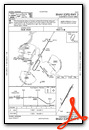
VFR Chart of 0M5
Sectional Charts at SkyVector.com
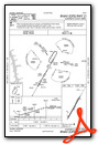
IFR Chart of 0M5
Enroute Charts at SkyVector.com
Location Information for 0M5
Coordinates: N36°7.00' / W87°44.29'Located 03 miles NE of Waverly, Tennessee on 160 acres of land. View all Airports in Tennessee.
Surveyed Elevation is 755 feet MSL.
Operations Data
|
|
Airport Communications
| UNICOM: | 122.800 |
|---|---|
| CTAF: | 122.800 |
| AWOS-3 at M02 (15.1 E): | 123.875 615-446-5481 |
| ATIS at EOD (29.8 NE): | 306.5 |
| AWOS-3 at EOD (29.8 NE): | 270-956-3100 |
- APCH/DEP SVC PRVDD BY MEMPHIS ARTCC ON FREQS 125.85/379.25 (CENTERVILLE RCAG).
Nearby Navigation Aids
|
| ||||||||||||||||||||||||||||||||||||||||||||||||||||||||||||


Runway 03/21
| Dimensions: | 4000 x 75 feet / 1219 x 23 meters | |
|---|---|---|
| Surface: | Asphalt in Good Condition | |
| Weight Limits: | S-30 | |
| Edge Lighting: | Medium Intensity | |
| Runway 03 | Runway 21 | |
| Coordinates: | N36°6.71' / W87°44.49' | N36°7.28' / W87°44.08' |
| Elevation: | 754.7 | 739.5 |
| Traffic Pattern: | Left | Left |
| Runway Heading: | 30° True | 210° True |
| Markings: | Non-Precision Instrument in good condition. | Non-Precision Instrument in good condition. |
| Glide Slope Indicator | P2L (3.00° Glide Path Angle) | P2L (3.00° Glide Path Angle) |
| REIL: | Yes | Yes |
| Obstacles: | 114 ft Tree 3672 ft from runway, 237 ft left of center | 34 ft Tree 557 ft from runway, 149 ft right of center |
Services Available
| Fuel: | 100LL (blue), Jet A+ |
|---|---|
| Transient Storage: | Hangars,Tiedowns |
| Airframe Repair: | NOT AVAILABLE |
| Engine Repair: | NOT AVAILABLE |
| Bottled Oxygen: | NOT AVAILABLE |
| Bulk Oxygen: | NOT AVAILABLE |
| Other Services: | PARACHUTE JUMP ACTIVITY |
Ownership Information
| Ownership: | Publicly owned | |
|---|---|---|
| Owner: | HUMPHREYS COUNTY | |
| COUNTY COURTHOUSE, RM 1, ANNEX BLDG | ||
| WAVERLY, TN 37185 | ||
| 931-296-7795 | ||
| Manager: | JEFF FINCHER | |
| 1005 AIRPORT ROAD | ||
| WAVERLY, TN 37185 | ||
| 931-296-2719 | 205-496-8130 | |
Other Remarks
- THIS AIRPORT HAS BEEN SURVEYED BY THE NATIONAL GEODETIC SURVEY.
- FOR CD CTC MEMPHIS ARTCC AT 901-368-8453/8449.
- LCL SKYDIVING OPS FRI-SUN.
- WILDLIFE ON & INVOF ARPT.
- 0LL FUEL AVBL 24/7 WITH CC.
- ACTVT REIL RWY 03/21 - CTAF.
Weather Minimums

Instrument Approach Procedure (IAP) Charts
Nearby Airports with Instrument Procedures
| ID | Name | Heading / Distance | ||
|---|---|---|---|---|
 |
M02 | Dickson Municipal Airport | 087° | 15.0 |
|
0M4 | Benton County Airport | 251° | 19.9 |
|
KGHM | Centerville Municipal Airport | 139° | 22.0 |
|
KPHT | Henry County Airport | 292° | 34.0 |
|
KCKV | Outlaw Field Airport | 027° | 34.1 |
|
0M3 | Paul Bridges Field Airport | 168° | 34.9 |
|
KHZD | Sgt Lee Russell Carroll County Airport | 267° | 35.3 |
|
KHOP | Campbell AAF (Fort Campbell) Airport | 019° | 35.4 |
|
KPVE | Beech River Regional Airport | 219° | 35.5 |
|
KJWN | John C Tune Airport | 084° | 41.6 |
|
KMRC | Maury County Regional Airport | 140° | 43.3 |
|
KCEY | Kyle-Oakley Field Airport | 317° | 45.0 |
Airport Images
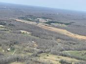
By: Big Orange Bird


